Maps Uncovered: Distinguishing Political and Physical Features
Interactive Video
•
Geography, Social Studies
•
3rd - 5th Grade
•
Practice Problem
•
Hard

Patricia Brown
FREE Resource
Read more
10 questions
Show all answers
1.
MULTIPLE CHOICE QUESTION
30 sec • 1 pt
What materials are required for today's lesson on maps?
A calculator and a notebook
A workbook, pencil, and crayon or marker
A globe and a ruler
A laptop and a textbook
2.
MULTIPLE CHOICE QUESTION
30 sec • 1 pt
What do political maps primarily show?
Boundaries of countries, states, and towns
Weather patterns and climate zones
Population density and demographics
Geographical features like mountains and rivers
3.
MULTIPLE CHOICE QUESTION
30 sec • 1 pt
Which of the following is NOT typically found on a political map?
Names of cities and towns
Names of mountains and rivers
Boundaries between regions
Names of countries and states
4.
MULTIPLE CHOICE QUESTION
30 sec • 1 pt
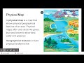
What additional details do physical maps provide compared to political maps?
Historical landmarks
Names of countries and states
Geographical features like deserts and lakes
Population statistics
5.
MULTIPLE CHOICE QUESTION
30 sec • 1 pt
Which feature is commonly found on both political and physical maps?
Boundaries of countries and states
Names of geographical features
Population density
Weather patterns
6.
MULTIPLE CHOICE QUESTION
30 sec • 1 pt
How do physical maps help us understand a region?
By indicating population density
By highlighting historical events
By displaying geographical features
By showing political boundaries
7.
MULTIPLE CHOICE QUESTION
30 sec • 1 pt
What is a key similarity between political and physical maps?
Both show geographical features
Both display weather patterns
Both indicate where places are located
Both highlight historical events
Access all questions and much more by creating a free account
Create resources
Host any resource
Get auto-graded reports
Continue with Google

Continue with Email
Continue with Classlink
Continue with Clever
or continue with
Microsoft
%20(1).png)
Apple
Others
Already have an account?
