Geography of Latin America and the Caribbean
Interactive Video
•
Geography, Social Studies, World Languages
•
6th - 7th Grade
•
Practice Problem
•
Hard

Patricia Brown
FREE Resource
Read more
10 questions
Show all answers
1.
MULTIPLE CHOICE QUESTION
30 sec • 1 pt
What is the main task for students in this lesson?
Create a political and physical map of Mexico, Central America, and the Caribbean.
Prepare a presentation on Asian geography.
Write an essay on Latin American history.
Create a political and physical map of Europe.
2.
MULTIPLE CHOICE QUESTION
30 sec • 1 pt
Which ocean borders Latin America to the west?
Arctic Ocean
Pacific Ocean
Indian Ocean
Atlantic Ocean
3.
MULTIPLE CHOICE QUESTION
30 sec • 1 pt
What are the larger islands of the Caribbean formed from?
Underwater mountains
Sand dunes
Volcanic eruptions
Coral reefs
4.
MULTIPLE CHOICE QUESTION
30 sec • 1 pt
Which river flows through the world's largest tropical rainforest?
Nile River
Mississippi River
Yangtze River
Amazon River
5.
MULTIPLE CHOICE QUESTION
30 sec • 1 pt
What natural phenomenon affects the climate of Latin America by causing floods and droughts?
Hurricane
La Niña
Monsoon
El Niño
6.
MULTIPLE CHOICE QUESTION
30 sec • 1 pt
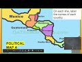
Which countries should be labeled on the political map of Central America?
Only Mexico
All countries in South America
Mexico and Central American countries
Only Caribbean countries
7.
MULTIPLE CHOICE QUESTION
30 sec • 1 pt
What should be drawn on the political map to indicate direction?
A compass rose
A legend
A scale bar
A grid
Access all questions and much more by creating a free account
Create resources
Host any resource
Get auto-graded reports
Continue with Google

Continue with Email
Continue with Microsoft
or continue with

%20(1).png)
Apple
Others
Already have an account?
