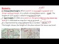
Map Height Representation and Types
Interactive Video
•
Geography, Science, Mathematics
•
9th - 10th Grade
•
Practice Problem
•
Hard

Patricia Brown
FREE Resource
Read more
10 questions
Show all answers
1.
MULTIPLE CHOICE QUESTION
30 sec • 1 pt
What symbol is used to represent a triangulated height on a map?
A square with a number
A triangle with a number
A star with a number
A circle with a number
2.
MULTIPLE CHOICE QUESTION
30 sec • 1 pt
Which height is measured from the mean sea level?
Relative height
Benchmark height
Spot height
Triangulated height
3.
MULTIPLE CHOICE QUESTION
30 sec • 1 pt
How is a spot height represented on a map?
A square with a number
A dot followed by a number
A line with a number
A triangle with a number
4.
MULTIPLE CHOICE QUESTION
30 sec • 1 pt
What does the 'BM' symbol on a map indicate?
Benchmark height
Base map
Building marker
Boundary marker
5.
MULTIPLE CHOICE QUESTION
30 sec • 1 pt
Benchmark heights are determined by which group of professionals?
Architects
Surveyors
Geologists
Engineers
6.
MULTIPLE CHOICE QUESTION
30 sec • 1 pt
What does a relative height represent?
The height above mean sea level
The difference between maximum and minimum heights
The height of a building
The depth of a well
7.
MULTIPLE CHOICE QUESTION
30 sec • 1 pt
How is relative height indicated on a map?
A triangle with a number
A dot followed by a number
A line with a number
A small 'r' followed by a number
Access all questions and much more by creating a free account
Create resources
Host any resource
Get auto-graded reports
Continue with Google

Continue with Email
Continue with Classlink
Continue with Clever
or continue with
Microsoft
%20(1).png)
Apple
Others
Already have an account?
