Africa: Geography and Demographics
Interactive Video
•
Geography, History, Social Studies
•
9th - 12th Grade
•
Practice Problem
•
Hard

Patricia Brown
FREE Resource
Read more
10 questions
Show all answers
1.
MULTIPLE CHOICE QUESTION
30 sec • 1 pt
What is the common belief about Africa's size in many educational systems?
Africa is the third largest continent.
Africa is the largest continent.
Africa is the second largest continent.
Africa is the smallest continent.
2.
MULTIPLE CHOICE QUESTION
30 sec • 1 pt
What percentage of the Earth's total surface area does Africa cover?
15%
6%
20%
10%
3.
MULTIPLE CHOICE QUESTION
30 sec • 1 pt
Which continent has the youngest population according to the 2012 median age statistics?
South America
Asia
Europe
Africa
4.
MULTIPLE CHOICE QUESTION
30 sec • 1 pt
What is the significance of Africa's young population in the global context?
It results in a lack of resources.
It makes Africa a major tourist destination.
It contributes to Africa's economic market importance.
It leads to higher unemployment rates.
5.
MULTIPLE CHOICE QUESTION
30 sec • 1 pt
Who was the first to draw a map of Africa in 1554?
Ortelius Abraham
Ptolemy
Sebastian Munster
Androvo Gaujon
6.
MULTIPLE CHOICE QUESTION
30 sec • 1 pt
What was a significant flaw in the earliest maps of Africa?
They showed Africa as a one-eyed giant.
They depicted Africa as a small island.
They included no countries.
They were drawn by Africans.
7.
MULTIPLE CHOICE QUESTION
30 sec • 1 pt
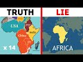
Which map projection is known for depicting Africa as much smaller than its actual size?
Peters Projection
Mercator Projection
Equal Earth Projection
Robinson Projection
Access all questions and much more by creating a free account
Create resources
Host any resource
Get auto-graded reports
Continue with Google

Continue with Email
Continue with Classlink
Continue with Clever
or continue with
Microsoft
%20(1).png)
Apple
Others
Already have an account?
