Understanding Large and Small Scale Maps
Interactive Video
•
Geography
•
6th - 7th Grade
•
Practice Problem
•
Easy

Patricia Brown
Used 1+ times
FREE Resource
Read more
10 questions
Show all answers
1.
MULTIPLE CHOICE QUESTION
30 sec • 1 pt
What is the main difference between large scale and small scale maps?
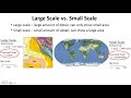
Large scale maps cover a large area with less detail.
Small scale maps cover a small area with more detail.
Large scale maps cover a small area with more detail.
Small scale maps cover a large area with more detail.
2.
MULTIPLE CHOICE QUESTION
30 sec • 1 pt
Which of the following is a characteristic of large scale maps?
They provide detailed views of small areas.
They show the entire world.
They are less detailed than small scale maps.
They have a larger denominator in their fractional scale.
3.
MULTIPLE CHOICE QUESTION
30 sec • 1 pt
What is a typical feature of small scale maps?
They show detailed city streets.
They cover large areas with less detail.
They are used for local planning.
They have a smaller numerator in their fractional scale.
4.
MULTIPLE CHOICE QUESTION
30 sec • 1 pt
How can you determine which map is larger scale using fractional scales?
By looking at the larger denominator.
By comparing the numerators.
By identifying the map with the smaller denominator.
By checking which map covers more area.
5.
MULTIPLE CHOICE QUESTION
30 sec • 1 pt
What does a fractional scale of 1/16,000 indicate?
The map is a large scale map with more detail.
The map is a small scale map.
The map covers a large area with less detail.
The map is less detailed than a map with a scale of 1/190,000,000.
6.
MULTIPLE CHOICE QUESTION
30 sec • 1 pt
Which map would have more detail: one with a scale of 1/16,000 or 1/190,000,000?
Both have the same level of detail.
1/190,000,000
1/16,000
It depends on the map's purpose.
7.
MULTIPLE CHOICE QUESTION
30 sec • 1 pt
What should you consider to identify the largest scale map?
The map's title.
The color of the map.
The level of detail and the representative fraction.
The amount of area covered.
Access all questions and much more by creating a free account
Create resources
Host any resource
Get auto-graded reports
Continue with Google

Continue with Email
Continue with Classlink
Continue with Clever
or continue with
Microsoft
%20(1).png)
Apple
Others
Already have an account?
