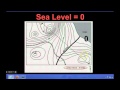
Understanding Contour Maps and Intervals
Interactive Video
•
Geography, Science, Mathematics
•
6th - 7th Grade
•
Practice Problem
•
Hard

Patricia Brown
FREE Resource
Read more
10 questions
Show all answers
1.
MULTIPLE CHOICE QUESTION
30 sec • 1 pt
What is the primary purpose of a contour map?
To show political boundaries
To display weather patterns
To indicate elevation levels
To map out road networks
2.
MULTIPLE CHOICE QUESTION
30 sec • 1 pt
What do contour lines on a map represent?
Points of equal temperature
Points of equal distance
Points of equal elevation
Points of equal population
3.
MULTIPLE CHOICE QUESTION
30 sec • 1 pt
How is a contour interval defined?
The distance between two points
The difference in elevation between two adjacent contour lines
The time taken to travel between two points
The angle of a slope
4.
MULTIPLE CHOICE QUESTION
30 sec • 1 pt
If a contour map has lines marked 100, 200, and 300, what is the contour interval?
200
50
100
150
5.
MULTIPLE CHOICE QUESTION
30 sec • 1 pt
What does it mean when contour lines are close together on a map?
The area is underwater
The area has a steep slope
The area is densely populated
The area is flat
6.
MULTIPLE CHOICE QUESTION
30 sec • 1 pt
In a contour map, what does the center circle typically represent?
The highest point
A forest area
A water body
The lowest point
7.
MULTIPLE CHOICE QUESTION
30 sec • 1 pt
What is the contour interval of a map if the lines are marked 0, 1000, 2000, and 3000 feet?
1500 feet
1000 feet
2000 feet
500 feet
Access all questions and much more by creating a free account
Create resources
Host any resource
Get auto-graded reports
Continue with Google

Continue with Email
Continue with Classlink
Continue with Clever
or continue with
Microsoft
%20(1).png)
Apple
Others
Already have an account?
