Geography of the Middle East
Interactive Video
•
Geography
•
6th - 7th Grade
•
Practice Problem
•
Hard

Patricia Brown
FREE Resource
Read more
10 questions
Show all answers
1.
MULTIPLE CHOICE QUESTION
30 sec • 1 pt
Which regions are collectively studied as the Middle East, North Africa, and Southwest Asia?
North America and Europe
Central Asia and Australia
South America and Africa
Middle East, North Africa, and Southwest Asia
2.
MULTIPLE CHOICE QUESTION
30 sec • 1 pt
What is the primary focus when identifying geographical features in the Middle East and North Africa?
Seas, gulfs, and peninsulas
Mountains and plateaus
Forests and grasslands
Urban areas and cities
3.
MULTIPLE CHOICE QUESTION
30 sec • 1 pt
Which sea is located between Africa and the Arabian Peninsula?
Black Sea
Aral Sea
Caspian Sea
Red Sea
4.
MULTIPLE CHOICE QUESTION
30 sec • 1 pt
What is a key characteristic of the climate in the Middle East and North Africa?
Tropical storms and hurricanes
Cold temperatures and snow
Dry climate with extensive deserts
High rainfall and lush vegetation
5.
MULTIPLE CHOICE QUESTION
30 sec • 1 pt
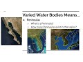
What is a peninsula?
A desert area with no vegetation
A mountain range with high peaks
A piece of land surrounded by water on three sides
A landform surrounded by water on all sides
6.
MULTIPLE CHOICE QUESTION
30 sec • 1 pt
Which of the following is an example of a peninsula?
The Korean Peninsula
The Amazon Rainforest
The Great Plains
The Sahara Desert
7.
MULTIPLE CHOICE QUESTION
30 sec • 1 pt
What is the significance of rivers in the Middle East and North Africa?
They are the primary source of desertification
They provide essential water resources for agriculture
They are used for mining and extraction
They are the main cause of earthquakes
Access all questions and much more by creating a free account
Create resources
Host any resource
Get auto-graded reports
Continue with Google

Continue with Email
Continue with Classlink
Continue with Clever
or continue with
Microsoft
%20(1).png)
Apple
Others
Already have an account?
