Measuring Trade Routes with a Compass
Interactive Video
•
Geography, Mathematics, Science
•
6th - 7th Grade
•
Practice Problem
•
Hard

Patricia Brown
FREE Resource
Read more
10 questions
Show all answers
1.
MULTIPLE CHOICE QUESTION
30 sec • 1 pt
What is the main task described in the introduction of the video?
Learning about the history of trade routes
Finding the shortest route to Bonampak
Calculating the cost of cotton goods
Completing question two for document A
2.
MULTIPLE CHOICE QUESTION
30 sec • 1 pt
Which of the following is NOT one of the three parts of question two?
Calculating the total distance
Determining the sea journey distance
Finding the cost of the journey
Calculating the land journey distance
3.
MULTIPLE CHOICE QUESTION
30 sec • 1 pt
What is the first step in locating the trade routes on the map?
Checking the map legend
Identifying the scale
Finding the sea trade routes
Locating the land trade routes
4.
MULTIPLE CHOICE QUESTION
30 sec • 1 pt
What tool is suggested for measuring distances on the map?
Protractor
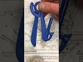
Compass
String
Ruler
5.
MULTIPLE CHOICE QUESTION
30 sec • 1 pt
How should the compass be set for accurate measurement?
At a random length
According to the map's scale
At the shortest possible length
At the longest possible length
6.
MULTIPLE CHOICE QUESTION
30 sec • 1 pt
What is the starting point for measuring the sea route?
Bonampak
Central America
Tulum
Yucatan Peninsula
7.
MULTIPLE CHOICE QUESTION
30 sec • 1 pt
What should you do if there is no visible route on the map?
Create a new route
Use an alternative map
Assume the route exists
Do not use that route
Access all questions and much more by creating a free account
Create resources
Host any resource
Get auto-graded reports
Continue with Google

Continue with Email
Continue with Classlink
Continue with Clever
or continue with
Microsoft
%20(1).png)
Apple
Others
Already have an account?
