Earthquake Location and Analysis
Interactive Video
•
Physics
•
9th - 10th Grade
•
Practice Problem
•
Hard

Patricia Brown
FREE Resource
Read more
10 questions
Show all answers
1.
MULTIPLE CHOICE QUESTION
30 sec • 1 pt
What is the primary purpose of using seismographs in earthquake studies?
To measure the temperature of the earth's core
To detect and record the movements of the earth during an earthquake
To predict weather patterns
To calculate the age of rocks
2.
MULTIPLE CHOICE QUESTION
30 sec • 1 pt
What is the first step in determining the location of an earthquake?
Finding the time difference between P and S waves
Drawing circles on a map
Using a compass to measure angles
Calculating the distance from the epicenter
3.
MULTIPLE CHOICE QUESTION
30 sec • 1 pt
How do you convert the time difference between P and S waves into seconds?
Multiply the minutes by 60 and add the seconds
Subtract the seconds from the minutes
Add the minutes and seconds together
Divide the minutes by 60 and subtract the seconds
4.
MULTIPLE CHOICE QUESTION
30 sec • 1 pt
What is the purpose of using a graph in the second step of earthquake location calculation?
To find the exact time of the earthquake
To convert time differences into distances
To measure the intensity of the earthquake
To predict future earthquakes
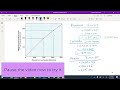
5.
MULTIPLE CHOICE QUESTION
30 sec • 1 pt
What is the distance from Panama to the earthquake according to the graph?
2100 kilometers
1600 kilometers
3100 kilometers
4000 kilometers
6.
MULTIPLE CHOICE QUESTION
30 sec • 1 pt
What tool can be used to draw accurate circles around the locations?
A ruler
A compass
A measuring tape
A protractor
7.
MULTIPLE CHOICE QUESTION
30 sec • 1 pt
Why is it important to draw circles around the locations in the final step?
To calculate the distance between cities
To measure the earthquake's magnitude
To find the intersection point indicating the earthquake's location
To determine the depth of the earthquake
Access all questions and much more by creating a free account
Create resources
Host any resource
Get auto-graded reports
Continue with Google

Continue with Email
Continue with Classlink
Continue with Clever
or continue with
Microsoft
%20(1).png)
Apple
Others
Already have an account?
Similar Resources on Wayground
Popular Resources on Wayground

15 questions
Fractions on a Number Line
Quiz
•
3rd Grade
20 questions
Equivalent Fractions
Quiz
•
3rd Grade
25 questions
Multiplication Facts
Quiz
•
5th Grade
29 questions
Alg. 1 Section 5.1 Coordinate Plane
Quiz
•
9th Grade
22 questions
fractions
Quiz
•
3rd Grade
11 questions
FOREST Effective communication
Lesson
•
KG
20 questions
Main Idea and Details
Quiz
•
5th Grade
20 questions
Context Clues
Quiz
•
6th Grade
Discover more resources for Physics
10 questions
Exit Check 4.1 - Destructive Processes
Quiz
•
9th Grade
10 questions
Exit Check 4.2 - Constructive Forces
Quiz
•
9th Grade
10 questions
Exit Check 4.3 - Conservation of Momentum
Quiz
•
9th Grade
10 questions
Exit Check 4.4 - Momentum Calculations
Quiz
•
9th Grade
21 questions
EM Spectrum
Quiz
•
6th - 9th Grade
20 questions
Simple Machines and Mechanical Advantage Quiz
Quiz
•
9th Grade
14 questions
Graphs of Motion, Velocity & Acceleration
Quiz
•
8th - 9th Grade
21 questions
PE & KE Practice
Quiz
•
8th - 11th Grade