Geographical Features and Water Bodies
Interactive Video
•
Geography
•
6th - 7th Grade
•
Practice Problem
•
Hard

Patricia Brown
FREE Resource
Read more
10 questions
Show all answers
1.
MULTIPLE CHOICE QUESTION
30 sec • 1 pt
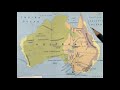
What geographical feature runs parallel to the eastern coast?
Great Dividing Range
Great Artesian Basin
Flinders Ranges
Mount Lofty Ranges
2.
MULTIPLE CHOICE QUESTION
30 sec • 1 pt
What should you use to represent the Great Artesian Basin on a map?
Red lines
Blue lines
Brown lines
Pencil shading
3.
MULTIPLE CHOICE QUESTION
30 sec • 1 pt
Which lakes are located near the Great Artesian Basin?
Lake Superior and Lake Michigan
Lake Baikal and Lake Ladoga
Lake Victoria and Lake Tanganyika
Lake Yamayama and Lake Erie
4.
MULTIPLE CHOICE QUESTION
30 sec • 1 pt
Which rivers flow towards Lake Yamayama and Lake Erie?
Yangtze, Yellow, and Mekong
River Nile, River Congo, and River Zambezi
Georgina, Dimensional, and Cooper's Creek
Amazon, Orinoco, and Paraná
5.
MULTIPLE CHOICE QUESTION
30 sec • 1 pt
What is important to include when drawing rivers on a map?
The color of the river
The depth of the river
The width of the river
The direction of flow
6.
MULTIPLE CHOICE QUESTION
30 sec • 1 pt
Which river and its tributaries flow southeast?
Amazon and its tributaries
River Murray, Murumbitki, and River Darling
Nile and its tributaries
Yangtze and its tributaries
7.
MULTIPLE CHOICE QUESTION
30 sec • 1 pt
What are the mountain ranges located below the Great Dividing Range?
Blue Mountains, Snowy, and Australian Alps
Alps and Pyrenees
Himalayas and Andes
Rocky Mountains and Sierra Nevada
Access all questions and much more by creating a free account
Create resources
Host any resource
Get auto-graded reports
Continue with Google

Continue with Email
Continue with Classlink
Continue with Clever
or continue with
Microsoft
%20(1).png)
Apple
Others
Already have an account?
