Map Projections and Their Characteristics
Interactive Video
•
Geography
•
9th - 10th Grade
•
Practice Problem
•
Hard

Patricia Brown
FREE Resource
Read more
10 questions
Show all answers
1.
MULTIPLE CHOICE QUESTION
30 sec • 1 pt
Why are maps considered a useful substitute for the real world?
They can show the entire planet at once.
They allow us to compute the actual size of features.
They eliminate the need for physical travel.
They provide a 3D view of the Earth.
2.
MULTIPLE CHOICE QUESTION
30 sec • 1 pt
What does a graphic scale on a map help with?
Understanding the Earth's rotation.
Visualizing the curvature of the Earth.
Calculating the volume of geographical features.
Directly comparing feature sizes and distances.
3.
MULTIPLE CHOICE QUESTION
30 sec • 1 pt
What is a representative fraction (RF) in map scales?
A statement comparing units on the map to units on Earth.
A graphic representation of distances.
A ratio between map distance and Earth distance.
A method to visualize map features.
4.
MULTIPLE CHOICE QUESTION
30 sec • 1 pt
How does the expanse of the real world shown on a map affect its geometric accuracy?
Larger areas increase accuracy.
Smaller areas decrease accuracy.
It has no effect on accuracy.
Larger areas decrease accuracy.
5.
MULTIPLE CHOICE QUESTION
30 sec • 1 pt
What happens when a plane is placed in contact with a sphere?
The surfaces merge without distortion.
The distance between surfaces remains constant.
The distance decreases with distance from the contact point.
The distance increases with distance from the contact point.
6.
MULTIPLE CHOICE QUESTION
30 sec • 1 pt
What is the first step in creating a map projection?
Reducing the Earth to a small globe.
Choosing a projection surface.
Flattening the globe.
Centering the projection on the area of interest.
7.
MULTIPLE CHOICE QUESTION
30 sec • 1 pt
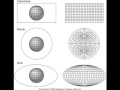
Which projection surfaces can be flattened without distortion?
Cone, sphere, and cylinder.
Cylinder, sphere, and plane.
Sphere, cone, and plane.
Cone, cylinder, and plane.
Access all questions and much more by creating a free account
Create resources
Host any resource
Get auto-graded reports
Continue with Google

Continue with Email
Continue with Classlink
Continue with Clever
or continue with
Microsoft
%20(1).png)
Apple
Others
Already have an account?
Popular Resources on Wayground

8 questions
Spartan Way - Classroom Responsible
Quiz
•
9th - 12th Grade
15 questions
Fractions on a Number Line
Quiz
•
3rd Grade
14 questions
Boundaries & Healthy Relationships
Lesson
•
6th - 8th Grade
20 questions
Equivalent Fractions
Quiz
•
3rd Grade
3 questions
Integrity and Your Health
Lesson
•
6th - 8th Grade
25 questions
Multiplication Facts
Quiz
•
5th Grade
9 questions
FOREST Perception
Lesson
•
KG
20 questions
Main Idea and Details
Quiz
•
5th Grade