
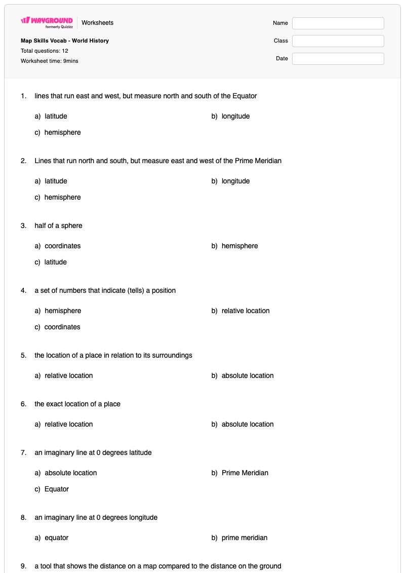

This Grade 6 Geography and Social Studies worksheet builds map-skills vocabulary through 12 multiple-choice questions. Students identify the meanings and uses of latitude, longitude, hemispheres, coordinates, relative location, absolute location, the Equator, the Prime Meridian, map scale, compass roses, cardinal directions, and intermediate directions.
As a free printable worksheet with an answer key, it gives teachers a focused way to check whether students can distinguish related mapping terms from concise definitions. The questions support introductory world geography and world history lessons by strengthening the vocabulary students need to describe location, direction, distance, and major reference lines on maps.
Worksheet settings
Font size
S
M
L
XL
Worksheets
Map Skills Vocab - World History
Total questions: 12
Name
Class
Date
1.
lines that run east and west, but measure north and south of the Equator
a)
latitude
b)
longitude
c)
hemisphere
2.
Lines that run north and south, but measure east and west of the Prime Meridian
a)
latitude
b)
longitude
c)
hemisphere
3.
half of a sphere
a)
coordinates
b)
hemisphere
c)
latitude
4.
a set of numbers that indicate (tells) a position
a)
hemisphere
b)
relative location
c)
coordinates
5.
the location of a place in relation to its surroundings
a)
relative location
b)
absolute location
6.
the exact location of a place
a)
relative location
b)
absolute location
7.
an imaginary line at 0 degrees latitude
a)
absolute location
b)
Prime Meridian
c)
Equator
8.
an imaginary line at 0 degrees longitude
a)
equator
b)
prime meridian
9.
a tool that shows the distance on a map compared to the distance on the ground
a)
map scale
b)
compass rose
c)
cardinal directions
10.
a circle showing the main directions
a)
compass rose
b)
map scale
c)
cardinal directions
11.
the main directions
a)
compass rose
b)
cardinal direcitons
c)
map scale
12.
the directions that are halfway between the cardinal direcitons
a)
cardinal directions
b)
map scale
c)
intermediate directions
Answer Key
Map Skills Vocab - World History
Total questions: 12
1.
a)
latitude
2.
b)
longitude
3.
b)
hemisphere
4.
c)
coordinates
5.
a)
relative location
6.
b)
absolute location
7.
c)
Equator
8.
b)
prime meridian
9.
a)
map scale
10.
a)
compass rose
11.
b)
cardinal direcitons
12.
c)
intermediate directions
140 %
Browse by subjects
Browse by grades
Browse by format
FAQs
What does this map-skills vocabulary worksheet cover?
This Grade 6 worksheet uses 12 multiple-choice definition questions to help students distinguish foundational map terms, including latitude and longitude, coordinates, relative and absolute location, the Equator and Prime Meridian, map scale, and directional vocabulary. Selecting the correct term for each definition builds the precise vocabulary students need to describe position, direction, and distance on maps.
How can I use this worksheet to teach map-skills vocabulary?
Introduce the terms in connected pairs before assigning the questions: latitude versus longitude, relative versus absolute location, and the Equator versus the Prime Meridian. After students complete the multiple-choice items, ask them to explain why a distractor does not fit—for example, why a compass rose shows directions while a map scale compares map distance with ground distance.
What mistakes should I watch for on this map-skills worksheet?
Students may confuse latitude with longitude, especially because both describe imaginary lines, or reverse which one measures north-south position and which measures east-west position. They may also mix up relative and absolute location, confuse the Equator with the Prime Meridian, or select compass rose, cardinal directions, and intermediate directions as if they were interchangeable.
How do I assign and grade this map-skills worksheet?
The worksheet is available as a printable PDF and as a digital quiz on Wayground, and it includes a complete answer key for all 12 multiple-choice questions. You can grade printable submissions by scanning student work with the Wayground for Teachers app, while the digital quiz provides an online assignment option.
How can I differentiate this map-skills vocabulary worksheet for my students?
Use the worksheet’s Advanced Settings to adjust font spacing and font size so the 12 definition-and-choice items are easier to scan. You can also apply a dyslexia-friendly font or translate the worksheet into another language, helping students access the map-skills vocabulary without changing the question format.
Where can I find more worksheets like this on Wayground?
Wayground offers a comprehensive collection of free printable worksheets and practice problems across all subjects, with downloadable PDFs and answer keys to support essential skills and concepts. Browse more resources at https://wayground.com/en-us/worksheets.