
20 Q
8th
15 Q
6th - Uni
15 Q
8th
10 Q
6th - 8th
10 Q
8th
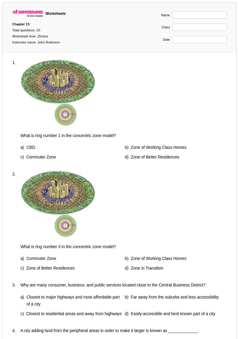
25 Q
7th - Uni
25 Q
7th - Uni
25 Q
6th - Uni
25 Q
6th - Uni
25 Q
6th - Uni
15 Q
5th - Uni
25 Q
8th - Uni
20 Q
8th
50 Q
6th - Uni
15 Q
8th
41 Q
6th - 9th
10 Q
8th
10 Q
8th
10 Q
8th - 12th
11 Q
8th

20 Q
25 Q
7th - Uni
Explore Geographical Boundaries Worksheets by Grades
Explore Other Subject Worksheets for class 8
Explore printable Geographical Boundaries worksheets for Class 8
Geographical boundaries worksheets for Class 8 students available through Wayground (formerly Quizizz) provide comprehensive exploration of political, physical, and cultural borders that define regions across the globe. These educational resources strengthen critical thinking skills as students analyze how mountains, rivers, and other natural features create physical boundaries, while examining the complex processes behind the formation of political borders between nations, states, and territories. The worksheets incorporate practice problems that challenge students to identify different types of boundaries on maps, understand the historical factors that influenced border creation, and evaluate the impact of geographical boundaries on human settlement patterns and economic development. Each worksheet includes detailed answer keys that support independent learning and allow students to verify their understanding of boundary classifications, from natural barriers to artificially constructed political divisions. These free printables offer structured activities that build spatial reasoning abilities and geographic literacy essential for advanced social studies coursework.
Wayground (formerly Quizizz) empowers educators with millions of teacher-created geographical boundaries worksheets specifically designed to meet Class 8 social studies standards and accommodate diverse learning needs in the classroom. The platform's advanced search and filtering capabilities enable teachers to quickly locate resources aligned with specific curriculum requirements, whether focusing on international borders, state boundaries, or the geographical factors that influence territorial divisions. Differentiation tools allow educators to customize worksheets for various skill levels, supporting both remediation for struggling students and enrichment opportunities for advanced learners who need additional challenge in analyzing complex boundary disputes and territorial changes over time. Available in both printable pdf format and interactive digital versions, these resources provide flexibility for lesson planning, homework assignments, and targeted skill practice sessions that reinforce understanding of how geographical boundaries shape political relationships, economic systems, and cultural interactions across different regions of the world.
FAQs
How do I teach geographical boundaries to students?
What exercises help students practice identifying types of geographical boundaries?
What common mistakes do students make when learning about geographical boundaries?
How do geographical boundaries connect to broader social studies concepts?
How can I use geographical boundaries worksheets in my classroom?
How can I support students with different learning needs when teaching geographical boundaries?