

Wayground
Caribbean South America - Printable Social Studies Worksheets - Wayground

Caribbean South America

20 questions

8th - 8th Grade

Social Studies

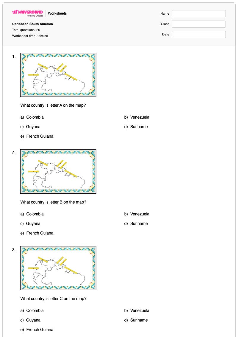
Caribbean South America is a free printable Grade 8 Social Studies worksheet that builds map-reading and regional geography skills. Students identify countries in Caribbean South America from labeled map locations, connect map labels with capital cities, identify the Equator’s relationship to Colombia, and recognize major geographic features shown on the map. The 20-question set includes 18 multiple-choice questions, one matching item, and one classification activity. This worksheet helps students distinguish political geography from physical geography while using map evidence to identify locations and relationships. It is suitable for introducing or reviewing the countries, capitals, latitude, and geographic features of the region in class, as independent practice, or as a quick assessment. The worksheet is available as a free printable PDF and includes a complete answer key for efficient checking and feedback.

Worksheet settings

Font size

S
M
L
XL
Worksheets

Caribbean South America

Total questions: 20

Name
Class
Date
1.

What country is letter A on the map?

a)

Colombia

b)

Venezuela

c)

Guyana

d)

Suriname

e)

French Guiana

2.

What country is letter B on the map?

a)

Colombia

b)

Venezuela

c)

Guyana

d)

Suriname

e)

French Guiana

3.

What country is letter C on the map?

a)

Colombia

b)

Venezuela

c)

Guyana

d)

Suriname

e)

French Guiana

4.

What country is letter D on the map?

a)

Colombia

b)

Venezuela

c)

Guyana

d)

Suriname

e)

French Guiana

5.

What country is letter E on the map?

a)

Colombia

b)

Venezuela

c)

Guyana

d)

Suriname

e)

French Guiana

6.

What capital is located at Letter A

a)

Bogota

b)

Caracas

c)

Georgetown

d)

Paramaribo

e)

Cayenne

7.

What capital is located at Letter B

a)

Bogota

b)

Caracas

c)

Georgetown

d)

Paramaribo

e)

Cayenne

8.

What capital is located at Letter C

a)

Bogota

b)

Caracas

c)

Georgetown

d)

Paramaribo

e)

Cayenne

9.

What capital is located at Letter D

a)

Bogota

b)

Caracas

c)

Georgetown

d)

Paramaribo

e)

Cayenne

10.

What capital is located at Letter E

a)

Bogota

b)

Caracas

c)

Georgetown

d)

Paramaribo

e)

Cayenne

11.

What major line of latitude runs through Colombia in South America?

a)

Tropic of Cancer

b)

Equator

c)

Tropic of Capricorn

d)

Prime Meridian

12.

What geographic feature is found at Letter A on the map

a)

Pacific Ocean

b)

Andes Mountains

c)

Caribbean Sea

d)

Orinoco River

e)

Atlantic Ocean

13.

What geographic feature is found at Letter B on the map

a)

Pacific Ocean

b)

Andes Mountains

c)

Caribbean Sea

d)

Orinoco River

e)

Atlantic Ocean

14.

What geographic feature is found at Letter C on the map

a)

Pacific Ocean

b)

Andes Mountains

c)

Caribbean Sea

d)

Orinoco River

e)

Atlantic Ocean

15.

What geographic feature is found at Letter D on the map

a)

Pacific Ocean

b)

Andes Mountains

c)

Caribbean Sea

d)

Orinoco River

e)

Atlantic Ocean

16.

What geographic feature is found at Letter E on the map

a)

Pacific Ocean

b)

Andes Mountains

c)

Caribbean Sea

d)

Orinoco River

e)

Atlantic Ocean

17.

Match the following places with the correct description

Llanos

grassland found in South America

Tepuis

sandstone resistant to erosion

Andes Mountains

longest mountain system in the world

Angels Falls

world's highest waterfall

18.

Organize these facts between Climate and Resources

Categorize the following

located near equator impacts temperatures

lots of rain and vegetation due to location

height of elevation impacts it

rice, coffee, sugarcane, and bananas

oil

timber

Climate
Resources
19.

What country is EAST of Suriname on the map?

a)

Colombia

b)

Venezuela

c)

Guyana

d)

French Guiana

20.

What country is WEST of Venezuela on the map?

a)

Colombia

b)

Venezuela

c)

Guyana

d)

French Guiana

Answer Key

Caribbean South America

Total questions: 20

1.
a)

Colombia

2.
c)

Guyana

3.
e)

French Guiana

4.
d)

Suriname

5.
b)

Venezuela

6.
c)

Georgetown

7.
a)

Bogota

8.
b)

Caracas

9.
e)

Cayenne

10.
d)

Paramaribo

11.
b)

Equator

12.
b)

Andes Mountains

13.
c)

Caribbean Sea

14.
a)

Pacific Ocean

15.
e)

Atlantic Ocean

16.
d)

Orinoco River

17.

Llanos

 - 

grassland found in South America

, 

Tepuis

 - 

sandstone resistant to erosion

, 

Andes Mountains

 - 

longest mountain system in the world

, 

Angels Falls

 - 

world's highest waterfall

18.
Climate

located near equator impacts temperatures

lots of rain and vegetation due to location

height of elevation impacts it

Resources

rice, coffee, sugarcane, and bananas

oil

timber

19.
d)

French Guiana

20.
a)

Colombia

FAQs

What does the Caribbean South America worksheet cover?

This Grade 8 Social Studies worksheet uses labeled-map questions to assess students’ ability to identify Caribbean South American countries, associate map locations with capital cities, recognize the Equator’s relationship to Colombia, and identify physical features. Its 20 items combine 18 multiple-choice questions with one matching activity and one classification activity, requiring students to interpret map labels and sort geographic information.

How can I use this worksheet to teach Caribbean South American geography?

Introduce the worksheet by having students separate the map information into political geography—countries and capitals—and physical geography, including latitude and land or water features. Work through a few labeled-map items together, asking students to explain how the map location supports each answer, then assign the remaining multiple-choice, matching, and classification items for guided or independent practice. Review errors by asking students to compare a country, its capital, and the nearby geographic feature rather than memorizing isolated names.

What mistakes should I watch for when students complete this Caribbean South America worksheet?

Students may confuse the country-identification items with the capital-city items because both use lettered map locations and overlapping answer choices. They may also select a nearby country or capital without checking the label’s position, or confuse a line of latitude with a physical feature when answering the Equator question. During review, have students explain whether each answer names a country, capital, latitude line, or geographic feature, and check that their matching and classification choices follow the same categories.

How do I assign and grade this Caribbean South America worksheet?

Wayground provides this worksheet as both a printable PDF and a digital quiz, with a complete answer key for all 20 items. Assign the digital quiz for online responses, or print the map-based worksheet for paper practice; printable submissions can be graded by scanning student work with the Wayground for Teachers app. The printable format can also support schools that are reducing screen time.

How can I differentiate this Caribbean South America worksheet for my students?

Use the worksheet’s Advanced Settings to adjust font spacing and font size so the labeled-map questions, answer choices, matching item, and classification activity are easier to read. You can also enable a dyslexia-friendly font or translate the worksheet into another language when those options support access to the geography vocabulary and directions. Keep the map labels and response categories visible while adjusting the worksheet format.

Where can I find more worksheets like this on Wayground?

Wayground offers a broad collection of free printable worksheets and practice problems across subjects, with downloadable PDFs and answer keys to help students master essential skills and concepts. Browse more resources at https://wayground.com/en-us/worksheets.