
 Worksheets
U.S. & Canada Geography
Total questions: 35
Worksheet time: 18mins
Name
Class
Date
1.

This ocean sits off the West Coast of North America
a)
Atlantic
b)
Pacific
c)
Arctic
2.
This archipelago exists off the coast of Alaska
a)
Hawaiian Islands
b)
Aleutian Islands
c)
Ocracoke Islands
d)
Chincoteague Islands
3.

This river (the purple one in the picture) forms the boundary between the states of Washington and Oregon.
a)
Colorado River
b)
Columbia River
c)
Rio Grande
d)
Mississippi River
4.
Which city has the largest population and economy in Canada?
a)
Ottawa
b)
Montreal
c)
Quebec
d)
Toronto
5.
Which city has the largest population and economy in the United States, making a center for world's financial markets?
a)
New York City
b)
Los Angeles
c)
Chicago
d)
Houston
6.

The Gateway Arch is located in which city?
a)
Kansas City, Kansas
b)
New York City, New York
c)
St. Louis, Missouri
d)
Seattle, Washington
7.

The Golden Gate Bridge when finished in the early 1900's was the largest suspension bridge ever built. Where is it located?
a)
San Francisco, California
b)
San Diego, California
c)
Sacramento, California
d)
New York City, New York
8.

The longest river in North America is the __________. Which begins in northern Minnesota and empties into the Gulf of Mexico near New Orleans.
a)
Mississippi River
b)
Rio Grande
c)
St. Lawrence River
d)
Colorado River
9.

Which landform in the United States pictured here is most closely identified with the following characteristics: frost-free winters, humid summers, agriculture, broad harbors, and fishing?
a)
Great Plains
b)
Canadian Shield
c)
Atlantic and Gulf Coast Plains
d)
Rocky Mountains
10.

Which of the following cities is a growing Sun-belt city in Texas (in red on this map)?
a)
Houston
b)
Atlanta
c)
Sacramento
d)
Omaha
11.
An increase in the amount of passenger cars and trucks over time demonstrates the U.S. reliance on the growth of
a)
city centers
b)
airline travel
c)
commuter railways
d)
road construction
12.

These bodies of water are known as:
a)
Hudson Bays
b)
Great Lakes
c)
Large Ponds
d)
Small Oceans
13.
A large portion of the of the jobs, economy, and people in the United States are leaving the Rust Belt region (around Chicago, Detroit, Pittsburgh, and New York City) and heading to:
a)
New England
b)
The Pacific Northwest
c)
The Sun Belt
d)
The Great Plains
14.

Which mountain range is in the eastern part of the United States
a)
Appalachian Mountains
b)
Rocky Mountains
c)
Pacific Coastal Ranges
d)
Andes Mountains
15.
Which area sits between the Appalachian Mountains and the Great Plains
a)
Basin and Range
b)
Atlantic and Gulf Coast Plains
c)
Interior Lowlands/Central Lowlands/Mississippi Valley
d)
Grand Canyon
16.

What major Canadian city is found on the west coast of Canada, is a major port city, and has a diverse population (marked with a pin and the letter "A" on this map)?
a)
Omaha
b)
Ottawa
c)
Quebec
d)
Vancouver
17.
What major Canadian city can be found in the eastern part of Canada?
a)
Toronto
b)
Vancouver
c)
Winnipeg
d)
Halifax
18.

This region is a flat, grassy area in the middle of North America, also known as the breadbasket of North America.
a)
Mississippi Valley
b)
Great Plains
c)
Coastal Plains
d)
Canadian Shield
19.

This building is located in Washington, D.C. and is the home of the U.S. legislative branch.
a)
The White House
b)
The U.S. Capitol Building
c)
The Lincoln Memorial
d)
The Virginia Capitol Building
20.

This river provides water and electricity for the SW U.S. and N.W. Mexico including states like Nevada and Arizona
a)
Mississippi River
b)
Colorado River
c)
Columbia River
d)
St. Lawrence River
21.
Canada, U.S. and Mexico have an agreement called _________, which aims to make their economies better by eliminating trade barriers and tariffs.
a)
NAFTA
b)
NATO
c)
EU
d)
ACLU
22.
Which of the following has NOT been a way that the automobile has influenced the U.S.
a)
Motels
b)
Drive-up services
c)
Interstate highways
d)
Bilingual Signs
23.

What is the longest mountain chain in North America, covering an area all the way from Mexico and Alaska?
a)
Rocky Mountains
b)
Olympic Mountains
c)
Appalachian Mountains
d)
Sierra Nevadas
24.

The Declaration of Independence was signed in this building in Philadelphia, Pennsylvania
a)
White House
b)
Washington Monument
c)
Independence Hall
d)
Virginia Declaration of Rights
25.
U.S. and Canada were colonized by:
a)
Africans
b)
Asians
c)
Australians
d)
Europeans
26.

This landmass surrounds the Hudson Bay:
a)
Canadian Shield
b)
Horseshoe Rock
c)
Coastal Ranges
d)
Coastal Plains
27.

The Rocky Mountains are also known as this __________, which means it divide two watersheds and force all water to the west to end up in the Pacific Ocean and all water to the east to end up in the Atlantic.
a)
Continental Divide
b)
Great Basin
c)
Columbia Plateau
d)
Central Highlands
28.
Canada and the United States share all the following economic characteristics EXCEPT:
a)
Highly diversified economies
b)
Major importers of technology
c)
Highly developed infrastructures
d)
Rich supply of mineral, energy, and forest resources
29.
Which region falls between the Rocky Mountains and the Central (Interior) Lowlands?
a)
Appalachian Mountains
b)
Coastal Plains
c)
Great Plains
d)
Basin and Range
30.

This ocean sits off the East Coast of North America
a)
Atlantic
b)
Pacific
c)
Arctic
31.

Which landmass in the U.S. contains Death Valley, and is the lowest elevation point in the U.S. (colored in green on map)?
a)
Basin and Range
b)
Appalachian Mountains
c)
Coastal Range
d)
Great Plains
32.

Which body of water is surrounded by the red area on this map?
a)
Hudson Bay
b)
Great Lakes
c)
Gulf of Mexico
d)
Gulf of Canada
33.
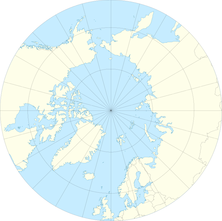
Which ocean sits completely north of Canada and the U.S.?
a)
Arctic Ocean
b)
Atlantic Ocean
c)
Indian Ocean
d)
Pacific Ocean
34.
The negative impact of using coal and oil in the U.S. and Canada is -
a)
environmental
b)
political
c)
cultural
d)
economic
35.
Which Canadian province contains the majority of French-speaking Canadians?
a)
Quebec
b)
Nova Scotia
c)
New Brunswick
d)
British Columbia
100 %

