
 Worksheets
Political and Physical Features of Europe
Total questions: 38
Worksheet time: 31mins
Name
Class
Date
1.

This acts as the boundary between Europe and Asia
a)
Ural Mountains
b)
Appalachian Mountains
c)
Pyrenees Mountains
d)
Alps
2.

Largest land-form in Europe which has lots of arable land (land good for farming)
a)
Central uplands
b)
North European Plan
c)
Alpine mountain system
d)
British Islands
3.
The ______________________ Mountains form the border between France and Spain.
a)
Alps
b)
Pyrenees
c)
Ural
d)
Rhine
4.
The _______________________ Mountains are the dividing line between Europe and Asia.
a)
Alps
b)
Pyrenees
c)
Ural
d)
Danube
5.
The _______________________ Mountains run through Germany, Switzerland, and Austria.
a)
Alps
b)
Pyrenees
c)
Ural
d)
Mediterranean
6.
What countries are located on the Iberian Peninsula?
a)
Denmark and Germany
b)
U.K. and Ireland
c)
Spain and Portugal
d)
Norway and Sweden
7.
The second-longest river of Europe. It flows from southern Germany east into the Black Sea.
a)
Danube
b)
Rhine
c)
Tigris
d)
Nile
8.
The _____________________ River is the longest river in western Europe and flows from Germany to the Black Sea
a)
Danube
b)
Rhine
c)
Alps
d)
English Channel
9.
The _____________________ Peninsula is in southern Europe near the Mediterranean Sea.
a)
Scandinavian
b)
Iberian
c)
Alps
d)
Pyrenees
10.
Because Europe borders two oceans and has many seas, rivers and canals makes it a leader in the ___________________ industry.
a)
car manufacturing
b)
shipping
c)
cosmetics
d)
toy manufacturing
11.
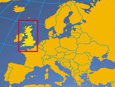
Which country is this?
a)
Ireland
b)
Iceland
c)
Portugal
d)
United Kingdom
12.
Why are the Danube and Rhine rivers important?
a)
They can be used easily for shipping goods (trade)
b)
they run along mountain chains
c)
they serve as borders between countries
d)
they support agriculture and wildlife
13.

Which country is this?
a)
Germany
b)
Poland
c)
Spain
d)
Ukraine
14.
The river in Western Europe that flows into the North Sea is the _____________ River.
a)
Rhine
b)
Danube
c)
Nile
d)
Chattahoochee
15.

What physical feature is this?
a)
Atlantic Ocean
b)
Strait of Gibraltar
c)
English Channel
d)
Mediterranean Sea
16.

What physical feature is this?
a)
Atlantic Ocean
b)
Strait of Gibraltar
c)
English Channel
d)
Mediterranean Sea
17.

What physical feature is this?
a)
Balkan Peninsula
b)
Italian Peninsula
c)
Iberian Peninsula
d)
Scandinavian Peninsula
18.

Which country is labeled 26?
a)
Ukraine
b)
Poland
c)
France
d)
UK
19.

Which country is labeled 20?
a)
Italy
b)
France
c)
Poland
d)
Spain
20.

Which country is labeled 18?
a)
Germany
b)
Poland
c)
Ukraine
d)
Italy
21.

Which country is labeled 2?
a)
UK
b)
Belgium
c)
Italy
d)
Germany
22.

Which country is labeled 6?
a)
France
b)
UK
c)
Russia
d)
Germany
23.

Which country is labeled 5?
a)
Spain
b)
UK
c)
Italy
d)
France
24.

Which feature does the picture represent?
a)
Atlantic Ocean
b)
Mediterranean Sea
c)
English Channel
d)
Pacific Ocean
25.

Which feature does the picture represent?
a)
English Channel
b)
Rhine River
c)
Danube River
d)
Atlantic Ocean
26.

Which feature does the picture represent?
a)
Ural Mountains
b)
European Plain
c)
Alps
d)
Scandinavian Peninsula
27.

Which feature does the picture represent?
a)
Mediterranean Sea
b)
Atlantic Ocean
c)
English Channel
d)
Danube River
28.
The ______________ is located between United Kingdom and France.
a)
Mediterranean Sea
b)
English Channel
c)
Rhine River
d)
Atlantic Ocean
29.
What forms the natural border between Spain and France? (divides Spain and France)
a)
Pyrenees
b)
Alps
c)
Mediterranean Sea
d)
English Channel
30.
What extends from France to the Ural Mountains and in very important to Europe's agriculture (farming)?
a)
Scandinavian Peninsula
b)
Mediterranean Sea
c)
European Plain
d)
Ural Mountains
31.
This landform separates Europe from Africa and is a huge tourist attraction for Europe.
a)
English Channel
b)
Ural Mountains
c)
Mediterranean Sea
d)
Atlantic Ocean
32.
What is the 2nd largest peninsula in Europe?
a)
Scandinavian Peninsula
b)
Iberian Peninsula
c)
European Plain
d)
Pyrenees
33.
What mountains separate Europe and Asia?
a)
Ural
b)
Pyrenees
c)
Alps
d)
Appalachian
34.

What physical feature is pictured?
a)
Danube River
b)
Aral Sea
c)
Alps
d)
Pyrenees
35.

What physical feature is pictured?
a)
Danube River
b)
Aral Sea
c)
Alps
d)
Pyrenees
36.

What physical feature is pictured?
a)
Siberia
b)
Baltic Sea
c)
Ural Mountains
d)
Lake Baikal
37.

What physical feature is pictured?
a)
North Sea
b)
Volga River
c)
Rhine River
d)
Strait of Gibraltar
38.
Which country lies in both Europe and Asia?
a)
Rome
b)
Russia
c)
Italy
d)
Ukraine
100 %

