
 Worksheets
Map Skills
Total questions: 34
Worksheet time: 3hrs 52mins
Name
Class
Date
1.
What divides the globe into northern and southern hemispheres?
a)
Prime Meridian
b)
Hemispheres
c)
Equator
2.
What divides the Earth into western and eastern hemispheres?
a)
Prime Meridian
b)
Regions
c)
Hemispheres
3.

What continent is this?
a)
Africa
b)
Virginia
c)
North America
d)
Staunton
4.

What is this?
a)
key
b)
title
c)
compass rose
d)
star
5.
What continent do you live on?
a)
South America
b)
Virginia
c)
United States
d)
North America
6.
What is a round model of the Earth called?
a)
Globe
b)
Map
c)
Continent
d)
GPS
7.

Name the part of the map labeled with "A."
a)
Key
b)
Title
c)
Compass Rose
8.

Name the part of the map labeled with a "B."
a)
Key
b)
Title
c)
Compass Rose
9.

Name the part of the map labeled with a "C."
a)
Key
b)
Title
c)
Compass Rose
10.

What does the red line in the picture show?
a)
Prime Meridian
b)
Equator
c)
continents
d)
countries
11.

What does the red line in the picture show?
a)
Prime Meridian
b)
Equator
c)
Continents
d)
Countries
12.
If you wanted to know the symbol for "river," where on a map would you look?
a)
the scale
b)
the compass rose
c)
the borders
d)
the legend
13.
What is the map scale used to figure out?
a)
the number of countries shown on the map
b)
which direction is north, south, east and west
c)
the real distance between places on the map
d)
what the map symbols mean
14.
If you wanted to know which direction you’d have to travel to get from New York to Philadelphia, where on a map would you look?
a)
the scale
b)
the compass rose
c)
the border
d)
the legend
15.

What are these lines known as ?
a)
latitude
b)
relative location
c)
longitude
d)
absolute location
16.

What are these lines known as?
a)
latitude
b)
longitude
c)
relative location
d)
absolute location
17.
This type of map shows cities, states, and countries
a)
physical map
b)
political map
c)
historical map
18.
This type of map shows kinds of land and bodies of water
a)
Physical map
b)
political map
c)
historical map
19.
Latitude and Longitude are measured in ________.
a)
inches
b)
feet
c)
degrees
d)
grams
20.

What type of map is this?
a)
Political
b)
Physical
c)
Economic Activity
d)
Population
21.
Lines of longitude are called this.
a)
meridian
b)
parallel
c)
equator
d)
longitude
22.
NE, SE, NW, SW are these type of directions.
a)
cardinal
b)
intermediate
c)
main
d)
subterrain
23.
Lines of latitude are called this.
a)
tropic zone
b)
parallel
c)
polar zone
d)
meridian
24.
Where would you find the symbol that indicates which city on the map is the capital city?
a)
map scale
b)
map legend
c)
map elevation
d)
map title
25.
If you wanted to know the symbol for "river," where on a map would you look?
a)
the scale
b)
the compass rose
c)
the borders
d)
the legend
26.
What kind of map shows us the borders of countries and the names of countries or states?
a)
political map
b)
physical map
c)
economic activity map
d)
vegetation map
27.

Maps use ______ that stand for things that are drawn on a map.
a)
symbols
b)
scales
c)
routes
d)
titles
28.

One of 4 directions that are midway between the cardinal directions.
a)
Intermiddle directions
b)
Mediate directions
c)
Intermediate directions
d)
Cardinal directions
29.
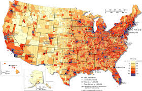
Identify this map.
a)
Population density map
b)
Zoning map
c)
Road map
d)
Physical map
30.

Identify this map
a)
Physical Map
b)
Climate Map
c)
Road Map
31.
How do you know what the map is all about?
a)
Read the title
b)
Look at the map key
c)
Look at the compass rose
32.
What tells us the directions on a map?
a)
Title
b)
Mrs. Edwards
c)
Compass Rose
33.

What street is the car driving on?
a)
Oak Street
b)
First Street
c)
Second Street
34.

Where is the lake?
a)
in the mountains
b)
In the forest
c)
On the railroad
100 %

