
 Worksheets
Weather Study Guide
Total questions: 41
Worksheet time: 30mins
Name
Class
Date
1.
When the ______ is 50%, the air contains 50% of the water needed for the air to be saturated.
a)
relative humidity
b)
humidity
c)
front
d)
dew point
2.
When water is cooled to its dew point, it forms a cloud on the ground called _____.
a)
cumulus
b)
precipitation
c)
fog
d)
condensation
3.
Rain, snow, sleet, and hail are all forms of _____.
a)
precipitation
b)
condensation
c)
evaporation
d)
climate
4.

A violently rotating column of air called a _____ when it comes in contact with the ground.
a)
hurrican
b)
tornado
c)
trade wind
d)
local wind
5.

A(n) _____ is a large body of air that has properties similar to the part of Earth's surface over which it depends.
a)
tornado
b)
pressure system
c)
front
d)
air mass
6.

When two air masses meet, there is a _____, or boundary.
a)
thunderstorm
b)
watch
c)
front
d)
cloud
7.

A _____ is a large, swirling, low-pressure system that forms over the Atlantic Ocean.
a)
blizzard
b)
cold front
c)
tornado
d)
hurricane
8.

A(n) ____ is a line that connects points of equal temperatures on a weather map.
a)
station model
b)
occluded front
c)
isotherm
d)
isobar
9.

A _____ is a person who studies the weather.
a)
meteorologist
b)
geologist
c)
weatherologist
d)
hydrologist
10.
What role do oceans play in hurricane formation?
a)
they provide cool, dense water
b)
warm water supplies energy to hurricanes
c)
warm ocean water slows hurricane formation
d)
cold ocean water supplies energy to hurricanes
11.
____________ air rises because it is ____________dense.
a)
Cool, Less
b)
Warm, Less
c)
Cold, More
d)
Warm, More
12.
What kind of weather is usually associated with a high pressure system?
a)
Sunny weather
b)
Precipitation (rain, snow, etc.)
13.

What does this symbol indicate on a weather map?
a)
High pressure system
b)
Low pressure system
c)
Cold front
d)
Warm front
14.

What does this symbol on a weather map indicate?
a)
High pressure system
b)
Low pressure system
c)
Cold front
d)
Warm front
15.
What air mass develops along the Gulf of Mexico?
a)
continental polar
b)
maritime polar
c)
continental tropical
d)
maritime tropical
16.

name this front
a)
warm front
b)
cold front
c)
stationary front
d)
occluded front
17.
In a sea breeze, the air is warmer above the _____.
a)
land
b)
ocean
c)
sky
d)
beach
18.
Which air mass in the U.S comes from directly north and is typically cold and dry?
a)
continental polar
b)
maritime polar
c)
continental tropical
d)
maritime tropical
19.

What does this symbol on a weather map indicate?
a)
High pressure system
b)
Low pressure system
c)
Cold front
d)
Warm front
20.
What kind of weather is usually associated with a high pressure system?
a)
Sunny weather
b)
Precipitation (rain, snow, etc.)
21.

What does this symbol on a weather map indicate?
a)
High pressure system
b)
Low pressure system
c)
Cold Front
d)
Warm Front
22.

This weather tool is used to measure...
a)
Rainfall
b)
Wind Direction
c)
Wind Speed
d)
Temperature
23.
This type of severe weather causes heavy flooding, high winds, and storm surge.
a)
Tornado
b)
Hurricane
c)
Blizzard
d)
Thunderstorm
24.
The effects of this type of severe weather include buildings and trees being torn apart by high winds, and a path of destruction.
a)
Hurricane
b)
Tornado
c)
Blizzard
d)
Thunderstorm
25.

Identify the type of front that is shown in the image.
a)
Occluded Front
b)
Cold Front
c)
Stationary Front
d)
Warm Front
26.
The ozone layer protects us from
a)
UV rays
b)
CFCs
c)
Increased atmospheric heat
d)
Decreased atmospheric heat
27.

The amount of water vapor present in the air is called ________________.
a)
weather
b)
humidity
c)
air mass
d)
dew point
28.
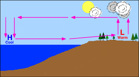
Is this a land or a sea breeze?
a)
land breeze
b)
sea breeze
29.
This weather tool measures wind speed and direction
a)
thermometer
b)
barometer
c)
anemometer
d)
psychrometer
30.
Where the warm and cold air meet and stall, clouds and fog form, and it may rain or snow. It could bring many days of clouds and precipitation.
a)
Warm Front
b)
Cold Front
c)
Occluded Front
d)
Stationary Front
31.
Air pressure is greatest:
a)
closer to Earth
b)
farther from Earth
32.
Warm air moving upwards from the Gulf of Mexico is:
a)
continental tropical
b)
continental polar
c)
maritime tropical
d)
maritime polar
33.
This means that the conditions are right for severe weather
a)
watch
b)
warning
34.
what are isobars?
a)
lines connecting places of equal temperature
b)
lines drawn connecting places of equal pressure
c)
lines drawn to places of different temperatures
d)
lines drawn to places of different pressures
35.

What direction is the cold front moving?
a)
Northwest
b)
Southeast
c)
Northeast
d)
Southwest
36.

The cold front is moving
a)
east and southeast
b)
west and northwest
c)
north
d)
south
37.

What kind of front is shown?
a)
cold
b)
warm
c)
stationary
d)
occluded
38.
A cold front moving into an area can bring this type of weather...
a)
Warmer Temperatures, Clear Skies
b)
Colder Temperatures, Clear Skies
c)
Warmer Temperatures, Clouds
d)
Colder Temperatures, Clouds, and Precipitation
39.

What front is moving through
Alabama and Georgia?
Alabama and Georgia?
a)
Warm
b)
Occluded
c)
Stationary
d)
Cold
40.

The heat from a hot burner to a pot is transferred by ______.
a)
convection
b)
insulation
c)
radiation
d)
conduction
41.
Where you will find the ozone layer.
a)
stratosphere
b)
thermosphere
c)
exosphere
d)
mesosphere
100 %

