
 Worksheets
Geology
Total questions: 40
Worksheet time: 31mins
Name
Class
Date
1.

What is the most likely elevation of the mountain below?
a)
774 meters
b)
871 meters
c)
922 meters
d)
985 meters
2.
Deep cracks in the Earth's crust.
a)
faults
b)
tear
c)
twist
d)
shear
3.
A collision between two pieces of continental crust at a converging boundary produces a
a)
mid ocean ridge
b)
deep ocean trench
c)
rift valley
d)
mountain range
4.

What is happening at Z?
a)
mid-ocean ridge
b)
subduction zone
c)
transform boundary
d)
sea floor spreading
5.

Which type of plate boundary occurs at Y?
a)
divergent
b)
convergent
c)
transform
d)
sea floor spreading
6.
What is the theory of continental drift?
a)
the continents move slowly over Earth's surface
b)
continents moved millions of years ago but are now fixed
c)
the continents were once fixed, but have just now begun to move
d)
the continents are fixed in position
7.

What is the map symbol (darker lines)?
a)
roads
b)
index contour
c)
contour interval
d)
waves
8.

Determine the contour interval
a)
10 m
b)
20 m
c)
50 m
d)
100 m
9.
What type of boundary creates new seafloor?
a)
convergent ocean ocean
b)
convergent ocean continental
c)
convergent continental continental
d)
divergent
10.
What type of boundary creates a mountain chain?
a)
convergent ocean ocean
b)
convergent ocean continental
c)
convergent continental continental
d)
divergent
11.
The Himalayan mountains are in the middle of a continent, what boundary creates them?
a)
transform
b)
convergent ocean continental
c)
convergent continental continental
d)
convergent ocean ocean
12.
Which of the following occurs because of convection currents?
a)
Tectonic plates on the crust move.
b)
The mantle increases in size.
c)
Pressure in the crust increases.
d)
Pressure in the crust decreases.
13.
Where does the heat come from that drives this convection current in the mantle?
a)
The sun
b)
The crust
c)
the mantle
d)
the core
14.
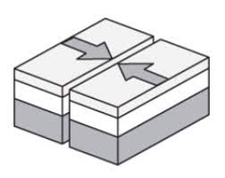
Name the boundary
a)
convergent boundary
b)
divergent boundary
c)
transform boundary
d)
sergent boundary
15.

Name the boundary
a)
convergent boundary
b)
divergent boundary
c)
transform boundary
d)
sergent boundary
16.
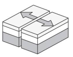
Name the boundary
a)
convergent boundary
b)
divergent boundary
c)
transform boundary
d)
sergent boundary
17.
A subduction zone is formed...
a)
when one tectonic plate sinks below another
b)
at every type of convergent plate boundary
c)
at every type of divergent plate boundary
d)
at transform boundaries
18.
Whenever a subduction zone is formed a ______ is formed.
a)
Mountain
b)
Island Arc
c)
Rift
d)
Volcano
19.
Plate movement is caused by ______________.
a)
the rotation of the Earth
b)
ocean tides
c)
convection currents in the mantle
d)
the moon's gravity
20.

In which direction is Mill River flowing?
a)
Southeast
b)
Southwest
c)
Northeast
d)
Northwest
21.

Which side of Holland Hill is the steepest?
a)
North
b)
South
c)
East
d)
West
22.

Which topographic map matches formation C?
a)
1
b)
2
c)
3
d)
4
23.
Fault
a)
Convergent
b)
Divergent
c)
Transform
d)
none
24.

What is this a satellite image of?
a)
Desert
b)
Mountain
c)
Delta
d)
Lake
25.

What is this a satellite image of?
a)
Desert
b)
Delta
c)
River
d)
Canyon
26.

What process is causing the V-shape in the picture?
a)
Deposition
b)
Weathering and erosion
27.

What is this a topographic map of?
a)
A gentle rolling plain with a river running through it.
b)
A canyon with steep walls.
28.

Which area has experienced the greatest amount of erosion?
a)
A
b)
B
c)
C
d)
D
29.

What kind of area is this?
a)
Plains
b)
Canyon
30.

How do the arrows on the contour lines help us know in which a creek or river flows?
a)
The arrows point in the direction of flow
b)
The arrows point in the opposite direction of flow
c)
The arrows tell the elevation, not the direction of flow
31.

Walking from point A to point B...
a)
You would walk up 10 m, then down 25 m, then up 45 m
b)
You would walk up 40 m, then down 60 m, then up 100 m
c)
You would walk at the same elevation 90 m
d)
You would walk down to the Creek, then up 50 m to the top of Holland Hill
32.

A mountaineer is planning an expedition. He wants to follow the easiest possible path, which means he needs to find the most gentle slope up the mountain. Which route should the mountaineer choose?
a)
Route A
b)
Route B
c)
Route C
d)
Route D
33.

What is the change in elevation from point X to the top of the hill in the topographic map shown?
a)
303 m
b)
203 m
c)
250 m
d)
253 m
34.
What process created this canyon?
a)
Divergent Boundary
b)
Erosion and weathering from the river
c)
Convergent Boundary
d)
Deposition
35.

What is the elevation of the peak of the small island on the left side?
a)
About 20 meters
b)
About 40 meters
c)
About 60 meters
d)
About 200 meters
36.
Which evidence was not used by Wegener to support his continental drift theory?
a)
South America & Africa coastlines
b)
Climate evidence
c)
Plant & reptile fossils
d)
Earthquake patterns
37.
Wegener compiled more evidence to support his theory but did not use this one:
a)
Fossil evidence
b)
climate evidence
c)
lava samples
d)
mountain ranges
38.
Wegener's evidence supports his theory of a super continent that he named?
a)
Ultima
b)
Pangaea
c)
Plate Tectonics
d)
Continental Drift
39.
Divergent
a)
collide
b)
divide
c)
slide past each other
d)
none
40.
convergent
a)
collide
b)
divide
c)
slide past each other
d)
none
100 %

