
 Worksheets
Plate Tectonics, Crustal Features, Maps, and Watershed
Total questions: 25
Worksheet time: 28mins
Name
Class
Date
1.

What would be the most likely way this coastline would change over time?
a)
A fire could destroy the vegetation
b)
The waves could erode the beach
c)
The beach would grow due to deposition
d)
The beach will disappear due to plate tectonics
2.

These images compare the same stretch of coastline. What is a possible reason for the change?
a)
A fire destroyed the beach and surrounding area
b)
Overtime, water eroded away much of the land
c)
A major catastrophe such as a hurricane or tsunami destroyed the area
d)
The beach and land went through a sever drought
3.

Provided is a topographic map of a hill with contour lines drawn showing elevation in meters.
The steepest slope on this hill can be found on the side that is facing which direction?
The steepest slope on this hill can be found on the side that is facing which direction?
a)
Southwest
b)
Northeast
c)
Northwest
d)
Southeast
4.
Deltas forming at the mouths of rivers would be an example of...
a)
Weathering
b)
Erosion
c)
Deposition
d)
Preposition
5.
Wind blowing sand from one location to another is an example of...
a)
Weathering
b)
Erosion
c)
Deposition
d)
Sand dunes
6.

Determine the contour interval:
a)
5 m
b)
10 m
c)
15 m
d)
20 m
7.
Contour lines that are very far apart indicate the landscape is _____________
a)
gentle/gradual
b)
steep
c)
a forest
d)
a swamp
8.

In the image, which type of boundary is shown? Hint: its located in the state of California.
a)
divergent
b)
convergent
c)
transform fault
9.

Look at the image. The South American and Nasca plate are moving together. Which type of boundary is this?
a)
divergent
b)
convergent
c)
transform fault
10.
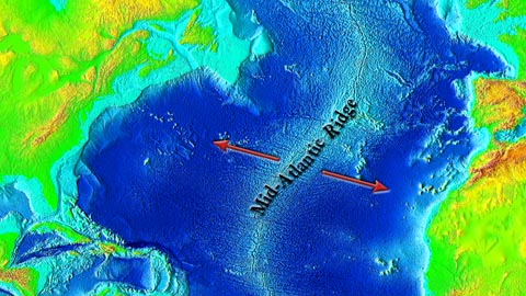
The image shows the Mid Atlantic Ridge. Which type of boundary occurs at this ridge where the ocean floor is spreading apart?
a)
convergent
b)
divergent
c)
transform fault
11.
Mountains form from ...
a)
plates sliding past one another
b)
collision of plates
c)
plates moving away from each other
12.
Associated with transform boundaries.
a)
Volcanoes
b)
mountains
c)
trenches
d)
earthquakes
13.
This land formation occurs at a divergent continental/ continental boundary.
a)
mid ocean ridge
b)
deep ocean trench
c)
pacific hot spot
d)
rift valley
14.
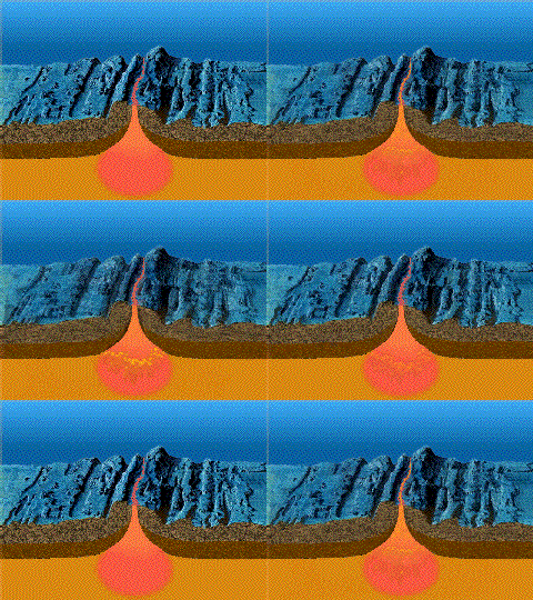
What type of boundary creates new seafloor?
a)
convergent ocean ocean
b)
convergent ocean continental
c)
convergent continental continental
d)
divergent
15.

Earthquakes and volcanoes are most likely found in which locations?
a)
at plate boundaries
b)
in oceans
c)
in the middle of continents
d)
in the middle of plates
16.
Which type of evidence was NOT used by Alfred Wegener to support his continental drift hypothesis?
a)
Similar mountain ranges found on the eastern side of South America and the western side of Africa.
b)
Identical fossils found on different continents.
c)
Erosion and Weather appears on Mountain Ranges across the world.
d)
Glacial erosion found in Australia India,and Africa.
17.
In the early 1900's Alfred Wegener found evidence of identical rock types, identical fossils, and matching mountain ranges on different continents that are on opposite sides of an ocean. What could be the explanation for these observations?
a)
All animals can swim extremely long distances
b)
These observations have no significant meaning.
c)
In the past, continents were not located where they are today but were joined together
d)
mountains are made through the same processes therefore they are very similar in their structure throughout the entire world.
18.
All of the statements below supported the Theory of Continental Drift, EXECPT
a)
Continents look like they fit together like puzzle pieces, especially South America and Africa.
b)
Antarctica's land forms shows evidence of glacial erosion.
c)
Fossils match on different continents
d)
Rock formations match on different continents
19.

Which letter shows runoff?
a)
A
b)
B
c)
C
20.

Which letter shows groundwater flow?
a)
A
b)
B
c)
C
21.
Water stored below the Earth's surface is called:
a)
Groundwater
b)
Bogs
c)
Water in the ground
22.

Because they have large connected pores, materials such as sand and gravel allow water to percolate, or pass through. This is known as
a)
Permeable
b)
Impermeable
23.

An underground layer of rock or sediment that holds water?
a)
Reservoir
b)
Aquifer
c)
Groundwater
d)
Watershed
24.

The land area that supplies water to a river system is called a
a)
water table
b)
trailer
c)
house
d)
watershed
25.
The use of pesticides and fertilizers must be carefully monitored because of the effect they can have on the environment.
Which of the following is a possible negative effect of the use of these chemicals on the environment?
Which of the following is a possible negative effect of the use of these chemicals on the environment?
a)
Runoff carries these chemicals into lakes and streams.
b)
Theses chemicals cannot be purchased in large bulk.
c)
These chemicals are expensive to produce.
d)
Storage space for these chemicals is limited.
100 %

