
 Worksheets
Forces That Change the Earth
Total questions: 43
Worksheet time: 34mins
Name
Class
Date
1.
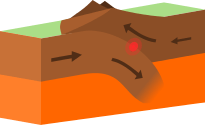
What type of plate boundary is this?
a)
Plate
b)
Divergent
c)
Convergent
d)
Transform
2.

What type of event can occur at this boundary?
a)
Earthquake
b)
Volcano Eruption
c)
Tornado
d)
Mountain Building
3.
Which of the following causes Earth's tectonic plates to move?
a)
Energy from the Sun
b)
Magnetic Pole Reversal
c)
Convection currents in the mantle
d)
Faults in Mountain Ranges
4.
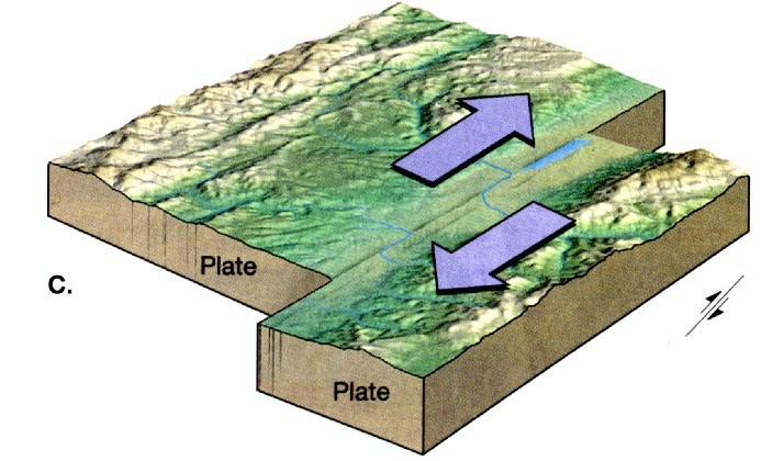
What type of plate boundary is this?
a)
Transform
b)
Convergent
c)
Divergent
d)
Plate
5.
The theory that says Earth's continents once made up an ancient supercontinent, and have been drifting apart ever since, led to the current theory of...
a)
Pangea
b)
Plate Tectonics
c)
Natural Selection
d)
Gravity
6.
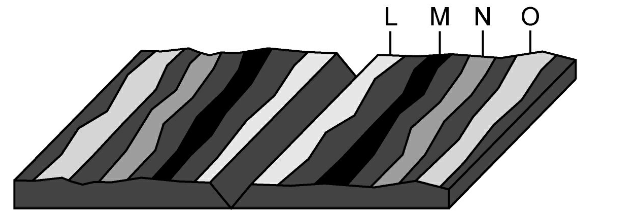
Where would the youngest rock be found?
a)
L
b)
M
c)
N
d)
O
7.
Mountains are created when....
a)
Two continental plates collide
b)
Two oceanic plates pull apart
c)
An Oceanic plate subducts under a Continental Plate
d)
Two continental plates pull apart
8.
When an oceanic plate and a continental plate collide, which one will subduct?
a)
oceanic
b)
continental
c)
neither
9.
A mid-ocean ridge occurs at a ________ plate boundary.
a)
transform
b)
convergent
c)
divergent
10.

Which of these events can ONLY happen on a DIVERGENT BOUNDARY?
a)
Rift Valley
b)
Mountain
c)
A delta
d)
An insanely complex, long answer that you will click out of instinct.
11.
When one plate slides underneath another (subducts), the sunken plate _________ and the magma within the asthenosphere heats up and _________.
a)
hardens, sinks
b)
melts, sinks
c)
hardens, rises
d)
melts, rises
12.
Subduction zones in the ocean can create which features?
a)
islands
b)
volcanoes
c)
trenches
d)
all of the above
13.

Who is the person credited with developing the theory of continental drift?
a)
Harry Hess
b)
Galileo
c)
Alfred Wegener
d)
Newton
14.
What are mid-ocean ridges?
a)
A chain of underwater waterfalls
b)
A chain of underwater volcanos
c)
A chain of underwater mountains
d)
A chain of underwater rocks
15.
What is Pangaea?
a)
The name of a German Scientist
b)
the name of the supercontinent that existed millions of years ago
c)
another name for continental drift
d)
the name of an ancient fossil
16.
The area around the Pacific Plate where volcanic activity is common is called the -
a)
Death Ring
b)
Fire Zone
c)
Ring of Fire
d)
Zone of Fire
17.
This land formation occurs at a divergent continental/continental boundary.
a)
mid ocean ridge
b)
deep ocean trench
c)
Pacific hot spot
d)
rift valley
18.
Which of the following did not support continental drift?
a)
magnetic striping on the ocean floor
b)
identical fossils on continents
c)
mountain ranges
d)
coastlines fit like a puzzle
19.

Scientists think that convection currents that move the plates flow in Earth's -
a)
continental crust
b)
oceanic crust
c)
asthenosphere
d)
lithosphere
20.

The physical layer of Earth made of solid rock and soil is called the ___________.
a)
mesosphere
b)
lithosphere
c)
asthenosphere
d)
mantle
21.
Which of the following occurs because of convection currents?
a)
Tectonic plates on the crust move.
b)
The mantle increases in size.
c)
Pressure in the crust increases.
d)
Pressure in the crust decreases.
22.

What is the elevation of point B?
a)
800 ft
b)
850 ft
c)
900 ft
d)
1000 ft
23.

In which direction is Mill River flowing?
a)
Southeast
b)
Southwest
c)
Northeast
d)
Northwest
24.

What is a possible elevation of Y?
a)
Between 121-139 meters
b)
Between 100-120 meters
c)
Between 141-159 meters
d)
Between 81-101 meters
25.

The distance from D to E is...
a)
A little over 2 km
b)
A little over 3 km
c)
A little over 4 km
d)
A little over 5 km
26.

What is the elevation of the peak of the small island on the left side?
a)
About 20 meters
b)
About 40 meters
c)
About 60 meters
d)
About 200 meters
27.

What is the elevation of A?
a)
10 meters
b)
20 meters
c)
40 meters
d)
120 meters
28.

What feature is formed at B?
a)
river
b)
rift valley
c)
sink hole
d)
mountain
29.

If we were in a plane, Path B --> C is about the same distance as path E --> N. If you had to WALK the paths, which path would be easier?
a)
B --> C is the easier walk
b)
E --> N is the easier walk
c)
B --> C and E --> N are the same walking distance
30.

What feature is at the arrow?
a)
volcano
b)
mountain
c)
cliff
d)
river
31.

Determine the contour interval:
a)
5 m
b)
10 m
c)
15 m
d)
20 m
32.

The steepest slope on this hill can be found on the side that is facing which direction?
a)
Southwest
b)
Northeast
c)
Northwest
d)
Southeast
33.

Which topographic map matches formation C?
a)
1
b)
2
c)
3
d)
4
34.

What is the profile view to Topographic Map #1?
a)
A
b)
B
c)
D
d)
F
35.

What is the profile view to Topographic Map #2?
a)
B
b)
C
c)
D
d)
E
36.
What is a Delta?
a)
A landform that occurs where a river or stream flows into the ocean
b)
A landform that occurs where a mountain is split in half
c)
A landform that occurs where the ocean flows into a river or stream
d)
A landform that occurs where volcanoes erupt
37.

What height must a hiker (X) climb to reach the peak of the mountain?
a)
303m
b)
253m
c)
300m
d)
200m
38.
Erosion occurs when...
a)
soil and rock are moved through the action of water and wind
b)
rock is broken down
c)
sediment is deposited
d)
volcanoes erupt
39.

Provided is a satellite image of a glacier as it moves down a mountain and into the bay.
What is the general direction of movement of the glacier?
What is the general direction of movement of the glacier?
a)
North
b)
South
c)
East
d)
West
40.

What would be the most likely way this coastline would change over time?
a)
A fire could destroy the vegetation
b)
The waves could erode the beach
c)
The beach would grow due to deposition
d)
The beach will disappear due to plate tectonics
41.

A satellite image of an area in Florida shows a river with slight bends along its length. A second satellite image taken of the same area 10 years later shows the same river with a different course. What is the best explanation for the difference in the shape of the river's course between the two satellite images?
a)
Wind blew waves across the water surface, eroding away the bank on one side of the river until the river's course changed its shape
b)
Regular freezing and thawing of the river split the soil along the river banks, changing the shape of the river
c)
Water eroded the banks of the river and deposited the eroded soil on opposite banks, causing the river to form tighter bends
d)
Acid rain chemically weathered the banks along the river, forcing the river to wind back and forth
42.

These images compare the same stretch of coastline. What is a possible reason for the change?
a)
A fire destroyed the beach and surrounding area
b)
Overtime, water eroded away much of the land
c)
A major catastrophe such as a hurricane or tsunami destroyed the area
d)
The beach and land went through a sever drought
43.

If new ocean floor is created at a divergent boundary, why does the circumference of the Earth not change?
a)
The Earth is actually getting larger
b)
There are boundaries where crust is subducted and recycled
c)
Transform boundaries are the opposite of divergent, so they counteract each other
d)
The Earth is actually getting smaller
100 %

