
 Worksheets
Unit 11 Review Activities 3: Tides and Moon Phases
Total questions: 76
Worksheet time: 3hrs 35mins


The path of Foucault's Pendulum provides evidence that Earth
has an elliptical orbit
is tilted on its axis
revolves in its orbit
rotates on its axis
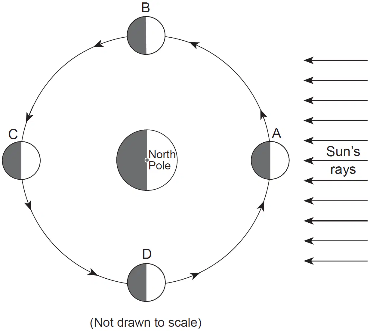
Which diagram best represents the moon phase located at position D?


Which diagram best represents the moon phase located at position A?
Which diagram best represents the moon phase located at position C?
Which moon phase would an observer view a solar eclipse on Earth?
New Moon
First Quarter
Third Quarter
Full Moon

Around which Date can you see Libra & Scorpius in the sky at midnight?
(a)

At a location in the Northern Hemisphere, a camera was placed outside at night with the lens pointing straight up. The shutter was left open for four hours, resulting in the star trails shown below.
How many degrees did each star travel?
1°N
30° N
60°N
90°N


Which motion allows an observer on Earth to view different constellations throughout the year?
Earth orbiting the Sun
constellations orbiting Earth
Earth orbiting the constellations
constellations orbiting the Sun

What table correctly matches each type of eclipse with the orbital position of the Moon and cause of each eclipse?


What is the time in Boston when it is 11 am in San Diego?
8 am
2 pm
3 pm
noon

The diagrams below represent the constellations seen by an observer in New York State while looking toward the southern horizon at midnight on July 9 and January 8.
Which motion is mainly responsible for the difference in the constellations visible at midnight on these two dates?
The Sun orbits Earth
Earth orbits the Sun
The stars in the constellations orbit Earth
Earth orbits the stars in the constellations

What is the location of point B?
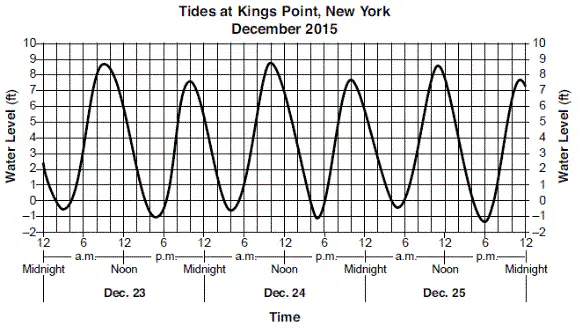
These Long Island tides show a pattern that is
cyclic and predictable
cyclic and unpredictable
noncyclic and predictable
noncyclic and unpredictable

4.The diagram below shows Earth's orbit around the Sun. Locations A, B, C, and D represent Earth on the first day of each season.
Which location represents March 21?
A
B
C
D

Base your answer to the following question on the graph below, which shows the maximum altitude of the Moon, measured by an observer located at a latitude of 43° N during June in a particular year. The names and appearance of the four major Moon phases are shown at the top of the graph, directly above the date on which the phase occurred.
Which diagram best represents the Moon’s phase observed on June 11?


Base your answer to the following question on the diagram below, which represents latitude and longitude lines on Earth. Points A through E represent locations on Earth. Arrows represent direction of rotation.
When the local time at location C is 3 p.m., the local time at location D is
1 p.m.
5 p.m.
3 p.m.
3 a.m.

Base your answer to the following question on the diagram below and on your knowledge of Earth science. The diagram represents Earth's position in its orbit on the first day of each of the four seasons, one of which is labeled A. The North Pole is labeled N. Earth's closest distance to the Sun and Earth's farthest distance from the Sun are labeled in kilometers.
When Earth is closest to the Sun, which season is occurring in the Northern Hemisphere?
A) spring B) summer C) fall D) winter
SPRING
SUMMER
FALL
WINTER
3. A student recorded the times of three successive high tides at one location as: 9:12 a.m.
9:38 p.m.
10:04 a.m.
What is the approximate time of the next high tide?
A) 10:12 p.m
B) 10:30 p.m.
C) 10:38 p.m.
D) 11:04 p.m.

Base your answer to the following question on the graph below, which shows two days of tidal data from a coastal location in the northeastern United States, If the pattern shown continues, the most likely height and time form = the first high tide on day 3 would be
A. 2.2 meters at 4 a.m.
2.2 meters at 5 a.m.
2.3 meters at 4 a.m.
2.3 meters at 5 a.m.

Base your answer to the following question on "the diagram below, which has lettered arrows showing the motions of Earth and the Moon.
These lettered arrows represent motions that are
A) noncyclic and unpredictable
B) noncyclic and predictable
C) cyclic and unpredictable
D) cyclic and predictable

one degree per day?
23.5° to 30°, summers in New York State would
become

both provide evidence of Earth’s:


The diagram above represents Earth and the Sun’s incoming rays. Letters A, B, C, and D represent locations on Earth’s surface. Which two locations are receiving the same intensity of insolation?
A and B
B and C
C and D
D and B
Why does the Moon and the Sun appear to have the same diameter?
They are both the same size
The Sun is closer so it looks smaller
The Moon is closer to Earth, so it appears bigger
The Moon and Sun are the same distance away from the Earth

At which point on the Earth's surface can a person see the sun overhead?
D
A
K
G

How many hours was the lens left open to produce the photograph?
12
2
6
4
During a time exposure of the photograph, the stars appear to have moved through an arc of 120°. How many hours did it take to make this star trail?
5 h
8 h
12 h
15 h
Why are some constellations visible to New York State observers at midnight during April, but not visible at midnight during October?
Earth rotates on its axis.
Earth revolves around the Sun.
Constellations have elliptical orbits.
Constellations move within our galaxy.


38. What causes the water-level variation pattern shown by the graph?
changes in wind velocity produced by coastal storms
changes in magnetic orientation of the North American Plate
Earth's revolution and the distance from the equator
Earth's rotation and the gravitational pull of the Moon

37. These changing water levels at Montauk can best be described as
cyclic and predictable
cyclic and not predictable
noncyclic and not predictable
noncyclic and predictable

36. The graph shows the observed water levels, in feet (ft), for a tide gauge located at Montauk, New York, on the easternmost end of Long Island, from January 24, 2008 to noon on January 25, 2008. What was the height of the water above average low tide level at noon on January 24?
1.2 ft
1.6 ft
2.2 ft
2.6 ft

39. The graph shows the observed water levels, in feet (ft), for a tide gauge located at Montauk, New York, on the easternmost end of Long Island, from January 24, 2008 to noon on January 25, 2008. What is the approximate latitude and longitude of the tide gauge?
40°30' N 72°00' W
40°30' N 74°00' W
41°00' N 72°00' W
41°00' N 74°00' W

