
 Worksheets
Intro to Geography
Total questions: 122
Worksheet time: 1hrs 4mins
Name
Class
Date
1.
Geography is the study of ___.
a)
space
b)
earth
c)
robots
d)
electricity and currents
2.
physical geography is relating to...
a)
people
b)
nature
3.
There are two types of geography... human and physical.
a)
true
b)
false
4.
Human geography is...
a)
relating to people
b)
relating to natrure
5.
Dams, roads, bridges, skyscrapers, and other man-made features would be considered which type of geography?
a)
physical
b)
human
c)
environmental
d)
economic
6.
Mountains, forests, wet, humid, flat, lakes, etc. are examples of which type of geography?
a)
human
b)
phsycial
c)
economic
d)
environmental
7.
Map makers are called...
a)
cartographers
b)
meteorologists
c)
teachers
d)
applied geographers
8.
What is the imaginary line the divides the earth into the Northern Hemisphere and the Southern Hemisphere?
a)
tropic of cancer
b)
tropic of capricorn
c)
equator
d)
prime meridian
9.
The four oceans of the world are ...
a)
Indian, Atlantic, Arctic, Pacific
b)
Atlantic, Pacific, Arctic, Antarctic
c)
Atlantic, Arctic, Indian, Antarctic
d)
Pacific, Indian, Arctic, Antarctic
10.
Which of the following is NOT one of the 7 continents.
a)
Europe
b)
Asia
c)
Africa
d)
China
11.
Which of the following is NOT one of the 7 continents.
a)
North America
b)
United States
c)
Australia
d)
South America
12.
The climate of a region close to the north pole is warmer than a climate close to the equator.
a)
true
b)
false
13.
Trees, flowers, and grass are all examples of what type of natural resource?
a)
Vegetation
b)
Raw materials
c)
Fossil Fuels
d)
Non-renewable resources
14.
The ocean closest to California is....
a)
Indian Ocean
b)
Atlantic Ocean
c)
Pacific Ocean
d)
Southern Ocean
15.
We live on the continent of....
a)
South America
b)
North America
c)
Europe
d)
Antarctica
16.
There are ____ continents on Earth.
a)
5
b)
12
c)
7
17.
True or False: Continents are large landmasses.
a)
True
b)
False
18.
Geography is....
a)
the study of people
b)
the study of the Earth
c)
the study of continents
19.
Longitude measures north and south of the equator.
a)
True
b)
False
20.
What shows the cardinal directions on a map?
a)
Map Key
b)
Compass Rose
c)
Scale
d)
Map Title
21.
How do you know distance on a map?
a)
Map Key
b)
Compass Rose
c)
Cardinal Directions
d)
Scale
22.
Who makes maps?
a)
Cartographers
b)
Geographers
c)
Philosophers
23.
What is latitude?
a)
Solid lines surrounding the earth
b)
Distance east or west of the Prime Meridian, measured in degrees. Lines run north and south.
c)
Distance north or south of the Equator, measured in kilometers. Lines run east and west.
d)
Distance north or south of the Equator, measured in degrees. Lines run east and west.
24.
What is the Prime Meridian?
a)
0 degrees latitude and goes through Greenwich, England
b)
0 degrees longitude and goes through Greenwich, England.
c)
0 degrees longitude and goes through Lansing, Michigan
d)
0 degrees latitude and goes through Detroit, Michigan
25.
What is the equator?
a)
Imaginary line of latitude that separates the earth into 2 equal hemisperes
b)
Imaginary line of longitude that separates the earth into 2 equal hemispheres
26.
What is a hemisphere?
a)
One-third of the earth
b)
The top of the earth
c)
One-half of the earth
d)
The bottom of the earth
27.
What is longitude?
a)
Distance east or west of the Prime Meridian. Lines run north and south.
b)
Distance east or west of the equator. Lines run north and south.
c)
Distance north or south of the Prime Meridian. Lines run east and west.
d)
Solid lines around the earth
28.
What are degrees?
a)
Units used to measure time
b)
Units used to measure depth
c)
Units used to measure elevation
d)
Units used to measure latitude and longitude
29.
What is a compass rose?
a)
A political map
b)
A figure on a map or globe to reference direction
c)
A beautiful flower on a map
d)
A symbol on a map that shows distance
30.
Election results would be found on what kind of map?
a)
Topographical map
b)
Special-purpose map
c)
Physical map
d)
Thematic map
31.
Topographical maps show what?
a)
elevation
b)
roads
c)
borders
d)
graphs
32.
Location is...
a)
where places are
b)
connections among things
c)
an area with similar characteristics
d)
relationship between people & the environment
33.
What is a Region?
a)
the interaction between people and environment
b)
movement of people and goods
c)
an area that shares a common feature
d)
an area that is diverse
34.
What is distorted on an equal-area projection map?
a)
edges of the map
b)
distances and sizes
c)
nothing
d)
landmasses
35.
Natural features are shown on what type of map?
a)
Topological map
b)
Political map
c)
Physical map
d)
Thematic map
36.
What can you find on a Political Map?
a)
election results
b)
elevations
c)
temperature ranges
d)
state capitals
37.
What does location describe?
a)
Where a place is found
b)
a place
c)
a type of map
d)
a cartographer
38.
What do lines of latitude and longitude show?
a)
Exact locations on the earth's surface
b)
Mountain range elevations
c)
Oceans and landforms
d)
Earth's rotation around the sun
39.
Geographers want to know...
a)
where things are located
b)
where Earth is in the Solar System
c)
the shape of the earth
d)
what time it is
40.
What do north-south lines measure?
a)
latitude
b)
cardinal directions
c)
longitude
d)
place
41.
What is an example of an intermediate direction?
a)
northeast
b)
south
c)
northsouth
d)
west
42.
Jiffy Mix uses trucks to transport their products to grocery stores. This is an example of what theme?
a)
Place
b)
Human-environment interaction
c)
Driving
d)
Movement
43.
Wearing a warm coat in the winter is an example of what?
a)
Fashion
b)
Movement
c)
Region
d)
Human-environment interaction
44.
Heating and cooling Beach Middle School is an example of what?
a)
Comfort
b)
Human-environment interaction
c)
Movement
d)
Place
45.
What is geography?
a)
The study of human features on Earth
b)
The study of human and non-human features on Earth
c)
The study of non-human features on Earth
d)
The study of human and non-human features on Mars
46.
A box on a map that explains the markings on the map
a)
Parallels
b)
Compass Rose
c)
Scale
d)
Legend
47.
An imaginary North/South line that cuts the earth in 1/2
a)
Equator
b)
Prime Meridian
c)
Latitude
d)
North Pole
48.
An imaginary East/West line that cuts the earth in 1/2
a)
Longitude
b)
Prime Meridian
c)
Equator
d)
Parallels
49.
The northernmost point on earth
a)
Prime Meridian
b)
Antarctica
c)
Compass Rose
d)
North Pole
50.
Lines that run East and West around the globe
a)
Latitude
b)
Longitude
c)
Equator
d)
Prime Meridian
51.
Lines that run North and South around the globe
a)
Latitude
b)
Longitude
c)
Prime Meridian
d)
Equator
52.

Africa
a)
1
b)
2
c)
6
d)
7
53.

Pacific Ocean
a)
A
b)
B
c)
C
d)
D
54.

Atlantic Ocean
a)
A
b)
C
c)
D
d)
E
55.

Indian Ocean
a)
A
b)
B
c)
C
d)
D
56.

Arctic Ocean
a)
A
b)
B
c)
C
d)
D
57.

Which continent ONLY lies in the northern and western atmospheres?
a)
Europe
b)
North America
c)
Asia
d)
Antarctica
58.

Which continent only lies in the southern, western and eastern atmospheres?
a)
South America
b)
Australia
c)
Africa
d)
Antarctica
59.

Which continent lies only in the northern, eastern and western atmospheres?
a)
Europe
b)
Asia
c)
North America
d)
Africa
60.

Which continent lies only in southern and eastern atmospheres?
a)
Antarctica
b)
Asia
c)
Australia
d)
South America
61.

Which continent is south and west of Africa
a)
North America
b)
South America
c)
Australia
d)
Europe
62.

Which city is located at 33 degrees north and 84 degrees west.
a)
Memphis
b)
Atlanta
c)
Dallas
d)
Cincinnati
63.

What are the coordinates of Reno, Nevada?
a)
39 degrees north, 119 degrees west
b)
39 degrees north, 29 degrees west
c)
41 degrees north, 119 degrees west
d)
119 degrees north, 39 degrees west
64.
The Southern-most point on the globe
a)
North Pole
b)
South Pole
c)
Prime Meridian
d)
Antarctica
65.
This feature is used to show
one or more locations/ geographical regions.
a)
Glossary
b)
Maps
c)
Captions
d)
None of the above
66.

This continent contains major historic cities like Paris, London and Rome.
a)
Africa
b)
Europe
c)
Asia
d)
North America
67.

This is the smallest continent, farthest away from the others where you may find koalas and kangaroos.
a)
Europe
b)
Africa
c)
South America
d)
Australia
68.
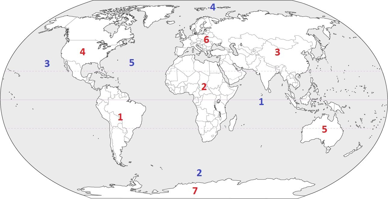
Identify the ocean at location #5
a)
Atlantic Ocean
b)
Southern Ocean
c)
Pacific Ocean
d)
Arctic Ocean
69.
How many continents are there in the world?
a)
4
b)
5
c)
6
d)
7
70.
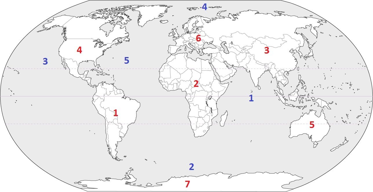
Which continent is located at #3?
a)
Australia
b)
Asia
c)
Europe
d)
South America
71.
The 0 degree mark of longitude is known as the ___________ ______________ measure from Greenwich England.
a)
Equator
b)
Prime Meridian
c)
International Date Line
d)
Contour Line
72.

What is the reason why latitude lines NEVER intersect?
a)
They converge at the poles
b)
They are cool
c)
They are vertical lines
d)
They are parallel
73.
What is half of a sphere called?
a)
Halfsphere
b)
Semisphere
c)
Hemisphere
d)
Half circle
74.
Maps should contain the following five things: 1) a title, 2) borders, 3) a compass rose, 4) ________, and 5) ________ .
a)
continents and countries
b)
landforms and water
c)
map key and symbols
d)
roads and golf courses
75.

What comes to the right of the N (north) on this compass rose?
a)
S (south)
b)
E (east)
c)
W (west)
d)
N (north)
76.
Why would an airline pilot or ship's captain use latitude and longitude lines?
a)
To fly or sail in a straight line
b)
To check the weather
c)
So they know where in the world they are located
d)
To hand up their laundry
77.
Lines of latitude and longitude are measured in-
a)
only north and south
b)
degrees of a circle
c)
only east and west
d)
degrees of a compass
78.
Latitude lines on a globe measure from-
a)
north to south
b)
east to west
c)
north to east
d)
south to west
79.
_______ lines on a globe run from east to west.
a)
North Pole
b)
South Pole
c)
Latitude
d)
Longitude
80.
Imaginary lines that run from the north pole to the south pole
a)
latitude
b)
time zones
c)
longitude
d)
parallel
81.

This map is an example of what type of region?
a)
Formal
b)
Functional
c)
Perceptual
d)
National
82.

The Middle East is considered what type of region?
a)
Formal
b)
Functional
c)
Perceptual
d)
Regional
83.
The primary purpose of a _____________ map is to show landforms and terrain.
a)
Political
b)
Thematic
c)
Physical
d)
Population
84.

This is an example of human interaction environment:
a)
adapt
b)
alter
85.
20811 Ella Boulevard, Spring, Texas 77388 is an example of
a)
absolute location
b)
relative location
c)
Klein Collins High School
d)
Place
86.

This is an example of a
a)
Physical Map
b)
Political Map
87.

This is an example of a
a)
Physical Map
b)
Political Map
88.
When reading a map, the first thing you should look at is the
a)
Key
b)
Scale
c)
Title
d)
Compass Rose
89.
The primary purpose of a __________ map is to show government boundaries of countries and states.
a)
Political
b)
Physical
c)
Thematic
d)
Topographic
90.
T/F: Movement refers to the way people, products, information, and ideas move from one place to another.
a)
True
b)
False
91.
T/F: Geographers study maps to study places and the relationships between people and their environment.
a)
True
b)
False
92.
What type of map could help you locate raw materials like timber that could be used in building a settlement during the Zombie Apocalypse?
a)
Physical Map
b)
Resource Map
c)
Economic Map
d)
Topographical Map
93.
Which of the Five Themes of Geography identifies the character of any given spot on the globe?
a)
Location
b)
Movement
c)
Place
d)
Region
94.
Which of the following is NOT an example of a physical characteristic of a place?
a)
Mountains
b)
Population
c)
Waterways
d)
Forests
95.
Which of the following is NOT an example of a human characteristic of a place?
a)
Religion
b)
Population
c)
Language
d)
Elevation
96.
Gardner Edgerton High School is located just North of Highway 56 on the West side of Gardner. This is an example of what type of location?
a)
Absolute
b)
Informal
c)
Relative
d)
Formal
97.
Gardner Edgerton High School is located at 425 Waverly Road in Gardner, KS 66030. This is an example of what type of location?
a)
Absolute
b)
Informal
c)
Relative
d)
Formal
98.
What part(s) of a map will help you figure out what an object or place is (i.e. mountains, city, etc.) on the map?
a)
Compass Rose
b)
Scale
c)
Symbol and Legend
d)
Grid and Index
99.
What part(s) of a map will help you figure out the distance between two places in the real world?
a)
Compass Rose
b)
Scale
c)
Symbol and Legend
d)
Grid and Index
100.
What type of map would be most helpful in navigating terrain by foot as you search for survivors and safety during the Zombie Apocalypse?
a)
Topographical Map
b)
Political Map
c)
Physical Map
d)
Climate Map
101.
What type of map could help you identify major cities to avoid as likely hotspots for Zombies?
a)
Topographical Map
b)
Political Map
c)
Physical Map
d)
Economic Map
102.
What type of map could help you identify major thoroughfares where Zombies are most likely to travel?
a)
Topographical Map
b)
Political Map
c)
Road Map
d)
Economic Map
103.
What type of map could help you locate lush valleys surrounded by mountains that could serve as a potential settlement in the Zombie Apocalypse?
a)
Physical Map
b)
Political Map
c)
Road Map
d)
Resource Map
104.
What is a flat representation of the earth's surface?
a)
Atlas
b)
Globe
c)
Map
d)
Infographic
105.
What is the geographic Theme that refers to several areas that share at least one human and/or physical characteristic?
a)
Location
b)
Place
c)
Region
d)
Movement
106.
What is the geographic Theme that refers to the translocation of people, goods, and ideas between two or more places?
a)
Human-Environment Interaction
b)
Place
c)
Region
d)
Movement
107.
What is the geographic Theme that refers to the dependence, adaptation, and modification of the earth by people?
a)
Human-Environment Interaction
b)
Place
c)
Region
d)
Movement
108.

If you were in Savannah, GA, on what coast of the U.S. would you be located?
a)
East Coast
b)
West Coast
c)
South Coast
d)
No Coast
109.

North Pole is the northernmost point in the world.
a)
True
b)
False
110.

On which continent is Lebanon located?
a)
Africa
b)
Asia
c)
Europe
111.

The large country that borders France to the south is Spain?
a)
True
b)
False
112.

In which continent would you find the country of Sweden?
a)
Europe
b)
Asia
c)
Africa
113.

In which continent would you find the country of Vatican City?
a)
Africa
b)
Asia
c)
Europe
114.
Which of these countries is NOT in Africa?
a)
Morocco
b)
Cameroon
c)
Thailand
115.
Which climate best characterizes the high latitudes?
a)
Tropical
b)
Subarctic
c)
Humid continental
d)
Marine West Coast
116.

This symbol identifies which feature of a map?
a)
Orientation
b)
Contour
c)
Distance
d)
Projection
117.

a)
Tornado
b)
Hurricane
c)
Blizzard
d)
Mistral
118.
Mexico is linked more to Central and South America than to North America because of the way geographers define -
a)
political regions
b)
physical regions
c)
economic regions
d)
cultural regions
119.

a)
North America
b)
Australia
c)
Europe
d)
South America
120.

This map supports the conclusion that malnutrition is most likely to occur in which country?
a)
Peru
b)
Brazil
c)
Bolivia
d)
Argentina
121.
"2/3 of Israel is desert. However, fruits and vegetables grown in Israel are sold around the world. The Israelis invented an underground irrigation system that takes water straight to the roots of the plants." This information is an example of how technology -
a)
influences agricultural production
b)
alters climate conditions
c)
increases energy usage
d)
affects transportation patterns
122.
A construction company would seek the assistance of geographers in order to -
a)
find adequate construction materials
b)
locate suitable construction sites
c)
develop advanced construction methods
d)
identify qualified construction workers
100 %

