
 Worksheets
AP Human Geography Review #3
Total questions: 119
Worksheet time: 1hrs 4mins
Absolute Location
describing how far a distance is quantitative units of distance (miles, kilometers, etc.)
describing the distance between locations using qualitative terms or non-traditional measurements of distance (one hour north of Walmart)
describing where something is using the exact site on an objective coordinate system (Long. & Lat.)
describing the position of a place as compared to (or relative to!) another landmark (near the beach)
Relative Location
describing the distance between locations using qualitative terms or non-traditional measurements of distance (one hour north of Walmart)
describing how far a distance is quantitative units of distance (miles, kilometers, etc.)
describing where something is using the exact site on an objective coordinate system (Long. & Lat.)
describing the position of a place as compared to (or relative to!) another landmark (near the beach)
Thematic Map
maps that emphasizes the location of places (without data attached)
a map that displays not only locations but maps a topic or theme of information with the location
The arrangement of the natural and artificial physical features of an area.
the belief that a physical environment is THE reason that some societies are strong while others are weaker
Environmental Determinism
the flow of goods, people, or information among places, in response to localized supply and demand
a region based around a node or focal point - terrestrial radio broadcasts are an example of this
useful for gathering SOME types of information. It can show you things like physical features, locations of urban areas, refugee camps, traffic, military targets, agriculture, etc.
the belief that a physical environment is THE reason that some societies are strong while others are weaker
Reference Map
the belief that a physical environment is THE reason that some societies are strong while others are weaker
a map that displays not only locations but maps a topic or theme of information with the location
The arrangement of the natural and artificial physical features of an area.
maps that emphasizes the location of places (without data attached)
Map Projections
detailed observations that provide insight into a group of people in a specific area
arrangement of a phenomenon across the Earth's surface (clustering/dispersal)
a method of taking a 3D object and putting in on a 2D plane
objective data that is fact based, usually measurable and usually expressed in numbers
GIS
relating to data that is specific to one location
software that captures, manages, analyzes, and displays data that is collected geographically
a system that measures distance from a series of satellites to determine location on the planet
the science of making measurements of the earth using sensors on airplanes or satellites
Natural Resources
a metaphor that explains that effort must be used to overcome distance
a physical material constituting part of Earth that people need and value
the idea that the world feels smaller than it used to because of increased technology in transportation and communication
the idea that the interaction between two places declines as the distance between them increases

What kind of map is this?
Robinson
Mercator
Goode Homolasine
Van Peters
Azimuthal

What map is this?
Mercator
Robinson
Peters Equal Area
Goode Homolasine
Azimuthal

Is this map large or small scale?
Large scale
small scale

Is this map large scale or small scale?
Large scale
Small scale
What is the name of this class?
AP World Geography
AP Human Geography
AP Environmental Science
World Geography
Name ONE vocabulary word from Unit 1

Identify the map above and identify which of the following descriptions most accurately describes the map.
Mercator: The shape and size of land masses are distorted, but direction is accurate
Robinson: Distortion is only happening with the size of the land masses, shape and direction are accurate
Mercator: Land mass size is accurate due to distortion being spread across all aspects of the map
Goode Homolosine: Does not use cardinal directions, minimizes distortion but is confusing to read
Robinson: Distortion is evenly spread out across shape, size, and direction making it less noticeable
Which of the following would geographers not be interested in observing when looking at a local place?
The physical terrain
The religious breakdown of citizens
The different languages that are spoken
The demographic breakdown of the entire country
The amount of rivers and lakes in the area
You being able to watch and learn on YouTube is an example of what spatial concept?
Distance decay
Tobler’s first law of geography
Time-space compression
Scale of inquiry
Clustering of information
Humans possess the ability to dominate their environment is known as
environmental determinism
possibilism
cartography
animism
demographics
Africa is a country
True
False
Which of these is NOT a continent?
Asia
Europe
Africa
The United States
Who was the geographer that had the theory we would run out of food, due to overpopulation?
Thomas Malthus
Karl Marx
Ester Boserup
Ravenstein
Who created the theory of Human Migration?
Thomas Malthus
Karl Marx
Ester Boserup
Ravenstein
Who went against Thomas Malthus's theory?
Thomas Malthus
Karl Marx
Ester Boserup
Ravenstein
What happens during stage one of The Epidemiologic Transition?
Pestilence and Famine- Black Plague
Receding Pandemic- Cholera
Degenerate Diseases- Cardiovascular Diseases
Delayed Degenerate Diseases- Cancer, Cardiovascular Diseases
What happens during stage two of The Epidemiologic Transition?
Pestilence and Famine- Black Plague
Receding Pandemic- Cholera
Degenerate Diseases- Cardiovascular Diseases
Delayed Degenerate Diseases- Cancer, Cardiovascular Diseases
What happens during stage three of The Epidemiologic Transition?
Pestilence and Famine- Black Plague
Receding Pandemic- Cholera
Degenerate Diseases- Cardiovascular Diseases
Delayed Degenerate Diseases- Cancer, Cardiovascular Diseases
What happens during stage four of The Epidemiologic Transition?
Pestilence and Famine- Black Plague
Receding Pandemic- Cholera
Degenerate Diseases- Cardiovascular Diseases
Delayed Degenerate Diseases- Cancer, Cardiovascular Diseases
What happens during stage one of the DTM?
Very High CBR, Very High CDR, Low NIR. ETM- Plauge, Mirgration Pattern- People moved seasonally in search of food.
*Agricultal Revolution
High CDR, Rapidly Decreasing CDR, High NIR. ETM- Overcrowded diseases, Cholera, Tuberculosis. Migration Pattern- International migration, people migrate from developing countries to developed countries.
*Medical Rev. and Industrial Rev.
Rapidly Declining CBR, Moderately Declining CDR, Moderate NIR. ETM- Degenerate Dieases, Cardiovascular, Migration Pattern- People migrate from rural areas to urban areas.
Very Low CBR, Low or Slightly increasing CDR, Zero or negative NIR. ETM- Delay Degerate dieases, Obesitiy, Alzhemiers, Mirgration Pattern- People move from cities to suburbs. *USA
What happens during stage two of the DTM?
Very High CBR, Very High CDR, Low NIR. ETM- Plauge, Mirgration Pattern- People moved seasonally in search of food.
*Agricultal Revolution
High CDR, Rapidly Decreasing CDR, High NIR. ETM- Overcrowded diseases, Cholera, Tuberculosis. Migration Pattern- International migration, people migrate from developing countries to developed countries.
*Medical Rev. and Industrial Rev.
Rapidly Declining CBR, Moderately Declining CDR, Moderate NIR. ETM- Degenerate Dieases, Cardiovascular, Migration Pattern- People migrate from rural areas to urban areas.
Very Low CBR, Low or Slightly increasing CDR, Zero or negative NIR. ETM- Delay Degerate dieases, Obesitiy, Alzhemiers, Mirgration Pattern- People move from cities to suburbs. *USA
What happens during stage three of the DTM?
Very High CBR, Very High CDR, Low NIR. ETM- Plauge, Mirgration Pattern- People moved seasonally in search of food.
*Agricultal Revolution
High CDR, Rapidly Decreasing CDR, High NIR. ETM- Overcrowded diseases, Cholera, Tuberculosis. Migration Pattern- International migration, people migrate from developing countries to developed countries.
*Medical Rev. and Industrial Rev.
Rapidly Declining CBR, Moderately Declining CDR, Moderate NIR. ETM- Degenerate Dieases, Cardiovascular, Migration Pattern- People migrate from rural areas to urban areas.
Very Low CBR, Low or Slightly increasing CDR, Zero or negative NIR. ETM- Delay Degerate dieases, Obesitiy, Alzhemiers, Mirgration Pattern- People move from cities to suburbs. *USA
What happens during stage four of the DTM?
Very High CBR, Very High CDR, Low NIR. ETM- Plauge, Mirgration Pattern- People moved seasonally in search of food.
*Agricultal Revolution
High CDR, Rapidly Decreasing CDR, High NIR. ETM- Overcrowded diseases, Cholera, Tuberculosis. Migration Pattern- International migration, people migrate from developing countries to developed countries.
*Medical Rev. and Industrial Rev.
Rapidly Declining CBR, Moderately Declining CDR, Moderate NIR. ETM- Degenerate Dieases, Cardiovascular, Migration Pattern- People migrate from rural areas to urban areas.
Very Low CBR, Low or Slightly increasing CDR, Zero or negative NIR. ETM- Delay Degerate dieases, Obesitiy, Alzhemiers, Mirgration Pattern- People move from cities to suburbs. *USA
Where are the least populated areas?
Dry Lands
Wet Lands
Cold Lands
High Lands
Hot Lands
Where do you find densely populated places?
South Asia
Southeast Asia
East Asia
Europe
Africa
What is stage one of the migration transition?
People move seasonally in search of food.
People move from developing countries to developed countries.
People move from rural areas to cities.
People move from Cities to Suburbs.
In which of the following countries is one most likely to find speakers whose native language belongs to the Uralic language family?
Libya
Cambodia
Kazakhstan
Portugal
Germany
Which of the following terms best describes the geographical boundary of one particular linguistic feature?
Language Border
Toponym
Choropleth interval
Linguistic hearth
Isogloss
Which of the following sacred places is most closely associated with animism?
Hagia Sophia
Ayers Rock
Sistine Chapel
Mecca
The Western Wall
Historically, culture diffusion patterns in the United States have tended to flow in which general direction?
East to West
West to East
North to South
South to North
Northwest to Southeast
A Hindu temple located in Texas is most likely the result of which kind of diffusion?
Expansion
Hierarchical
Contagious
Relocation
Stimulus
The religious doctrine of ahimsa, which discourages violence against other living beings, is best associated with which of the following regions?
North Africa
Western Europe
Arabian Peninsula
Andes Mountains
Indian Subcontinent
The persistence of ethnic urban enclaves in major American cities could be cited as evidence to support all of the following phenomena EXCEPT...
Chain migration
Residential segregation
Structural assimilation
multiculturalism
multinucleated urban structure
Which of the following folk architecture styles is ideally suited for a diurnil climate?
New York Dutch house
Iroquois longhouse
Garrison house
Adobe house
Log cabin
Compared to popular cultures, folk cultures are...
More cosmopolitan
More homogeneous
More diffuse
More transitory
More contagious Culture
A dialect is best classified as which of the following?
Cultural complex
Cultural trait
Language branch
Language group
Language family
A Mormon church located in a rural area of northwestern Colorado is most likely the result of which kind of diffusion?
Expansion
Relocation
Hierarchical
Maladaptive
Stimulus
Which of the following provides the clearest example of derelict landscape?
A gentrified, urban landscape
A rural, cultivated landscape
A suburban, residential landscape
An abandoned, industrial landscape
A preserved, sacred landscape
A vernacular house style, common throughout the American South during the 19th century, that featured a covered breezeway situated between two enclosed cabins is known as a...
Shotgun house
Norman cottage
Plantation house
Adobe house
Dogtrot house
Individuals' cognitive abilities to orient themselves in and navigate through familiar spaces are often aided by points of reference and points of intersection, which are respectively known as...
landmarks and edges
nodes and paths
landmarks and nodes
districts and nodes
edges and districts
A new fashion trend originated in New York City that diffuse to Los Angeles, Paris, and Tokyo before reaching rural areas of New York state would be an example of which of the following kinds of diffusion?
Contagious
Hierarchical
Uniform
Relocation
Stimulus
The Sunbelt and New England are two examples of which kind of culture region?
Functional
Formal
Vernacular
Municipal
Transnational
An immigrant who selectively adopts certain customs of the dominant host society in order to advance socioeconomically, while still retaining much of his or her native customs, practices, and beliefs, best illustrates the concept of...
Acculturation
Maladaptive behavior
Assimilation
Ethnocentrism
All of the above
A highly simplified language developed between linguistically heterogeneous groups for the purpose of basic inter-group communication is known as which of the following?
Creole
Pidgin
Lingua-franca
Bilingualism
Standard dialect
All of the following belong to the Indo-European language family EXCEPT...
Hindi
Bengali
Farsi
Mandarin
Dutch
A minaret is an architectural feature common to places of worship in which of the following regions?
Buddhism
Hinduism
Christianity
Judaism
Islam
A state is a synonym for a
territory
country
unit
member
The attempt by one country to force its political control over another territory is
constitutionality.
colonialism
self-determination
sovereignty.
The United Nations created these to help reduce disparities between developed and developing countries
Sustainability growth ideas
Subsistence Agriculture
Sustainable Development Goals
Sucky Ideas that don't fix much
Which Revolution marks the shift in working with hands to machines for mass production (and profit)?
Neolithic
Industrial
Green
Beatles
Trade Deficit
policy that promotes elimination of trade barriers, such as tariffs and quotas
when imports exceed exports
non-economic negative effects from trade
when exports exceed imports
A primate city such as Mexico City is
always located in the center of its country for maximum accessibility
more than twice the size of any other city in its country and dominant economically and culturally
most likely to share its rank size with at least one other city in the country
always a national capital serving as the seat of government and industrial center of the country
much larger than the cities in any neighboring country and serves as the region’s financial capital
According to Christaller’s central place model, which of the following would most likely have the smallest range?
A university
An international airport
A professional football stadium
A symphony orchestra hall
A grocery store
Central place theory describes the
spatial patterns of urban and outlying areas based on the flow of goods and services
tendency of different ethnic groups to congregate in a single location
tendency of civilizations to form around certain natural features
outward radiation of cultural patterns from a central place
tendency of wealth to concentrate in urban core areas
Megacities have a population of ...?
Over 1 million
Over 10 million
Over 20 million
Over 50 million
Where are the majority of megacities located?
Africa
Europe
Asia
The Americas
Which of the following was NOT a reason for rapid suburbanization in the United States after the Second World War?
Mass production of the automobile
Expansion of home construction
Expansion of the interstate highway system
Availability of low down payment terms and long-term mortgages
Reduction in long-distance commuting
Today, most of the United States and Canadian population lives in which of the following?
Farming areas
Metropolitan areas
Rural nonfarming areas
Central cities
Small towns
The multiple-nuclei model of city structure tends to be most applicable to
small cities
traditional cities
Latin American cities
newer, fast-growing cities
cities with homogeneous land use
Prior to 1850 the location of all major North American cities was related, chiefly, to the presence of
navigable waterways
transcontinental highways
defensive sites
railroad junctions
water power
In the new global economy, an increasing proportion of influential financial decisions are being made in
major corporate centers such as New York, London, and Tokyo
the informal sector
regional centers and small towns where fax machines are used
the field, close to the sources of agricultural production
national capitals because of the increasing importance of the nation state
Most Latin American cities are focused on a
government housing project
zone of heavy industry
central plaza
skyscraper office building
squatter settlement
According to the rank-size rule, if the largest city in a country has a population of 10 million, the next largest city will have a population of
9 million
8 million
7.5 million
5 million
3.5 million
In which zone of the city are land prices the highest?
CBD
Low Class Housing (Inner City)
Middle Class Housing (Suburbs)
High Class Housing (Rural-Urban Fringe)


Which of the following is an example of a smart growth policy for urban development?
Increasing the capacity of roads/highways
Decreasing the number or size of parks/greenspace
Increasing mixed-use land policies to combat sprawl
No longer permitting industrial zoning within city limits

Starting in the 1990's, a movement known as _________ began to feature mixed-use neighborhoods with businesses and residential properties, walkable areas and a variety of price ranges for homes.
blockbusting
gentrification
leapfrogging
new urbanism

Blockbusting and redlining have contributed to... in American cities.
gated communities
racial segregation
public transportation
exurbanization

Real estate agents have encouraged (often) white families to sell their houses at a loss once a (often) black or latino family moves into the neighborhood in a process known as...
redlining
gentrification
filtering
blockbusting

The images show examples of agricultural technology developed during different time periods. Which of the following statements is best supported by the images?
Image 2 shows an innovation that occurred in the Second Agricultural Revolution, reducing the amount of labor needed and increasing crop yields.
Image 2 shows an innovation that occurred late in the First Agricultural Revolution, increasing farmers' profits.
Image 1 shows an innovation that occurred early in the Second Agricultural Revolution resulting in more sustainable livestock production.
Image 2 shows an innovation that occurred in the Third Agricultural Revolution, resulting in a diffusion of agricultural practices to less developed countries.
Image 1 shows an innovation that occurred early in the Third Agricultural Revolution, improving the standard of living for small farmer families.
Which of the following best explains the significance of similarities between the farming practices for apple orchards and grape vineyards?
Both farming practices occur in the same climate region, which is found in places such as Italy and South Africa.
Both farming practices require considerable labor input because the fruit is picked by hand, making it a product of intensive agriculture.
Both farming practices are used for tropical plantation crops grown on large estates with hired labor who plant and harvest crops.
According to von Thünen, both farming practices occur in the outermost areas of agricultural land.
According to land-rent theory, both farming practices are found on small farms and must be located close to markets.

Using the data shown, which of the following best explains the spatial variations of rural women’s roles in food production and food preparation?
In less developed countries, females tend to participate more than males in harvesting and less in preparation tasks.
In more developed countries, females and males tend to participate equally in food-production tasks.
In less developed countries, females and males tend to participate equally in food-production tasks.
In more developed countries, females tend to participate more than males in harvesting and less in preparation tasks.
In less developed countries, females and males tend to participate equally in harvesting and preparation tasks.
Sheep production in New Zealand and poultry production in Arkansas produce food animals for human consumption. Which of the following best describes the differences in the agricultural practices and land use for these products?
Sheep production is an example of intensive agriculture requiring large amounts of fertilizer, whereas poultry production is an example of extensive agriculture practiced mainly in more developed countries.
Sheep production and poultry production are both examples of extensive agriculture practiced on large areas of land, but requiring different climates.
Sheep production is an example of extensive agriculture requiring large pastures, whereas poultry production is an example of intensive agriculture often practiced indoors.
Sheep production and poultry production are both examples of intensive agriculture practiced on small areas of land but requiring different amounts of labor and capital.
Sheep production is an example of extensive agriculture that is declining because of an insufficient supply of open land, whereas poultry production continues to be practiced on small areas of land.
Which of the following is an explanation for the similar impact of large-scale commercial agriculture in developed countries and plantation agriculture in developing countries?
Both farming practices stimulate local economies with the influx of profits from export-oriented crops.
Both farming practices involve the consolidation of family farms and displacement of rural communities.
Both farming practices provide an increased standard of living in rural communities from the many jobs created to run these large farms.
Both farming practices enable local farmers to remain on their land rather than migrating to jobs in urban areas.
Both farming practices guarantee that long-term sustainable farming methods will be incorporated in their production processes.
Which of the following explains an impact of globalized agricultural commodity chains on consumers as compared to producers?
Drought and depletion of groundwater sources in developing countries cause a rise in global grain prices and associated higher costs for food.
The shift from subsistence farming to value-added agriculture by small farmers in developed countries causes a drop in profits for global agribusiness corporations.
The imposition of government-imposed tariffs on specialty crops in order to protect domestic farmers causes a worldwide decrease in all farm products.
Farmers in developing countries who are unable to gain access to global food markets to sell their goods protest, leading to global unrest.
Agricultural production with a focus on monocropping cash crops creates more vulnerability in a country’s exports if consumer preferences shift to a different commodity.

Compare the two maps and examine the data for Africa, the Middle East, and South Asia. Which of the following statements is supported by the comparison of the two maps?
There is less food produced in these regions and therefore fewer women working in agriculture.
Many women in these regions work on farms and grow food for their families, but not all are paid to do this work.
Agriculture is considered a prestigious field in these regions, and they have the highest percentage of women working in agriculture.
There is a strong correlation between countries with a large percentage of women in the paid workforce and women working in agriculture.
Typically women in these regions work for agribusiness in the formal paid workforce.
Which of the following is the most often cited environmental benefit of the eat-local movement?
Less fossil fuel is used in transporting food to market.
Fewer pesticides are used by farmers.
Less topsoil is lost to wind and water erosion.
There is less demand for chemical fertilizers.
It helps local and regional economies.

The chickens shown in the image are an example of value-added agriculture used by small family-run farms to compete with large agribusiness poultry and egg farms. Which of the following types of value-added products best describes the kind of agriculture shown in the image?
Local-food movement
Free-range
Nongenetically modified
Fair-trade
Community-supported
Isolated farmsteads in the United States evolved as a result of all of the following EXCEPT
political stability
colonization by individual pioneer families
agricultural private enterprise
government land policy
physical barriers preventing communal farm practices
Labor-intensive intertillage is often practiced in
The Canadian Wheat Belt
Southeast Asia
The Turkish Highlands
The English Countryside
New Zealand
Which of the following is a characteristic of shifting cultivation?
Dependency on irrigation
Sharecropping
Production of cash crops for export
Demand for wage laborers
Multicropping
The clearing of tropical rain forest for agriculture frequently results in
long-term productive farmland
a shift to animal raising
an increase in the size of the ozone hole
better-managed commercial forests
large-scale immigration
All of the following statements about the geography of meat production in the United States and Canada are true EXCEPT
Industrial farmers are raising ever-increasing numbers of animals on their farms
Animal slaughtering and meat-processing activities are dominated by a few large corporations
The development of the poultry industry has made chicken the least expensive kind of meat consumed in the United States and Canada
Fast-food restaurants have created a demand for increased standardization and homogeneity of animals raised for meat
Consumer demand for organic foods has significantly decreased the amount of meat produced by most agribusiness firms
Why is the traditional classification of agriculture as a primary economic activity a problem when considering the geography of agriculture?
Modern farmers are engaged in production, research, marketing, and some manufacturing of their products.
Agricultural employment is such a small fraction of the labor force in the industrialized countries that agriculture can no longer be thought of as a primary economic activity.
Unlike mining, forestry, and other primary activities, agriculture has not been affected by industrialization.
Traditional patterns of farming are disappearing.
Modern farmers use machinery.
During the first half of the twentieth century, which of the following facilitated the transportation of beef over long distances to global markets?
Commercial canning
Irradiation of food
Refrigerated ships
Airplanes
High-speed railroads
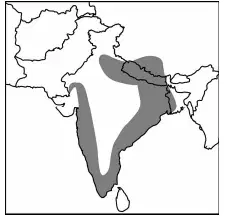
On the map above, the shaded area is most associated with which of the following types of agriculture?
Truck farming
Plantation agriculture
Slash-and-burn cultivation
Rice cultivation
Dairy farming

