
 Worksheets
Geography
Total questions: 16
Worksheet time: 8mins
Name
Class
Date
1.

What is the name of Continent #4
a)
Australia
b)
Africa
c)
South America
d)
Asia
2.

Name the ocean labeled letter B
a)
Arctic
b)
Pacific
c)
Southern
d)
Atlantic
3.

Identify continent #6.
a)
North America
b)
Asia
c)
Pacific
d)
Arctic
4.

Name the 0 ° line of Longitude.
a)
Greenwich
b)
Equator
c)
Prime Meridian
d)
Hull Street
5.

Identify the Continent with the number 1.
a)
North America
b)
Eurasia
c)
South America
d)
Africa
6.

Name the 0° line of Latitude.
a)
Prime Meridian
b)
Latitude
c)
Equator
d)
Hull Street
7.
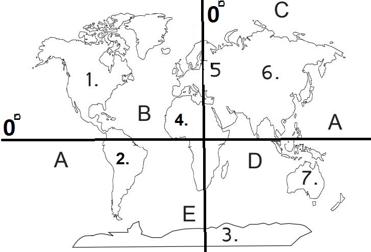
Which ocean is labeled D?
a)
Southern
b)
Arctic
c)
Pacific
d)
Indian
8.

Which ocean is labeled C?
a)
Indian
b)
Arctic
c)
Pacific
d)
Southern
9.
Which ocean is labeled A?
a)
Indian
b)
Arctic
c)
Pacific
d)
Southern
10.

The Prime Meridian divides the Earth into ___________ and ________ hemispheres.
a)
Eastern and Western
b)
Northern and Southern
c)
Southern and Eastern
d)
Northern and Western
11.

The Equator divides the Earth into __________ and __________ hemispheres.
a)
Northern and Eastern
b)
Southern and Northern
c)
Eastern and Western
d)
Southern and Western
12.

These are the names of the imaginary, parallel lines that circle the Earth.
a)
Lines of Longitude
b)
Lines of Latitude
c)
Lines of Hemisphere
d)
Equators.
13.
These are imaginary vertical lines that run north and south around the globe and touch at the North and South Poles.
a)
Lines of Hemispheres
b)
Lines of Latitude
c)
Lines of Longitude
d)
Prime Meridians
14.
What is the name of the map symbol we use to show the directions of North, South, East, and West?
a)
Globe
b)
Legend
c)
Coordinates
d)
Compass Rose
15.

Name the continent labeled with the number 5.
a)
Europe
b)
North America
c)
Africa
d)
Asia
16.

Name the continent with the number 2.
a)
Africa
b)
North America
c)
South America
d)
Asia
100 %

