
NEW
Font size
S
M
L
XL
 Worksheets
Geography
Total questions: 33
Worksheet time: 30mins
Name
Class
Date
1.
Which continent is farthest to the south?
a)
Africa
b)
Australia
c)
South America
d)
Antarctica
2.
Latitude lines measure...
a)
north and south
b)
east and west
3.
0o latitude is called the...
a)
Prime Meridian
b)
equator
c)
International Date Line
d)
Tropic of Capricorn
4.
0o longitude is called the...
a)
Prime Meridian
b)
equator
c)
International Date Line
d)
Tropic of Capricorn
5.

The lines on the globe represent lines of...
a)
longitude
b)
latitude
c)
meridians
d)
hemispheres
6.

Which hemisphere is shaded dark on the map?
a)
northern hemisphere
b)
southern hemisphere
c)
eastern hemisphere
d)
western hemisphere
7.
Which ocean is east of the United States?
a)
Atlantic
b)
Pacific
c)
Indian
d)
Arctic
8.
The ocean that flows around antarctica is the ...
a)
Atlantic Ocean
b)
Pacific Ocean
c)
Indian Ocean
d)
Southern Ocean
9.
Which hemispheres are Virginia in?
a)
northern and western
b)
northern and eastern
c)
southern and western
d)
southern and eastern
10.
the northern-most ocean in the world
a)
Arctic Ocean
b)
Atlantic Ocean
c)
Pacific Ocean
d)
Indian Ocean
11.

What is the continent that is pink?
a)
North America
b)
South America
c)
Asia
d)
Australia
12.

What is the continent that is red?
a)
North America
b)
Europe
c)
Africa
d)
Australia
13.

What is the continent that is orange?
a)
Africa
b)
Australia
c)
Antarctica
d)
Asia
14.

What is the continent that is yellow?
a)
Africa
b)
Australia
c)
Asia
d)
Antarctica
15.

Which mountain range separates Europe from Asia?
a)
Ural Mountains
b)
Pyrenees Mountains
c)
Alps Mountains
d)
Rocky Mountains
16.

Which river flows from the Alps mountains east across much of Europe and empties into the Black Sea?
a)
Rhine River
b)
Danube River
c)
Amazon River
d)
Volga River
17.

Which mountain range does the Danube and Rhine rivers begin in?
a)
Pyrenees Mountains
b)
Alps Mountains
c)
Rocky Mountains
d)
Ural Mountains
18.

What is the name of this tiny country?
a)
France
b)
Germany
c)
Russia
d)
Belgium
19.

Which country is highlighted on the map?
a)
Germany
b)
England
c)
France
d)
Belgium
20.

This river begins in the Alps mountains and flows north to the North Sea
a)
Danube River
b)
Volga River
c)
Nile River
d)
Rhine River
21.
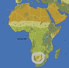
What physical feature is highlighted?
a)
Kalahari Desert
b)
Sahara Desert
c)
Niger River
d)
Lake Victoria
22.

What physical feature is highlighted?
a)
Ethiopian Highlands
b)
Mt. Kilimanjaro
c)
Niger River
d)
Atlas Mountains
23.

What physical feature is highlighted?
a)
Zambezi River
b)
Congo Basin
c)
Sahara Desert
d)
Nile River
24.
What are the two deserts in Africa
a)
Nafud and Arabian
b)
Death Valley and Sahara
c)
Sahara and Kalahari
d)
Kalahari and Death Valley
25.

What physical feature is highlighted on the map?
a)
Mt. Kilimanjaro
b)
Congo River
c)
Atlas Mountains
d)
Niger River
26.

What physical feature is shown here?
a)
Gobi Desert
b)
Himalayan mountains
c)
Taklimakan Desert
d)
Yangtze River
27.

What river is featured in red here?
a)
Yangtze River
b)
Ganges River
c)
Huang He River
d)
Indus River
28.

What river is featured here?
a)
Indus River
b)
Ganges River
c)
Yangtze River
d)
Huang He River
29.

What physical feature lies north of the Himalayas and west of the Gobi Desert?
a)
Sea of Japan
b)
Korean Peninsula
c)
Taiwan
d)
Taklimakan desert
30.

What river is highlighted here in dark yellow?
a)
Indus
b)
Ganges
c)
Yangtze
d)
Huang He
31.

Which letter identifies Saudi Arabia?
a)
A
b)
B
c)
C
d)
D
32.

Which letter identifies Iraq?
a)
A
b)
B
c)
C
d)
D
33.

Which letter identifies Israel?
a)
A
b)
B
c)
C
d)
D
Reset

