
 Worksheets
U7 Exam OLD TOPICS (for Tuesday)
Total questions: 37
Worksheet time: 1hrs 3mins
Name
Class
Date
1.

What is the elevation of point B?
a)
800 ft
b)
850 ft
c)
900 ft
d)
1000 ft
2.
What is the HIGHEST POSSIBLE elevation of point X?
a)
1600 ft
b)
1700 ft
c)
1699 ft
d)
1601 ft
3.

What is the elevation of Y?
a)
Between 120-140 meters
b)
Between 100-120 meters
c)
Between 140-160 meters
d)
Between 80-100 meters
4.

Which has the steepest gradient?
a)
B to C
b)
D to A
c)
K to E
d)
M to N
5.

Determine the contour interval:
a)
5 m
b)
10 m
c)
15 m
d)
20 m
6.
What do contour lines that are farther apart represent?
a)
a flat gradient
b)
a steep gradient
c)
a gentle gradient
d)
none of these
7.

Which topographic map matches profile C?
a)
1
b)
2
c)
3
d)
4
8.

What is the profile view to Topographic Map #1?
a)
A
b)
B
c)
C
d)
D
9.

What is the profile view to Topographic Map #2?
a)
B
b)
C
c)
D
d)
E
10.

Determine the contour interval used to draw this map.
a)
5 m
b)
10 m
c)
15 m
d)
20 m
11.
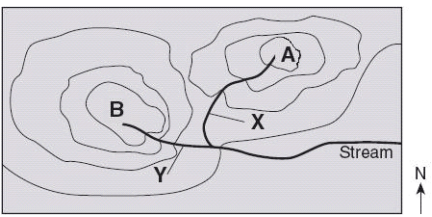
Which direction is the river labeled "Stream" flowing?
a)
northward
b)
southward
c)
westward
d)
eastward
12.

DAY 014
(p. 63) - The weather station model below shows some of the weather data for a certain location. What is the wind speed shown on the station model and which instrument is used to measure the wind speed?
(p. 63) - The weather station model below shows some of the weather data for a certain location. What is the wind speed shown on the station model and which instrument is used to measure the wind speed?
a)
15 knots, measured by a wind vane
b)
15 knots, measured by an anemometer
c)
25 knots, measured by a wind vane
d)
25 knots, measured by an anemometer
13.

DAY 014
(p. 63) - The weather station model below shows atmospheric conditions at Oswego, New York. How does the data on the station model indicate a high relative humidity?
(p. 63) - The weather station model below shows atmospheric conditions at Oswego, New York. How does the data on the station model indicate a high relative humidity?
a)
The temperature is far from the dewpoint
b)
It is raining
c)
There is 100% cloud cover
d)
all of these
14.

DAY 014 CW (p. 63)
( T or F ) The diagram shown is called a weather balloon model, and it shows winds from the northeast.
( T or F ) The diagram shown is called a weather balloon model, and it shows winds from the northeast.
a)
True
b)
False
15.
DAY 014 CW (p. 63)
( T or F ) In the diagram shown, the wind speed is 25 knots and cloud cover is about 50%.
( T or F ) In the diagram shown, the wind speed is 25 knots and cloud cover is about 50%.
a)
True
b)
False
16.

DAY 014 CW (p. 63)
( T or F ) In the diagram shown, one reason we know it has high relative humidity are that the numbers 29 and 31 are close to each other.
( T or F ) In the diagram shown, one reason we know it has high relative humidity are that the numbers 29 and 31 are close to each other.
a)
True
b)
False
17.
DAY 014 CW (p. 63)
( T or F ) In the diagram shown, the present weather conditions are rainy and 100% cloud cover.
( T or F ) In the diagram shown, the present weather conditions are rainy and 100% cloud cover.
a)
True
b)
False
18.

DAY 014 Exit Task (p. 64)
What is the percentage of cloud cover for station B?
What is the percentage of cloud cover for station B?
a)
100%
b)
75%
c)
50%
d)
0%
19.
DAY 014 Exit Task (p. 64)
State the present weather indicated by the present weather symbol at station C.
State the present weather indicated by the present weather symbol at station C.
a)
rain
b)
snow
c)
rain showers
d)
drizzle
20.

DAY 014 Exit Task (p. 65)
What is the percentage of cloud cover for station B?
What is the percentage of cloud cover for station B?
a)
0%
b)
75%
c)
50%
d)
100%
21.

DAY 017 CW (p. 83)
Which station model shows an air temperature of 75°F and a barometric pressure of 996.3 mb?
Which station model shows an air temperature of 75°F and a barometric pressure of 996.3 mb?
a)
(1)
b)
(2)
c)
(3)
d)
(4)
22.
DAY 017 CW (p. 83)
Encode the following air pressure into the code shown on a weather station model: 968.2 mb.
Encode the following air pressure into the code shown on a weather station model: 968.2 mb.
a)
968
b)
068
c)
982
d)
682
23.
DAY 017 CW (p. 83)
Encode the following air pressure into the code shown on a weather station model: 1002.1 mb.
Encode the following air pressure into the code shown on a weather station model: 1002.1 mb.
a)
100
b)
1002
c)
102
d)
021
24.
DAY 017 CW (p. 83)
Encode the following air pressure into the code shown on a weather station model: 992.1 mb.
Encode the following air pressure into the code shown on a weather station model: 992.1 mb.
a)
992
b)
092
c)
991
d)
921
25.
DAY 017 CW (p. 83)
Encode the following air pressure into the code shown on a weather station model: 1000.0 mb.
Encode the following air pressure into the code shown on a weather station model: 1000.0 mb.
a)
100
b)
1000
c)
0000
d)
000
26.
DAY 017 CW (p. 83)
Convert the following encoded air pressure from a station model into the actual barometric pressure: 799
Convert the following encoded air pressure from a station model into the actual barometric pressure: 799
a)
799.0 mb
b)
979 mb
c)
979.9 mb
d)
1079.9 mb
27.
DAY 017 CW (p. 83)
Convert the following encoded air pressure from a station model into the actual barometric pressure: 180
Convert the following encoded air pressure from a station model into the actual barometric pressure: 180
a)
918.0 mb
b)
1018.0 mb
c)
180.0 mb
d)
9180.0 mb
28.
DAY 017 CW (p. 83)
Convert the following encoded air pressure from a station model into the actual barometric pressure: 001
Convert the following encoded air pressure from a station model into the actual barometric pressure: 001
a)
9.001 mb
b)
1000.1 mb
c)
10.001 mb
d)
900.1 mb
29.
DAY 017 CW (p. 83)
Convert the following encoded air pressure from a station model into the actual barometric pressure: 988
Convert the following encoded air pressure from a station model into the actual barometric pressure: 988
a)
988.0 mb
b)
10.988 mb
c)
1098.8 mb
d)
998.8 mb
30.

DAY 017 Exit Task (p. 86)
What is the barometric pressure indicated by this station model?
What is the barometric pressure indicated by this station model?
a)
0.029 mb
b)
902.9 mb
c)
1002.9 mb
d)
1029.0 mb
31.

DAY 017 Exit Task (p. 86)
What was the actual barometric pressure, according to the station model, to the nearest tenth of a millibar?
What was the actual barometric pressure, according to the station model, to the nearest tenth of a millibar?
a)
0.021 mb
b)
902.1 mb
c)
1002.1 mb
d)
1021.0 mb
32.

DAY 018 HW (p. 97)
Various weather conditions at LaGuardia Airport in New York City are shown on the station model shown. What were the barometric pressure and weather conditions at the airport at the time of the observation?
Various weather conditions at LaGuardia Airport in New York City are shown on the station model shown. What were the barometric pressure and weather conditions at the airport at the time of the observation?
a)
914.6 mb of pressure and smog
b)
914.6 mb of pressure and a clear sky
c)
1014.6 mb of pressure and smog
d)
1014.6 mb of pressure and a clear sky
33.

Using the map scale, you measured the line segment at 3 km. What is the gradient of the slope marked by the line?
[HINT: Gradient = (change in field value)/(distance)]
[HINT: Gradient = (change in field value)/(distance)]
a)
200 m/km
b)
200 km
c)
0.333 m/km
d)
0.333 km
34.

Using the map scale and scrap paper, you measured the distance between C and D to be 20 km. What is the gradient between points C and D?
[HINT: Gradient = (change in field value)/(distance)]
[HINT: Gradient = (change in field value)/(distance)]
a)
400 m/km
b)
20 km
c)
20 m/km
d)
400 km
35.

Using the map scale and scrap paper, you measured the distance between X and Y to be 1.7 miles.
What is the gradient between points X and Y?
[HINT: Gradient = (change in field value)/(distance)]
What is the gradient between points X and Y?
[HINT: Gradient = (change in field value)/(distance)]
a)
294 ft/mi
b)
0.0034 ft/mi
c)
294
d)
0.0034
36.

The topographic map below shows locations X and Y.
What is the approximate gradient between X and Y? [HINT: Use the EQUATION on your ESRT]
What is the approximate gradient between X and Y? [HINT: Use the EQUATION on your ESRT]
a)
15 ft/mi
b)
20 ft/mi
c)
30 ft/mi
d)
60 ft/mi
37.

What is the difference in elevation between Point X and Point Y?
a)
120 m
b)
240 m
c)
360 m
d)
340 m
100 %

