
 Worksheets
Political Geography
Total questions: 35
Worksheet time: 18mins
Which of the following is NOT part of the definition of a state?
A permanent resident population
A common language
Defined territorial boundaries
Political sovereignty
Which of the following best illustrates the geographical concept of the nation-state?
Iceland
Belguim
India
Canada
A group of people who share a common culture and identity as a cohesive group is a called a
Nation
Nation-State
Country
Sovereign State
What is the largest state in the world by land size?
Canada
China
Russia
United States
A shared religion and a common language tend to unify people. Since they unify people, shared religion and common language are examples of
centripetal forces
centrifugal forces
bonding forces
supranational forces
What is Balkanization?
the break up of a region or country into smaller regions or countries
the idea that ethnicities have the right to govern themselves
the incorporation of a territory into another country
the process of redrawing legislative boundaries for the purpose of benefiting the political party in power
Which of the following groups represents a nation without a state?
Kurds
Israelis
Turks
Germans

Type of State
Compact
Fragmented
Perforated
Elongated

Type of State
Prorupted
Perforated
Compact
Landlocked

Type of State
Prorupted
Perforated
Compact
Fragmented

Type of State
Elongated
Perforated
Prorupted
Fragmented

Ex. South Africa
Perforated State
Exclave
Prorupted State
Enclave
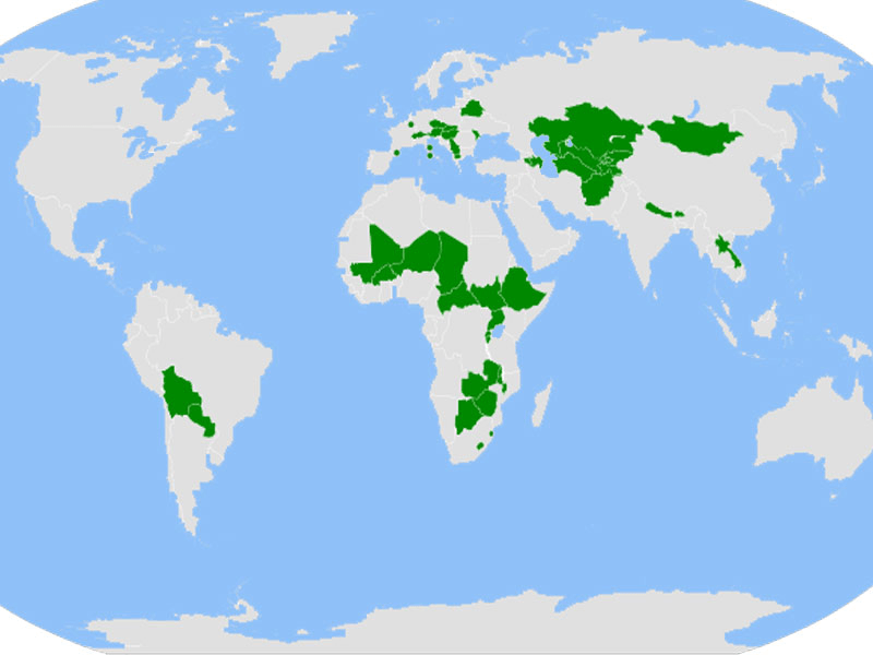
Which characteristic do all the nations seen here share?
All are compact
All are landlocked
All are federal states
All are members of the European Union (EU)
This type of state is the simplest to manage, since the government is close to all portions of the state.
Elongated
Compact
Landlocked
Fragmented

Ex. Vatican City
Enclave
Exclave
Superimposed state
Geometric state
TERM: Ability of a state to carry out actions & policies within its borders independent of outside interference
Sovereignty
Territoriality
Gerrymandering
Nationality
The Berlin Wall fell in 1989, but people in the former East & West Germany still feel its influence. Where the wall once stood now acts as a
superimposed boundary
relict boundary
antecedent boundary
subsequent boundary
Boundaries established by rivers, oceans, deserts, mountains, etc.
Geographic
Superimposed
Geometric
Physical
Which type of boundary would use lines of latitude and longitude?
Antecedent
Subsequent
Geometric
Relic
Boundaries set by ethnic differences, especially those based on language and religion
Physical
Cultural
Political
Antecedent
Boundary which was established before an area was populated. Many times these boundaries were made along physical geographic features
Geometric Boundary
Antecedent Boundary
Superimposed Boundary
Physical Boundary

Type of Boundary
Geometric
Cultural
Linear
Physical
Conflicts often occur on borders because ...
direct, physical contact often takes place between two neighboring states
direct, physical contact never takes place between two neighboring states
boundary lines are invisible
boundary lines are carefully drawn between different cultures
The boundaries of congressional districts of the United States are
redrawn whenever a member of Congress feels his or her constituency has changed.
redrawn after every presidential election
drawn to cross over state boundaries.
redrawn every ten years.
What is a superimposed boundary?
Boundaries forced upon an existing cultural landscape by a colonial or political power without regard for cultural barriers
Boundaries forced upon a new landscape without regard for physical boundaries
The study of the political organization (borders) of the planet
Boundaries based on the elements of the natural or physical landscape
Most of Africa’s political boundaries were originally drawn by
seventeenth-century European explorers.
UN peacekeeping missions in the 1950s and 1960s.
decolonization movements of the 1950s and 1960s.
European colonial powers in the late-nineteenth century.
TERM: politically redistricting that produces unusually shaped districts to create a political advantage
Redlining
Gentrification
Politicization
Gerrymandering
The European Union (EU) and United Nations (UN) are both examples of
military alliances
multinational states
confederations
supranational organizations

What do the state represented above all have in common?
They are unitary states
They are formerly communist states
They are federal states
They are satellite states
An internal organization of a state that places most power in the hands of central government officials
Federal state
Sovereign state
Nation
Unitary state
Friedrich Ratzel's conception that the state is similar to a biological organism with a birth to maturity to death life cycle
Conquest Theory
Heartland Theory
Rimland Theory
Organic Theory
According to Mackinder's heartland theory, which of the following countries would be most likely to dominate the globe?
Japan
United States
Russia
India

