
 Worksheets
Latin America
Total questions: 58
Worksheet time: 46mins
Name
Class
Date
1.

Which country is shown in green on the map?
a)
Venezuela
b)
Panama
c)
Bolivia
d)
Brazil
2.

Which country is shown in red on the map?
a)
Brazil
b)
Cuba
c)
Colombia
d)
Mexico
3.

Which physical feature stretches 4,500 miles along the west coast of South America?
a)
Sierra Madre Mountains
b)
Atacama Desert
c)
Amazon River
d)
Andes Mountains
4.

This man-made feature is important to trade.
a)
Amazon River
b)
Panama Canal
c)
Atacama Desert
d)
Caribbean Sea
5.

This country shares a border with the United States.
a)
Mexico
b)
Cuba
c)
Panama
d)
Boliva
6.

The country shown on the map is a leading producer of oil.
a)
Haiti
b)
Brazil
c)
Mexico
d)
Venezuela
7.

Which country is shown on this map?
a)
Haiti
b)
Cuba
c)
Bolivia
d)
Costa Rica
8.

This physical feature stretches the width of South America.
a)
Caribbean Sea
b)
Amazon River
c)
Andes Mountains
d)
Panama Canal
9.

This physical feature borders Mexico, the United States, and Cuba.
a)
Gulf of Mexico
b)
Caribbean Sea
c)
Pacific Ocean
d)
Atlantic Ocean
10.

The largest ocean borders North America, Central America, South America, and Asia.
a)
Pacific Ocean
b)
Atlantic Ocean
c)
Southern Ocean
d)
Indian Ocean
11.

This country is ______.
a)
Mexico
b)
Bolvia
c)
Colombia
d)
Venezuela
12.

This is the only land-locked country in South America.
a)
Venezuela
b)
Colombia
c)
Brazil
d)
Boliva
13.

Where do most Brazilian's live?
a)
In the interior
b)
Along the coast
c)
In the Amazon Rainforest
d)
Along the Amazon River
14.

What are the primary languages spoken in Latin America?
a)
English and French
b)
French and Spanish
c)
Spanish and Portuguese
d)
Spanish and English
15.

Which countries are included in the term Latin America?
a)
North America, including the West Indies
b)
Central & South America & the Caribbean
c)
all countries that speak Latin
d)
all the countries in North & South America
16.

The Panama Canal was built to ____.
a)
improve good feelings between countries
b)
provide a shortcut for trade
c)
to lower taxes
d)
improve mining techniques
17.

Venezuela is a world leader in the production of _____.
a)
Oil
b)
Sugar Cane
c)
Fish
d)
Lumber
18.

____ has the highest population in Latin America.
a)
Mexico
b)
Brazil
c)
Cuba
d)
Venezuela
19.

The quest for economic development comes mainly at the expense of _________ in Brazil.
a)
Polluted waterways
b)
Over-extraction of oil
c)
Overfishing
d)
Deforestation
20.

The Amazon Rainforest is located mainly in ______.
a)
Mexico
b)
Peru
c)
Brazil
d)
Amazonia
21.
Most, over 90%, of the population of Latin America belong to which of the following religions?
a)
Catholic
b)
Judaism
c)
Islam
d)
Shintoism
22.

Which Latin American country is highlighted on the map shown?
a)
Brazil
b)
Peru
c)
Mexico
d)
Venezuela
23.

Country?
a)
Uruguay
b)
Argentina
c)
Brazil
d)
Mexico
24.

???
a)
Argentina
b)
Paraguay
c)
Chile
d)
Uruguay
25.

The island of Hispaniola has what 2 countries on it?
a)
Russia and England
b)
Brazil and Peru
c)
Haiti and Dominican Republic
d)
Jamaica and The Bahamas
26.

Which country is labeled with a number 2.
a)
Belize
b)
Panama
c)
Guatemala
d)
Costa Rica
27.

Which country is labeled with the number 3?
a)
Belize
b)
Guatemala
c)
Mexico
d)
El Salvador
28.

Which country is labeled with a number 4?
a)
Mexico
b)
Belize
c)
El Salvador
d)
Costa Rica
29.

Which country is labeled with a number 5?
a)
Nicaragua
b)
Honduras
c)
Belize
d)
Guatemala
30.

Which country is labeled with a number 6?
a)
Honduras
b)
Nicaragua
c)
Costa Rica
d)
Panama
31.

Which country is labeled with a number 12?
a)
Dominican Republic
b)
Puerto Rico
c)
The Bahamas
d)
Lesser Antilles
32.

What body of water is labeled with the blue 15?
a)
Pacific Ocean
b)
Caribbean Sea
c)
Gulf of Mexico
d)
Atlantic Ocean
33.

What body of water is labeled with a blue 17?
a)
Pacific Ocean
b)
Atlantic Ocean
c)
Caribbean Sea
d)
Gulf of Mexico
34.

Identify the country.
a)
Ecuador
b)
Paraguay
c)
Uruguay
d)
Bolivia
35.

Identify the country.
a)
Parguay
b)
Uruguay
c)
Ecuador
d)
Bolivia
36.

Identify the country.
a)
Uruguay
b)
Bolivia
c)
Brazil
d)
Paraguay
37.

What country is being displayed in red?
a)
Cuba
b)
The Bahamas
c)
Haiti
d)
Panama
38.

What country is being displayed in red?
a)
Haiti
b)
Dominican Republic
c)
Puerto Rico
d)
Costa Rica
39.

What country is being displayed in red?
a)
Nicaragua
b)
Puerto Rico
c)
Honduras
d)
Costa Rica
40.

This is a map of what country, whose capital is Kingston?
a)
Trinidad and Tobago
b)
Venezuela
c)
Puerto Rico
d)
Jamaica
41.

This is a map of what country, whose capital is Caracas?
a)
Argentina
b)
Venezuela
c)
Mexico
d)
Colombia
42.

This is a map of what country, whose capital is Nassau?
a)
Puerto Rico
b)
Trinidad and Tobago
c)
Bahamas
d)
Mexico
43.

This is a map of what country, whose capital is San Juan?
a)
Puerto Rico
b)
Trinidad and Tobago
c)
Bahamas
d)
Venezuela
44.

4 is which of the following physical features?
a)
Pampas
b)
Mexican Peninsula
c)
Sierra Madre Occidental
d)
Yucatan Peninsula
45.

1 is which of the following physical features?
a)
Amazon River
b)
Mississippi River
c)
Rio Grande River
d)
Yellow River
46.

12 is which of the following physical features?
a)
Cape Horn
b)
American Peninsula
c)
Cape of Good Hope
d)
Peninsula of Argentina
47.
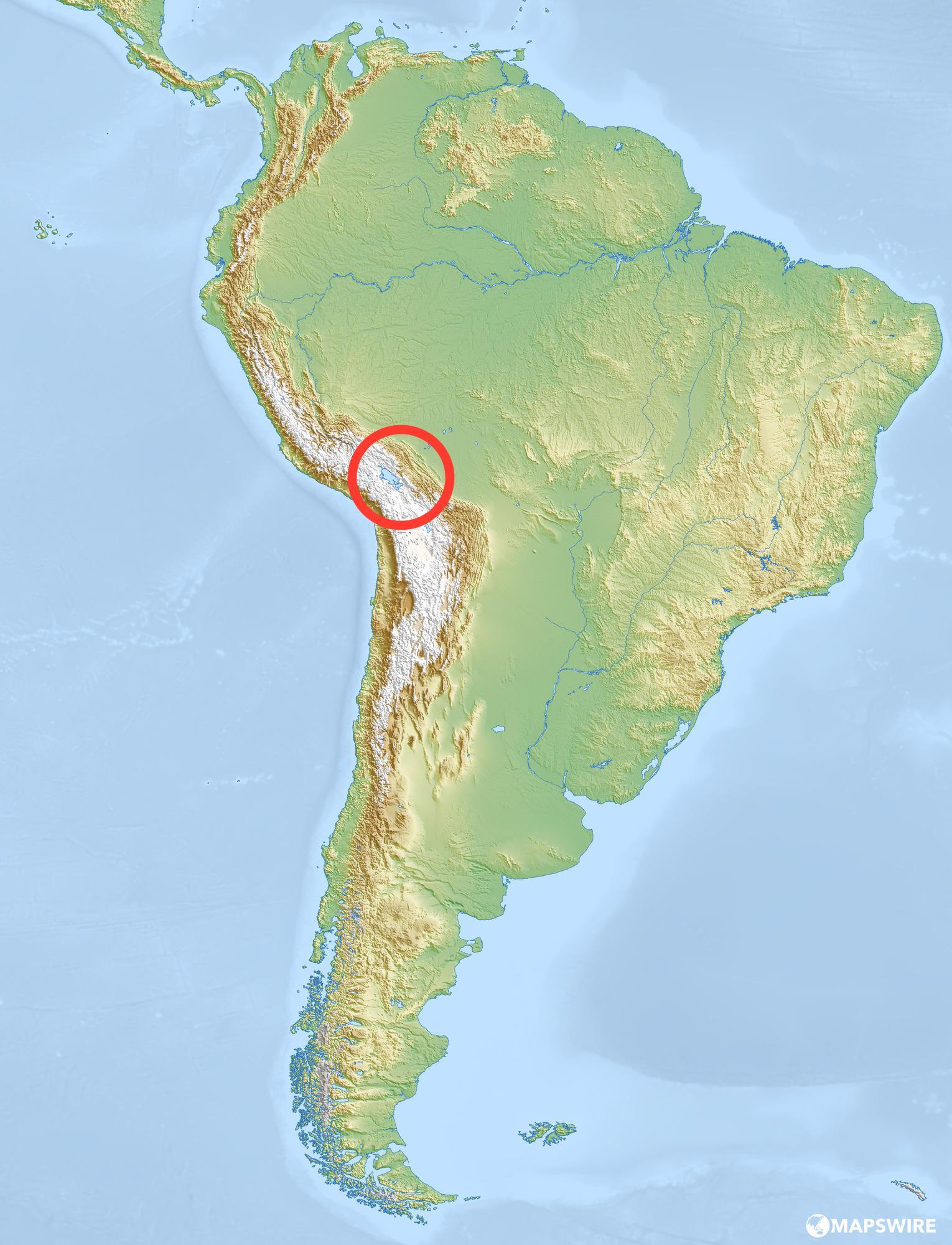
What lake is this?
a)
Lake Maracaibo
b)
Lake Titicaca
c)
Andes Mountains
d)
Amazon River
48.

a)
Gulf of Mexico
b)
Gulf of California
c)
Caribbean Sea
d)
Gulf of St. Lawrence
49.

a)
Cuba
b)
Haiti
c)
Puerto Rico
d)
Jamaica
50.

a)
Belize
b)
Costa Rica
c)
Panama
d)
Nicaragua
51.

The Galapagos Islands lie in ...
a)
the Silent Ocean
b)
the Atlantic Ocean
c)
the Indian Ocean
d)
the Pacific Ocean
52.

a)
Prime Meridian
b)
Tropic of Capricorn
c)
Equator
d)
Tropic of Cancer
53.

a)
Uruguay
b)
Equator
c)
Falkland Islands
d)
Trinidad and Tobago
54.
Where is Cozumel situated?
a)
Just off Campeche
b)
Just off the yucatan Peninsula
c)
Just off Guatemala.
55.

I represents what physical feature?
a)
Orinoco River
b)
Paraguay River
c)
Straight of Bosporus
d)
Straight of Magellan
56.
Which of the following accurately lists the Brazilian cities from north to south?
a)
Brasilia, Rio de Janeiro, Sao Paulo
b)
Sao Paulo, Rio de Janeiro, Brasilia
c)
Brasilia, Sao Paulo, Rio de Janeiro
d)
Rio de Janeiro, Brasilia, Sao Paulo
57.

a)
Atacama Desert
b)
The Andes
c)
The West Indies
d)
La Pampa
58.

Along with the West Indies, this other region faces the greatest risks from hurricanes, since it is also near the Caribbean Sea.
a)
Yucatan Peninsula
b)
La Pampa
c)
Brazilian Highlands
d)
Atacama Desert
100 %

