wayground logo

Free Printable Worksheets

NEW

Font size

S
M
L
XL
Worksheets

The Atmosphere

Total questions: 60

Worksheet time: 42mins

Name
Class
Date
1.
Surface currents are a result of
a)
Global Wind Patterns
b)
Earth's Revolution
c)
Salt
d)
All choices
2.
A strong surface current that runs along the east coast of the United States and carries warm water to Europe.
a)
California Current
b)
Global Conveyor Belt
c)
Gulf Stream
d)
Surface Current
3.

A horizontal movement of ocean water that is caused by wind and that occurs at or near the ocean's surface.

a)

deserts

b)

Global Conveyor Belt

c)

Surface Current

d)

upward moving air

4.
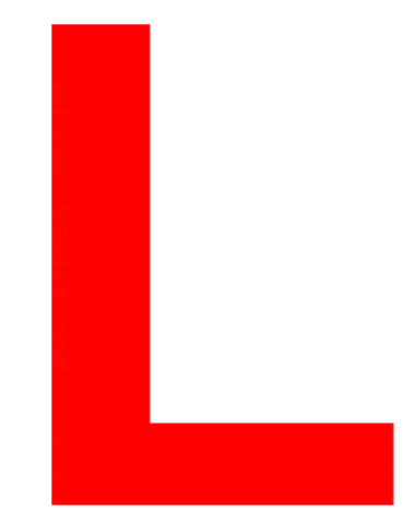
What does this symbol on a weather map indicate? 
a)
High pressure system
b)
Low pressure system
c)
Cold front
d)
Warm front
5.
What does this symbol indicate on a weather map? 
a)
High pressure system
b)
Low pressure system
c)
Cold front
d)
Warm front
6.

What kind of weather is usually associated with a high pressure system?

a)

Sunny weather

b)

Precipitation (rain, snow, etc.)

c)

Blizzard conditions

d)

Tornado warning

e)

Tornado watch

7.
Which weather tool measures air pressure?
a)
thermometer
b)
barometer
c)
anemometer
d)
psychrometer
8.
This weather tool measures wind speed and direction
a)
thermometer
b)
barometer
c)
anemometer
d)
psychrometer
9.
Which weather tool measures temperature?
a)
thermometer
b)
barometer
c)
psychrometer
d)
anememeter
10.
The boundary  between two air masses is known as:
a)
front
b)
storm
c)
climate
d)
flood
11.
Which type of cloud is most often observed during a thunderstorm?
a)
cirrus
b)
stratus
c)
cumulus
d)
cumulonimbus
12.

Which condition usually means cloudy, stormy weather?

a)

high pressure

b)

low pressure

c)

global winds

d)

tornado watch

13.

What type of cloud is this that bring potentially hazardous weather?

a)

nimbostratus cloud

b)

cumulonimbus cloud

c)

cirrocumulus cloud

d)

altostratus cloud

14.

What does this symbol represent on a weather map?

a)

warm front

b)

cold front

c)

stationary front

d)

occluded front

15.
What does this symbol on a weather map indicate? 
a)
High pressure system
b)
Low pressure system
c)
Cold front
d)
Warm front
16.
A _____ is a large, swirling, low-pressure system that forms over the Atlantic Ocean.
a)
blizzard
b)
cold front
c)
tornado 
d)
hurricane
17.

A violently rotating column of air is called a _____ when it comes in contact with the ground.

a)

hurrican

b)

tornado

c)

trade wind

d)

local wind

18.
Rain, snow, sleet, and hail are all forms of _____.
a)
precipitation
b)
condensation
c)
evaporation
d)
climate
19.
The amount of water vapor present in the air is called ________________.
a)
weather
b)
humidity
c)
air mass
d)
dew point
20.
When a warm air mass gently slides on top of a cold air mass, and you have drizzly rain and then warmer weather, what type of front is it?
a)
warm front
b)
cold front
c)
occluded front
d)
stationary front
21.
What type of storm front is this? 
a)
warm front
b)
cold front
c)
stationary front
d)
occluded front
22.

When severe weather conditions are present, a _______ is issued

a)

watch

b)

warning

c)

advisory

d)

seek shelter

23.

Why do hurricanes inflict more damage than tornadoes?

a)

they are larger

b)

longer duration

c)

bring flooding and strong rains

d)

can create tornadoes

e)

all of these are true

24.

This is the scale by which tornadoes are measured

a)

Enhanced Fujita

b)

Excellent Ferrari

c)

Enrico Fermi

d)

Enticing Fajitas

e)

Entertaining Father

25.
What causes warm air to rise?
a)
the fact that it's less dense than cold air 
b)
The fact that it weighs more than cold air 
c)
The fact that it has higher pressure than cold
d)
the fact that its more dense than cold air 
26.
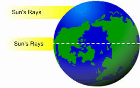
Which term best describes how the earth's atmosphere is heated?
a)
Spirally
b)
Unevenly
c)
Circularly
d)
Kinetically
27.
What creates the air pressure difference between the equator and the poles?
a)
The length of the seasons
b)
The shape of the earth 
c)
the duration of the solar year
d)
The amount of direct sunlight each area receives 
28.
How do jet streams influence the weather? 
a)
by creating clouds 
b)
by increasing the moisture in the atmosphere 
c)
by moving weather from one area to another very quickly 
d)
by drying out the atmosphere 
29.
When heat rises cools then sinks 
a)
high pressure 
b)
convection current 
c)
low pressure 
d)
stratospheric pressure  
30.

All wind are caused by differences in ____________.

a)

weather

b)

precipitation

c)

air pressure

d)

climate

31.

Most differences in air pressure are caused by _______________ heating of the atmosphere.

a)

some

b)

equal

c)

unequal

d)

great

32.

Wind direction is determined with a _____________.

a)

thermometer

b)

anemometer

c)

satellite

d)

wind vane

33.

It takes _________ energy to warm up a body of water than it does to warm up an equal area of land.

a)

some

b)

equal

c)

less

d)

more

34.

A wind that blows from an ocean or lake onto the land is known as a _________.

a)

sea breeze

b)

desert breeze

c)

cold wind

d)

warm wind

35.

The flow of air from land to a body of water is called a ___________________

a)

warm breeze

b)

lake breeze

c)

land breeze

d)

wind breeze

36.
Weather conditions and patterns can be predicted based on weather data collected from various sources.  I am the source used to see cloud patterns and movement.  What am I?
a)
isobars
b)
radar
c)
satellite
d)
isotherms
37.
I am the source used to detect cloud cover, rainfall, or storm location, intensity, and movement, and the potential for severe weather.  What am I?
a)
isotherm
b)
radar
c)
satellite
d)
isobars
38.
I am the weather tool that measures relative humidity (the amount of water vapor in the air).  What am I?
a)
anemometer
b)
barometer
c)
sling psychrometer
d)
wind vane
39.
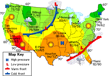
A cold front is approaching Minneapolis. What will happen to the air temperature?
a)
stay the same
b)
increase
c)
decrease
40.
A low pressure system is located over Georgia. What type of weather will they have?
a)
clear, sunny skies
b)
cloudy and rainy
41.

What kind of front is shown?

a)

cold

b)

warm

c)

stationary

d)

occluded

42.
Which city is experiencing thunderstorms?
a)
Denver
b)
New York 
c)
Miami 
d)
Boise
43.
a)
High Air Pressure
b)
High Temperatures
c)
Heavy Rain
d)
Hail
44.
What front is moving through
Alabama and Georgia? 
a)
Warm
b)
Occluded
c)
Stationary
d)
Cold
45.

The cold front is moving

a)

east and southeast

b)

west and northwest

c)

north

d)

south

46.

When a cold front moves in

a)

it forces warm air to rise rapidly creating big clouds and likely rain

b)

it pushes against warm air and becomes a stationary front

c)

the cold air goes above the warm air causing a clear sky

d)

it forms a wedge and the warm air slowly rises and may form small clouds

47.
Which is most likely an effect of the Gulf Stream?
a)
heavy rains in California
b)
severe drought in Australia
c)
milder winter temperatures in Florida
48.
How does the Gulf Stream impact hurricane development off the coast of the southeastern United States?
a)
Colder water from the Gulf Stream increases the speed and intensity of the hurricane.
b)
Colder water from the Gulf Stream decreases the speed and intensity of the hurricane.
c)
Warmer water from the Gulf Stream increases the speed and intensity of the hurricane.
d)
Warmer water from the Gulf Stream decreases the speed and intensity of the hurricane.
49.

Why do air temperatures vary over bodies of water and land masses?

a)

because water can hold more heat than land

b)

because water receives more sunlight than land

c)

because winds move faster over land than over water

d)

because water temperatures are colder than land temperatures lessActions

50.
Which is most responsible for guiding the movement of different air masses across the United States?
a)
the oceans
b)
trade winds
c)
the jet stream
d)
easterly winds
51.
The Gulf stream carries _____________ water from the east coast of The United States to the West coast of Europe.
a)
Cold
b)
Warm 
c)
Freezing
d)
Fresh
52.
Air moves from _______ pressure to _______ pressure.
a)
Low, High
b)
High, Low
c)
Warm, Cold
d)
Cold, Warm
53.
Water travels in definite paths around the ocean called
a)
Highways
b)
Currents
c)
Rivers
d)
Streams
54.

What is the source of energy that causes wind?

a)

mechanical energy

b)

the Moon

c)

uneven heating of Earth's surface

d)

solar energy

e)

atomic energy

55.

You notice that the air pressure increased along with a temperature drop in Carrollton. What would cause this to happen?

a)

a cold front came through the area

b)

a warm front came through the area

c)

a stationary front came through the area

d)

a jet stream came through the area

56.

Why would Florida have more thunderstorm days than Texas?

a)

its the furthest state to the east

b)

it is surrounded by warm water on 3 sides

c)

the entire state is at sea level

d)

its a long, narrow state

e)

its not as big as Texas

57.

What would you expect to find on the windward side of a mountain?

a)

frozen land

b)

more vegetation

c)

a desert

d)

Antarctica

e)

a lake

58.

In order for a hurricane to form, what must it have?

a)

cooler ocean waters

b)

hot land

c)

very warm ocean waters

d)

the arctic ocean

59.

How do large bodies of water modify nearby land climate?

a)

they cannot change climate

b)

moderate the weather

c)

increases the amount carbon dioxide in the air

d)

causes the water to change temperature more quickly

60.

Which of the following is a true statement?

a)

Land temperature does not change, but ocean temperature does.

b)

Land and ocean temperatures change at the same rate.

c)

Land heats and cools quicker than the ocean does.

d)

Land heats and cools more slowly than water.

e)

Coastal area temperature don't change but inland it does.