
 Worksheets
Geography Review
Total questions: 46
Worksheet time: 4hrs 50mins
Name
Class
Date
1.

Which two continents are located entirely in the Western Hemisphere?
a)
Europe and Africa
b)
Asia and Antarctica
c)
North America and Australia
d)
North America and South America
2.

What does a map’s scale compare?
a)
direction on a map with direction on Earth
b)
distance on a map with distance on Earth
c)
location on a map with location on a globe
d)
distortion on a map with distortion on a globe
3.
the northern-most ocean in the world
a)
Arctic Ocean
b)
Atlantic Ocean
c)
Pacific Ocean
d)
Indian Ocean
4.
imaginary line found at zero degrees latitude
a)
Isthmus
b)
Border
c)
Prime Meridian
d)
Equator
5.
the term for one-half of a globe or one-half of the planet Earth
a)
Sphere
b)
Legend
c)
Prime Meridian
d)
Hemisphere
6.
Largest continent in the world
a)
Africa
b)
United States
c)
Asia
d)
Europe
7.
imaginary line found at zero degrees longitude
a)
Prime Meridian
b)
Equator
c)
Longitude
d)
Latitude
8.
body of land surrounded by water on three sides
a)
Island
b)
Isthmus
c)
Peninsula
d)
Bay
9.
a tool on a map that shows cardinal directions and sometimes intermediate directions
a)
Compass Rose
b)
Rose Graph
c)
Legend
d)
Map Key
10.
Ocean found to the East of the United States
a)
Pacific
b)
Indian
c)
Atlantic
d)
Australian
11.

What is the continent that is pink?
a)
North America
b)
South America
c)
Asia
d)
Australia
12.

What is the continent that is blue?
a)
Africa
b)
Australia
c)
Antarctica
d)
Asia
13.

What is the continent that is red?
a)
North America
b)
Europe
c)
Africa
d)
Australia
14.

What is the continent that is dark green?
a)
North America
b)
South America
c)
Europe
d)
Australia
15.

What is the continent that is yellow?
a)
Africa
b)
Australia
c)
Asia
d)
Antarctica
16.

What is the continent that is orange?
a)
Africa
b)
Australia
c)
Antarctica
d)
Asia
17.

What is the continent that is light green?
a)
North America
b)
South America
c)
Africa
d)
Australia
18.
Name the imaginary line which divides Northern and Southern hemispheres
a)
Cardinal Direction
b)
South
c)
North
d)
Equator
19.
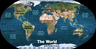
Which continent do we live on?
a)
North America
b)
South America
c)
Europe
d)
Asia
20.
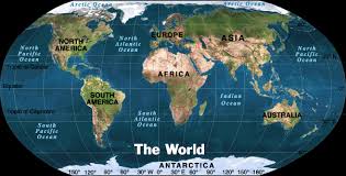
How would you describe Europe's location in relation to Asia
a)
Europe is located east of Aisa.
b)
Europe is located west of Asia.
c)
Europe is located south of Asia.
d)
Europe is located north of Asia
21.
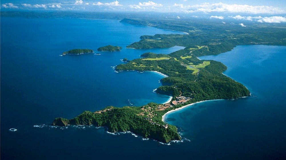
Define peninsula
a)
A piece of land that is bordered by water on all sides.
b)
an area that is higher than surrounding land
c)
low land between two mountains
d)
piece of land that is bordered on three sides but is connected to the mainland.
22.
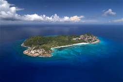
Define island...
a)
piece of land surrounded by water on 3 sides, but is connected to the mainland.
b)
water way with land on both sides
c)
large body of water surrounded by land
d)
piece of land completely surrounded by water
23.
Which field of social studies looks at past events?
a)
Geography
b)
History
c)
Economics
d)
Political Science
24.
Which field of social studies includes the creation of laws, upholding laws, and settlement of disagreement about laws?
a)
Geography
b)
History
c)
Culture
d)
Government
25.

Which field of social studies studies all that makes a group of people who they are?
a)
Culture
b)
History
c)
Government
d)
Political Science
26.
Which field of social studies focuses on the land and how people interact with the land?
a)
History
b)
Political Science
c)
Geography
d)
Government
27.
Which field of social studies focuses on how people manage their resources by producing, exchanging, and using goods and services?
a)
Political Science
b)
Economics
c)
History
d)
Geography
28.
A __________ tells you what each symbol on the map stands for.
a)
legal
b)
lobster
c)
legend
d)
langoustine
29.
The study of the Earth and the way people live and use it.
a)
Geology
b)
Genome
c)
Geography
d)
Geode
30.
A shape on the Earth's surface, such as a mountain or hill
a)
landform
b)
longitude
c)
latitude
d)
geography
31.
Which part of the map show the directions?
a)
Map Title
b)
Compass Rose
c)
Map key or legend
d)
Grid Lines
32.
Which imaginary line divides the Earth into the eastern and western hemispheres?
a)
Prime Meridian
b)
Equator
c)
Axis
d)
North Pole
33.
On which two hemispheres do we live?
a)
Northern and Eastern
b)
Eastern and Southern
c)
Western and Southern
d)
Northern and Western
34.
A political map shows ______
a)
Landforms
b)
Boundaries
c)
Government
d)
Rivers
35.

True or False: Is this a political Map?
a)
True
b)
False
36.
The 4 things a map needs are..
a)
oceans
b)
scale
c)
key
d)
title
e)
compass
37.
Which answer shows all of
the Intermediate Directions?
the Intermediate Directions?
a)
South, North, East, West
b)
North, Northeast, Northwest
c)
Northeast, Southeast, Northwest,
Southwest
Southwest
d)
South, Southeast, Southwest
38.
Which answer shows the tool we
use for cardinal and intermediate
directions?
use for cardinal and intermediate
directions?
a)
line of longitude
b)
compass rose
c)
map
d)
key
39.

What direction is indicated by the number 6?
a)
north
b)
east
c)
south
d)
west
40.

What direction is indicated by the number 2?
a)
north
b)
east
c)
south
d)
west
41.

What direction is indicated by the number 4?
a)
north
b)
east
c)
south
d)
west
42.
Which ocean is to the west of Africa?
a)
Atlantic
b)
Arctic
c)
Antarctica
d)
Pacific
43.
Mountains would be shown on what type of map?
a)
Political
b)
Physical
c)
Special Purpose
44.
State Capitals
a)
Political
b)
Physical
45.
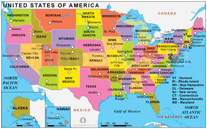
What type of Map is this
a)
Political
b)
Physical
c)
Special Purpose
46.
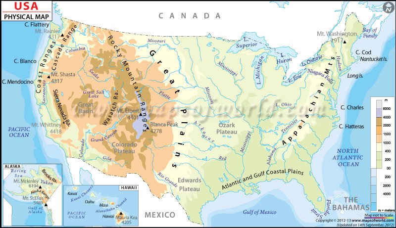
What type of Map is this
a)
Political
b)
Physical
c)
Special Purpose
100 %

