wayground logo

Free Printable Worksheets

NEW

Font size

S
M
L
XL
Worksheets

Maps!

Total questions: 34

Worksheet time: 42mins

Name
Class
Date
1.
Latitude lines run
a)
East to West
b)
North to South
2.
What is this object known as?
a)
map symbol
b)
map key
c)
map scale
d)
compass rose
3.
Which ocean meets the coast of South Carolina?
a)
Pacific Ocean
b)
Atlantic Ocean
c)
Arctic Ocean
d)
Indian Ocean
4.
How many oceans does Earth have? 
a)
2
b)
3
c)
4
d)
5
5.
Name Continent C!
a)
Antarctica
b)
Europe
c)
Asia
d)
North America
6.
Continent F is ________.
a)
Antarctica
b)
Australia
c)
Europe
d)
North America
7.
Continent G is ________.
a)
Asia
b)
Antarctica
c)
North America
d)
Europe
8.
Name Ocean #1!
a)
Indian
b)
Pacific
c)
Atlantic
d)
Southern
9.
A _______________ is exactly half of the earth.
a)
Equator
b)
Hemisphere
c)
Tropic of Cancer
d)
Arctic Circle
10.
What is a map scale?
a)
a tool to measure distance
b)
a tool to tell direction
c)
a tool to start a fire
d)
a tool to build a house
11.
Tells the subject of the map
a)
map key
b)
map scale
c)
map title
12.
What is this object known as?
a)
map symbol
b)
map key
c)
map scale
d)
compass rose
13.
What IS NOT a part of most maps?
a)
Compass Rose
b)
Title
c)
Symbols/Key
d)
People
14.
North, South, East and West are referred to as the _________directions.
a)
raven
b)
bluejay
c)
cardinal
d)
robin
15.
Which direction normally is pointing to the top of the page on a map?
a)
North
b)
South
c)
East
d)
West
16.
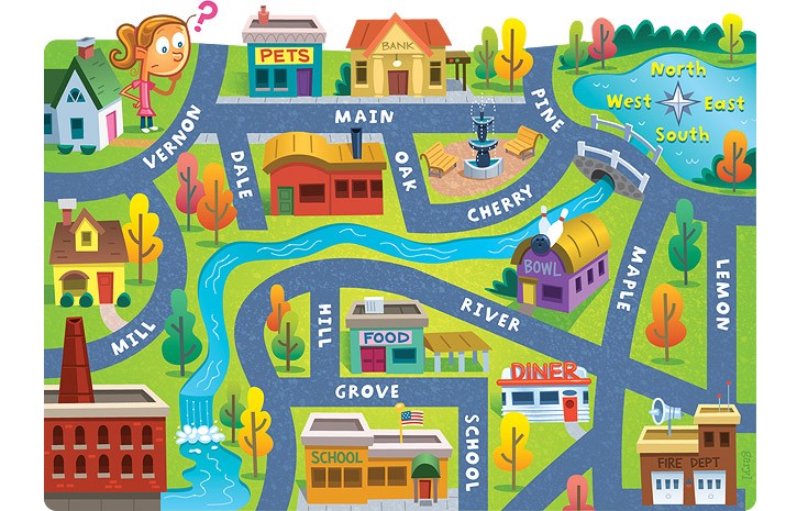
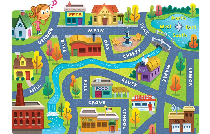
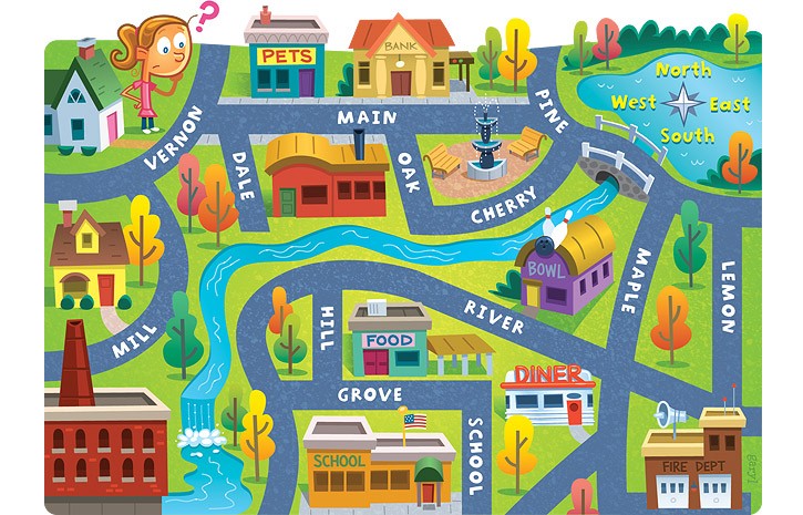
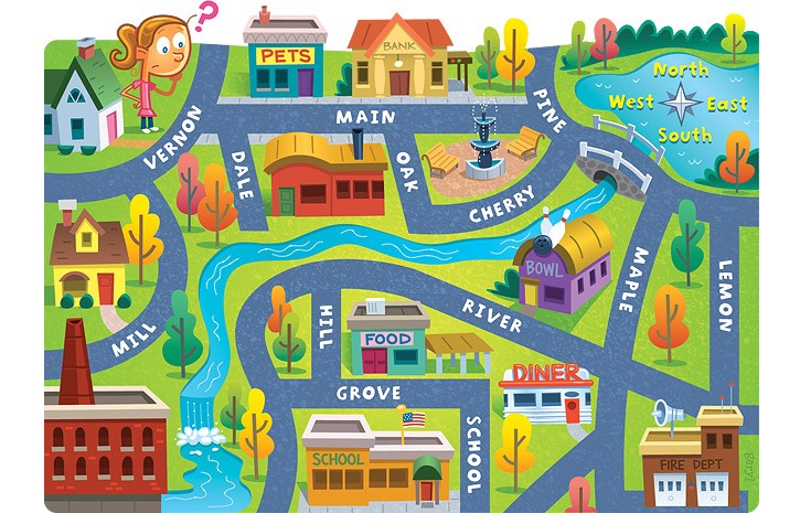
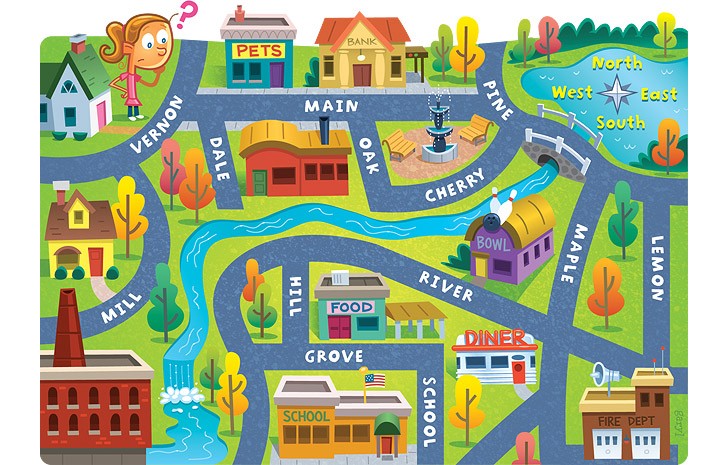
The bank is on what street?
a)
Main
b)
Maple
c)
Lemon
d)
River
17.
The school is ____ of the pet store.
a)
North
b)
South
c)
East
d)
West
18.
Lemon street runs _____________.
a)
East and West
b)
North and South
c)
South and West
d)
North and East
19.
What are the four cardinal direction?
a)
North, South, Windy, Sunny
b)
Never Eat Slimy Worms
c)
North, South, East, West
d)
South Never Eat West
20.
The fire dept. is ______ of the school.
a)
South
b)
East
c)
North
d)
West
21.
The bank is ____ of the pet store.
a)
East
b)
North
c)
West
d)
South
22.

What is the name of the line that divides the earth into eastern & western hemispheres?

a)

equator

b)

latitude

c)

prime meridian

d)

longitude

23.

This tells you what the map is showing

a)

Key

b)

Title

c)

Compass rose

d)

Scale bar

24.

What is the line that goes horizontal through the middle of the Earth, and separates the North and South Hemisphere?

a)

Prime Meridian

b)

Equator

c)

East and West

d)

North and South

25.

What tool on a map helps us find directions?

a)

Title

b)

Map Key

c)

Compass Rose

d)

Equator

26.

A very large body of water

a)

continent

b)

symbol

c)

hemisphere

d)

ocean

27.

Small drawings on a map that stand for something.

a)

intermediate directions

b)

prime meridian

c)

symbols

d)

hemisphere

28.

Tells what each symbol of a map means.

a)

map key

b)

hemisphere

c)

continent

d)

symbol

29.

North, South, East, West

a)

cardinal directions

b)

intermediate directions

30.

A very large body of land.

a)

ocean

b)

continent

c)

hemisphere

d)

map title

31.

Half of the earth

a)

Sphere

b)

continent

c)

hemisphere

d)

symbol

32.

Tells you what part of the world is shown on the map.

a)

Map title

b)

equator

c)

continent

d)

cardinal directions

33.

A body of land surrounded by water on all sides.

a)

Island

b)

Mesa

c)

Peninsula

d)

Mountain

34.

A vent or crack in the Earth's surface through which molten rock escapes.

a)

Valley

b)

Island

c)

Volcano

d)

Mountain