
 Worksheets
Exam 2 Review
Total questions: 48
Worksheet time: 16mins
Name
Class
Date
1.

What is the name of this line at 0 degrees latitude?
a)
Prime Meridian
b)
Equator
c)
North Pole
d)
South Pole
2.

What is the name of the line at zero degrees longitude?
a)
Equator
b)
Prime Meridian
c)
North Pole
d)
South Pole
3.

a)
The map show the lines of longitude.
b)
The map shows the lines of latitude.
4.

a)
The map shows lines of longitude.
b)
The map shows lines of latitude.
5.
What shape is the planet Earth?
a)
hemisphere
b)
circle
c)
sphere
d)
hemicube
6.
Which Hemisphere are both North America and South America found in?
a)
Western Hemisphere
b)
Eastern Hemisphere
c)
Southern Hemisphere
d)
Northern Hemisphere
7.
Latitude and Longitude are measured in______.
a)
kilometers
b)
degrees
c)
miles
d)
hours
8.
A Hemisphere is half of a sphere.
a)
True
b)
False
9.
Lines of ___________ run from the North Pole to the South Pole.
a)
latitude
b)
longitude
c)
equator
10.
Lines of longitude run north and south.
a)
True
b)
False
11.
Lines of latitude run east and west.
a)
True
b)
False
12.
the Rocky Mountains of North America
a)
political
b)
physical
13.
Africa's Sahara Desert
a)
political
b)
physical
14.
the regions of Europe, Russia, and Asia
a)
political
b)
physical
15.
the six states of Australia
a)
political
b)
physical
16.
the Panama Canal
a)
political
b)
physical
17.
U.S. capital in Washington, D.C
a)
political
b)
physical
18.
Mountains
a)
Political
b)
Physical
19.
Borders
a)
Physical
b)
Political
20.
Rivers
a)
Physical
b)
Political
21.
Major Cities
a)
Political
b)
Physical
22.
Countries
a)
Political
b)
Physical
23.
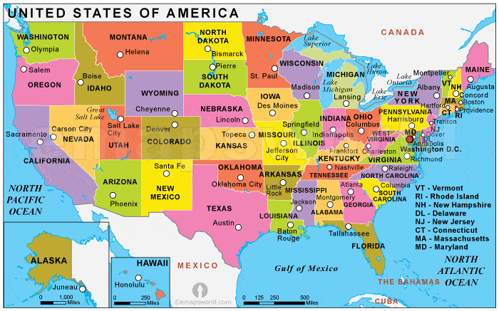
What type of Map is this
a)
Political
b)
Physical
24.
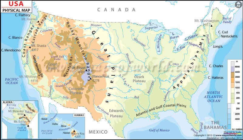
What type of Map is this
a)
Political
b)
Physical
25.
The word hydro- means _______________________________.
a)
wind
b)
water
26.
The Hoover Dam is an example of a hydroelectric power plant.
a)
True
b)
False
27.
A hydroelectric power plant generates electricity by using the energy of which of the following?
a)
Blowing wind
b)
Organic material
c)
Moving water
d)
Earth’s core
28.
All of the following are considered alternative energy sources EXCEPT –
a)
Wind
b)
Coal
c)
Biofuel
d)
Solar
29.
Which of the following is a renewable resource?
a)
Oil
b)
Coal
c)
Crops
d)
Natural Gas
30.
Fossil fuels include coal, oil and natural gas. Fossil fuels are classified as nonrenewable because they —
a)
Take many, many years to be replaced
b)
require expensive equipment
c)
Can be found all over Earth's surface
d)
Provide much of the energy we use
31.
Which of the following is a nonrenewable resource?
a)
Water
b)
Oxygen
c)
Wood
d)
Oil
32.

Coal is a __________ energy resource.
a)
Renewable
b)
Nonrenewable
33.

Solar Power is a __________ energy resource.
a)
Renewable
b)
Nonrenewable
34.

Oil is a __________ energy resource.
a)
Renewable
b)
Nonrenewable
35.

Wind is a __________ energy resource.
a)
Renewable
b)
Nonrenewable
36.

What continent is this?
a)
Europe
b)
Africa
c)
North America
d)
South America
37.
A map that shows the different countries and their borders is a
a)
road map
b)
political map
c)
physical map
38.
A map that shows geographical terms, such as mountains, desert and forest is called a
a)
political map
b)
physical map
c)
highway map
39.
Which two physical features do the United States and Canada share?
a)
Appalachian Mts. and Mississippi River
b)
St. Lawrence River and Rocky Mts.
c)
Mississippi River and the Great Lakes
d)
Rocky Mountains and the Great Lakes
40.

Alaska is a _________state
a)
pacific
b)
northeast
c)
south east
d)
non-contiguous
41.
A flat area or land.
a)
Ocean
b)
Island
c)
Peninsula
d)
Plain
42.

What land form is this?
a)
valley
b)
plain
c)
volcano
d)
canyon
43.

What land form is this?
a)
valley
b)
canyon
c)
plain
d)
mountain
44.
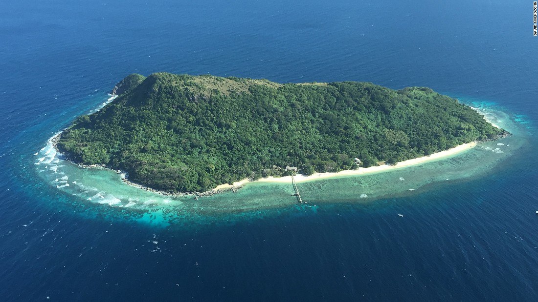
What land form is this?
a)
island
b)
valley
c)
plain
d)
mountain
45.

What land form is this?
a)
valley
b)
plain
c)
volcano
d)
mountain
46.
True or False. Scientist classify climates according to temperature and precipitation.
a)
True
b)
False
47.
Where would I find humid equatorial climate?
a)
along the poles
b)
at 90N and 90S
c)
close to Japan
d)
along the equator
48.

What is this landform?
a)
Desert
b)
Mountain
c)
Valley
d)
Plateau
100 %

