
 Worksheets
Water in the World
Total questions: 20
Worksheet time: 11mins
Why do most Australians live along the coast? (you will select more than one answer)
mild temperatures
access to trade with New Zealand
plentiful rainfall
excellent farmland
Where do most Australians live?
North East coast
South East coast
South West coast
North coast
Most of Australia is what type of climate zone?
Uniform
Arid
Temperate
Tropical

What is the water cycle?
The 3 forms of water
The movement of water on, above, or below the surface of the Earth
When water melts after being in a frozen state
When clouds form in the sky

Which best explains why runoff is important?
It returns water to other locations on Earth
It increases the chance of flooding
It makes evaporation occur faster
It increases condensation

Snow, sleet, hail, and rain are all examples of ________________.
evaporation
condensation
accumulation
precipitation

What is it called when plants give off water vapor as a waste product?
condensation
evaporation
sublimation
transpiration
How much of the Earth's fresh water in drinkable?
1%
11%
2%
99%
Which industry uses the most water in Australia?
Advertising
Agriculture
Accounting
Aeronautical
What are 2 positive ways the Brisbane River helps connect people? (select all that are correct)
People can use the river for leisure activities
People can meet in Southbank to have meals, enjoy art and enjoy the views.
People can't cross from one side to the other if there's no bridge
People close to the river are at risk of experiencing floods
Which of these was NOT a reason for the 2011 floods in Brisbane
Australia had had the wettest 6 months ever leading up to the floods
December 2010 had been the wettest December on record for Queensland
Wivenhoe Dam was 190% beyond capacity so it was opened to release the pressure of the water on the dam walls
There was a huge thunderstorm in Melbourne which caused lots of water to flood the Yarra River
A climate graph shows information about which two things
Climate zones & rainfall
Rainfall & temperature
Temperature & humidity
Rainfall & humidity
What is an example of an atmospheric hazard?
Flood
Drought
Thunderstorm
Avalanche
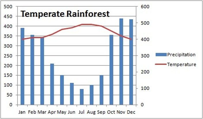
If this rainforest was in northern Queensland, which 'season' sees the most rainfall?
Summer
Autumn
Winter
Spring
If this rainforest was in northern Queensland, which 'season' is the coolest?
Summer
Autumn
Winter
Spring
What is the name of the large body of ground water underneath much of Australia's east?
The Great Big Waterhole
The Great Wet Lake
The Great Underground Watery Place
The Great Artesian Basin
What is NOT an example of a hydrological hazard
Tsunami
Thunderstorm
Flood
Drought
A city that is closer to the equator will have what type of weather?
Cooler & windier
Warmer & windier
Warmer & wetter
Cooler & wetter
What are some ways the The Ganges River is important to Hindus? (select all that are correct)
Hindus believe it is one of their Gods
Hindus believe that it has healing powers
People come together at its banks each morning to pay homage to the river
Hindus have swimming competitions in the river each Christmas

