
NEW
Font size
 Worksheets
S1 Unit 1: Georgia Regions, Physical, Transportation
Total questions: 28
Worksheet time: 12mins
1.) In which two hemispheres is Georgia located?
Northern and Western
Southern and Eastern
Northern and Eastern
Southern and Western
Rolling hills are to the Piedmont region as Georgia’s highest mountains are to the _____ region.
Ridge and Valley
Blue Ridge
Appalachian Plateau
Piedmont
The high peaks in this region provide precipitation for the rest of the state as well as the creation of many river systems in Georgia.
Coastal Plain
Appalachian Plateau
Blue Ridge
Piedmont
Within what region of the United States would you locate Georgia?
Midwest
Pacific Northwest
Southeast
Northeast
Which region is known for red clay soil, a large population, and its location near the Fall Line?
Ridge and Valley
Coastal Plain
Blue Ridge
Piedmont
Georgia is located on what continent?
United States
South America
North America
Atlanta
1.) Michael is visiting tourist locations in states that border Georgia. Which of the following locations would he NOT visit?
Talladega Raceway in Alabama
The Grand Ole Opry in Nashville, Tennessee
The University of Mississippi in Oxford, Mississippi
Hilton Head Beach in South Carolina
This physical feature of Georgia extends through three regions of Georgia, and crosses from our nation into Canada.
The Rocky Mountains
The Appalachian Mountains
The Cascade Mountains
Mt. St. Helen
1.) Pretend it is 1820 and electricity does not yet exist. You need to build a small factory that will use water to generate hydropower. At which physical feature are you most likely to construct your factory?
Okefenokee Swamp
Warm Springs
Coastal Plain
Fall Line
Why is the Okefenokee Swamp unique?
It is the only swamp in North America.
It is the largest area of land in the world NOT inhabited by humans.
It is the only wetland home to alligators in the southeast United States.
It is the largest freshwater swamp in North America.
Which of the following best describes the economic importance of the Savannah River?
Native Americans and de Soto both used the river for transportation and exploration.
Forms the border between Georgia and South Carolina.
Provides drinking water for Atlanta.
International companies use the deepwater port at Savannah to transport goods overseas.

1.) If you traveled in a STRAIGHT LINE from Atlanta to Brunswick, how could you expect the geography to change?
The land would become more mountainous and dry as you reach the coast.
The flat land would become more hilly as you travel south across the Fall Line.
Traveling southward, you would have to first cross over steep ridges before reaching the flat, dry land of the Coastal Plain.
You would leave the hilly land around Atlanta and would reach flatter terrain as you move south toward the coast.

If you traveled in a STRAIGHT LINE from Clayton to Dalton, how could you expect the geography to change?
The land in Clayton would be hilly, and the land in Dalton would be mountainous.
You would leave the mountains around Clayton and reach smaller ridges as you moved toward Dalton.
You would have to travel through a long, deep valley before reaching the large wetland near Dalton.
The land in Clayton would be more flat and dry than the ridges and valleys near Dalton

Which geographic region of Georgia is in the top left had corner of the state on the map above?
Blue Ridge
Ridge and Valley
Piedmont
Coastal Plain
Appalachian Plateau
Which geographic region of Georgia is in the top center of the state between two other regions on the map above?
Blue Ridge
Ridge and Valley
Piedmont
Coastal Plain
Appalachian Plateau
Which geographic region of Georgia is in the top right of the state on the map above?
Blue Ridge
Ridge and Valley
Piedmont
Coastal Plain
Appalachian Plateau
Which geographic region of Georgia is in the center of the state on the map above?
Blue Ridge
Ridge and Valley
Piedmont
Coastal Plain
Appalachian Plateau
Which geographic region of Georgia is in the bottom of the state on the map above?
Blue Ridge
Ridge and Valley
Piedmont
Coastal Plain
Appalachian Plateau
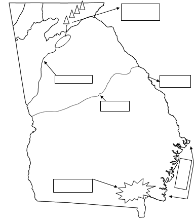
Which physical feature of Georgia is on the coast of Georgia?
Barrier Islands
Appalachian Mountains
Fall Line
Okefenokee Swamp
Which physical feature of Georgia is located near the bottom of the state but awsy form the coast?
Barrier Islands
Appalachian Mountains
Fall Line
Okefenokee Swamp
Which physical feature of Georgia is runs across the center of the state?
Barrier Islands
Appalachian Mountains
Fall Line
Okefenokee Swamp
Which physical feature of Georgia is located mainly in the northern part of the state?
Appalachian Mountains
Barrier Islands
Fall Line
Okefenokee Swamp
Which physical feature of Georgia runs along the right hand side of the state?
Savannah River
Barrier Islands
Fall Line
Okefenokee Swamp
Which physical feature of Georgia runs through Atlanta heading west then runs partly along the left hand side of the state?
Chattahoochee River
Barrier Islands
Fall Line
Okefenokee Swamp
Why did cities like Atlanta or Savannah have high populations density?
Atlanta' population has decreased
Savannah has a deep water port, Atlanta has an International Airport, both have major interstate systems
Atlanta has a deep water port and Savannah has an International Airport
Both have deep water ports, international Airports and major interstates,
The MAIN purpose of earning an income
To buy unnecessary items
To be able to donate to charity
So you can avoid using credit cards
Provides funds to cover expenses and save for the future
Benefits of using a credit card include
Make large purchases when needed and build a credit history
Accumulate debt and damage your credit history
Avoid paying interest fees
How do large companies in Atlanta help encourage entrepreneurship in the area?
By providing direct ownership to local residents
They create a demand for goods and services from other businesses
They offer financial support to new start up companies

