
NEW
Font size
S
M
L
XL
 Worksheets
map skills
Total questions: 42
Worksheet time: 3hrs 33mins
Name
Class
Date
1.

What hemisphere do you live in?
a)
Canadian
b)
Northern
c)
Southern
d)
Mexican
2.
The four main points of the compass North, South, East, and West.
a)
Compass Rose
b)
Cardinal Directions
c)
Intermediate Directions
d)
Map Scale
3.
North, South, East and West are referred to as the _________directions.
a)
raven
b)
bluejay
c)
cardinal
d)
robin
4.
Which direction normally is pointing to the top of the page on a map?
a)
North
b)
South
c)
East
d)
West
5.
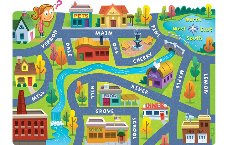
The bank is on what street?
a)
Main
b)
Maple
c)
Lemon
d)
River
6.
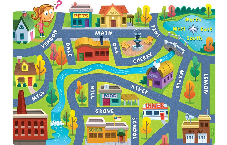
The school is ____ of the pet store.
a)
North
b)
South
c)
East
d)
West
7.
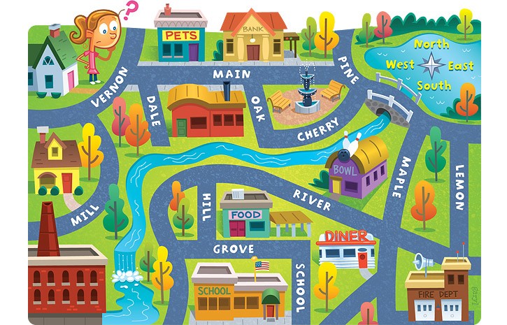
Lemon street runs _____________.
a)
East and West
b)
North and South
c)
South and West
d)
North and East
8.
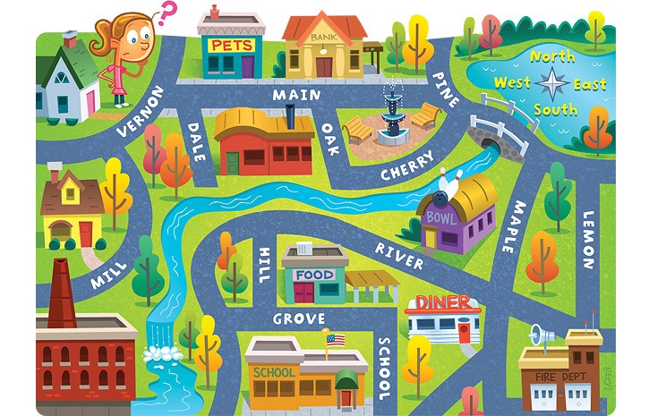
The fire dept. is ______ of the school.
a)
South
b)
East
c)
North
d)
West
9.
The 0 degree latitude line that divides the Northern and Southern Hemispheres.
a)
Prime Meridian
b)
time zone
c)
equator
d)
International Dateline
10.
Where would you find the symbol that indicates which city on the map is the capital city?
a)
map scale
b)
map legend
c)
map elevation
d)
map title
11.
NE, SE, NW, SW are these type of directions.
a)
cardinal
b)
intermediate
c)
main
d)
subterrain
12.
What map feature can help you determine the approximate distance between two locations?
a)
map scale
b)
key
c)
title
d)
distance calculator
13.

What are these lines known as ?
a)
latitude
b)
relative location
c)
longitude
d)
absolute location
14.

What are these lines known as?
a)
latitude
b)
longitude
c)
relative location
d)
absolute location
15.

What is this object known as?
a)
map symbol
b)
map key
c)
map scale
d)
compass rose
16.
Latitude and Longitude are measured in ________.
a)
inches
b)
feet
c)
degrees
d)
grams
17.
Latitude lines run
a)
East to West
b)
North to South
18.
This line measures 0 degrees longitude:
a)
Equator
b)
International Date Line
c)
Meridians
d)
Prime Meridian
19.
The 0 degree line of latitude is the ___________.
a)
Equator
b)
Prime Meridian
c)
International Date Line
d)
Contour line
20.

What direction is indicated by the number 5?
a)
northeast
b)
northwest
c)
southeast
d)
southwest
21.
What is a map scale?
a)
a tool to measure distance
b)
a tool to tell direction
c)
a tool to start a fire
d)
a tool to build a house
22.
Explains what the symbols on a map represent
a)
Bar Scale
b)
Map Key/Legend
c)
Compass Rose
d)
Parallels
23.
An imaginary line that divides the eastern and western hemispheres?
a)
equator
b)
longitude
c)
latitude
d)
prime meridian
24.
The equator divides what two hemispheres?
a)
East and West
b)
North and South
25.

All lines of latitude meet at both the north and south poles.
a)
True
b)
False
26.
All lines of longitude meet at both the north and south poles.
a)
True
b)
False
27.
If you're having trouble figuring out what the symbols on a map represent, where would you look?
a)
The back of the map.
b)
The title of the map
c)
The map legend
d)
The compass rose
28.

On the following map, what do the grey triangles represent?
a)
Sources of fuel
b)
Gold mines
c)
Areas where precious gems can be found
d)
Areas where nonmetals can be found
29.
The prime meridian and equator divide the Earth into halves called ____________________.
a)
Atlas
b)
Hemispheres
c)
Scales
d)
Cardinal
30.

A map ____________________ shows the relationship between distance on the map and distance on Earth.
a)
Scale
b)
Equator
c)
Cardinal
d)
Grid
31.

Which river is located at #5?
a)
Hudson
b)
Rio Grande
c)
Mississppi
d)
Ohio
32.

Which river is numbered 2 on this map?
a)
Nile
b)
Colorado
c)
Ohio
d)
Rio Grande
33.

Which river is numbered 1 on this map?
a)
Rio Grande
b)
Colorado
c)
Hudson
d)
Mississippi
34.

Which river is numbered 3 on this map?
a)
Mississippi
b)
Hudon
c)
Chattahoochee
d)
Ohio
35.

What mountain range is located at number 3?
a)
Rocky Mountains
b)
Atlas Mountain
c)
Appalachian Mountains
d)
Andes Mountains
36.
Which mountain range is in the eastern region of the United States?
a)
Rocky Mountains
b)
Appalachian Mountains
c)
Andes Mountains
d)
Himalayas Mountains
37.

What river is located at number 4?
a)
Hudson River
b)
Mississippi River
c)
Ohio River
d)
Colorado Rivew
38.

What mountain range is located at number 7?
a)
Atlas Mountains
b)
Appalachian Mountains
c)
Rocky Mountains
d)
Himalayas Mountains
39.
Which river flows through six states before emptying into the Mississippi River?
a)
Ohio River
b)
Hudson River
c)
Rio Grande
d)
Colorado River
40.

What mountain range is #1?
a)
Hudson Mountains
b)
Rocky Mountains
c)
Appalachian Mountains
d)
Great Smokey Mountains
41.

That mountain range is #4?
a)
Rocky Mountains
b)
Chattahoochee River
c)
Appalachian Mountains
d)
Newnan, GA
42.

Which mountain range is in north Georgia
a)
Chattahoochee River
b)
Rocky Mountains
c)
Pike's Peak
d)
Appalachian Mountains
Reset

