wayground logo

Free Printable Worksheets

Font size

S
M
L
XL
Worksheets

CH. 1 Review

Total questions: 54

Worksheet time: 28mins

Name
Class
Date
1.
What helps a geographer find distance on a map?
a)
Key
b)
Legend
c)
Scale
d)
Map Grid
2.
What are the Degrees for the International Date Line?
a)
0 Degrees Latitude
b)
0 Degrees Longitude
c)
180 Degrees Latitude
d)
180 Degrees Longitude
3.
What is this an example of: 500 S Capitol Ave, Indianapolis, IN 46225?
a)
Absolute Location
b)
Relative Location
4.
What are the Degrees of the Equator?
a)
0 Degrees Latitude
b)
0 Degrees Longitude
c)
180 Degrees Latitude
d)
180 Degrees Longitude
5.
Brazil is located in which continent?
a)
Asia
b)
Australia
c)
South America
d)
Antarctica
6.
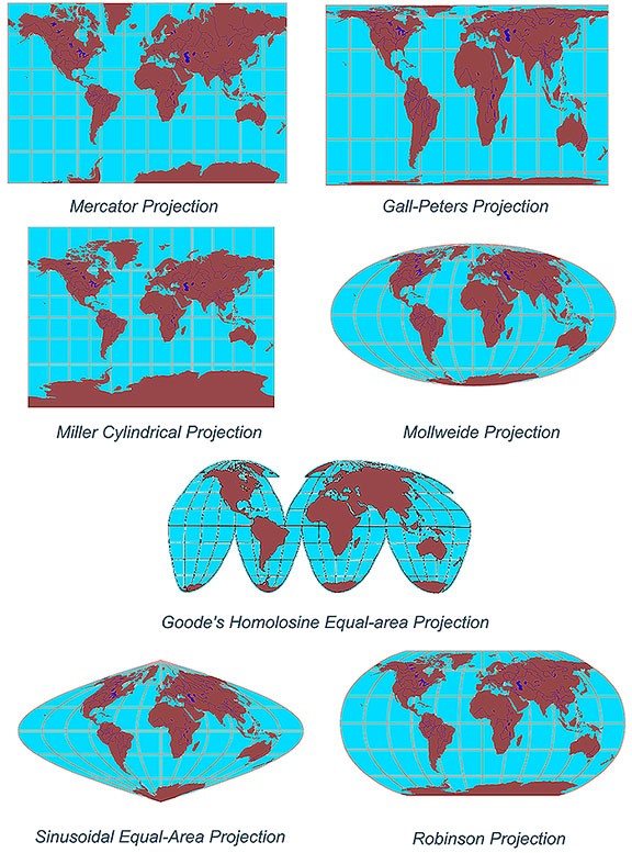
Which GeoTerm explains this image?
a)
Absolute Location
b)
Relative Location
c)
Distortion
d)
Map Projection
7.
Which continent is the largest?
a)
Africa
b)
Asia
c)
Australia
d)
North America
8.
Changing a map from 3D to 2D is __________.
a)
Absolute Location
b)
Relative Location
c)
Distortion
d)
Map Projection
9.
All 2D, flat maps, are distorted.
a)
True
b)
False
10.
Which map projection provides the most realistic depiction of the globe? 
a)
Mercator
b)
Robinson 
c)
Miller 
d)
Gall-Peters
11.
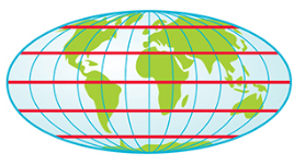
The Red lines are showing what? 
a)
Longitude
b)
Latitude
c)
Prime Meridians
d)
Tropics
12.
What word best connects to "The science of making maps"? 
a)
Geography
b)
Cartography
c)
Projectionist
d)
Diagramist
13.
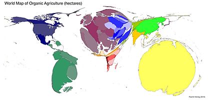
What type of map is this? 
a)
Cloropleth
b)
Dot Distribution
c)
Cartogram
d)
Physical
14.
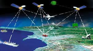
What technology is being shown in the picture? 
a)
GIS
b)
GPS
c)
CRI
d)
FAQ
15.
What type of map is being shown? 
a)
Political
b)
Mental Map
c)
Distrotion
d)
Cartogram
16.

Roughly where is the international dateline?

a)

West of Ireland

b)

Through The Middle of the Pacific Ocean

c)

East of Japan

d)

Just off the Coast of California

17.
What is the Direct Greek translation of Geography? 
a)
Earth Study 
b)
Planet Study
c)
Places Study
d)
Life Study 
18.
An example of Physical Geography is ...
a)
People
b)
Planets
c)
Rivers
d)
Physical Education
19.
The study of how people interact with the Earth is ...
a)
Human Geology
b)
Human Geography
c)
Human Biology
d)
Human Topography
20.
Why do we study Geography?
a)
To learn about locations
b)
To learn about vacations
c)
To learn about spacecraft
d)
To learn about rocks
21.
Which one of these is NOT a type of map?
a)
Mercator Projection
b)
Peters Projection
c)
Robinson Projection
d)
Lively Projection
22.
Which map is good for navigation?
a)
Mercator Projection
b)
Peters Projection
c)
Robinson Projection
d)
Interrupted Projection
23.
What does GPS stand for?
a)
Global Plotting System
b)
Global Putting System
c)
Global Positioning System
d)
Gabby Party Sisters
24.
What does GIS stand for?
a)
Geographic Information System
b)
Geographic Intelligence System
c)
Geographic Iphone System
d)
Geeky Insult System
25.
Scale is…                                     
a)
the system used by geographers to transfer locations  from a globe to a map
b)
the extent of spread of a phenomenon over a given area
c)
 the difference in elevation between two points in an area
d)
 the relationship between the length of an object on a map and that feature on the landscape
26.
What geographic tool is represented in the picture above?
a)
Grid
b)
Scale
c)
Projection
d)
Legend (Key)
27.

Which continent is shaded red?

a)

Europe

b)

Asia

c)

Australia

d)

Africa

28.

Which continent is shaded orange?

a)

Europe

b)

Asia

c)

Australia

d)

Africa

29.
Which continent is shaded purple?
a)
Europe
b)
Asia
c)
Australia
d)
Africa
30.
The physical qualities of the original location for a city is referred to as the
a)
site
b)
situation
c)
relative location
d)
absolute location
31.
Geographers group like things together into regions in order to make them easier to study.  What type of region would a corn field be?
a)
Perceptual
b)
Formal
c)
Functional
d)
Vernacular
32.
Measuring the distance people are willing to travel to shop at a store would be creating what type of region for that store?
a)
Formal
b)
Perceptual
c)
Functional
d)
Uniform
33.
Billy thinks that in the south, everyone eats grits, eats fried chicken and watches football.  He would be creating what type of region of the south with these ideas?
a)
Formal
b)
Functional
c)
Perceptual
d)
Uniform
34.
Which of the following divides Earth into Eastern and Western Hemispheres?
a)
Prime Meridian
b)
Hemisphere Line
c)
Equator
d)
Tropic of Capricorn
35.
What is spatial perspective?
a)
Changes across space
b)
How different cultures spread
c)
The spreading of disease
d)
The continuity amongst the world
36.
Activity spaces are....
a)
Mental maps of the places where we travel routinely in our rounds of daily activity.
b)
Generalized maps of how to get to a place.
c)
Familiarity within our neighborhood, city, county, and country.
d)
Relative location of our house.
37.
Which of the following do geographers use to compare a variety of spatial data by creating digitized representations of the environment by combining layers of spatial data, and creating maps in which patterns and processes are superimposed?
a)
GPS
b)
GIS
c)
Scale
d)
Mental Maps
38.
Relative location is....
a)
location of a place in relation to other human and physical features.
b)
Precise coordinates of a place.
c)
General trends we see of a given phenomenon.
d)
Digitized representations of the environment.
39.
The French-speaking region of Europe is what type of region?
a)
Formal
b)
Functional
c)
Perceptual 
d)
Rescale
40.
The choices that a society makes depend on what its members need and on what technology is available to them this is called...
a)
environmental determinism
b)
Possibilism 
c)
political ecology
d)
cultural ecology
41.
This theory explains that Europe as "superior" to the rest of the world because of the climate and location of the region is called...
a)
Environmental Determinism
b)
Possibilism
c)
Time distance decay
d)
Formal Region
42.

A geographical term which describes the effect of distance on cultural or spatial interactions is called...

a)

Distance Decay

b)

Spatial Analysis

c)

Time space compression

d)

Possibilism

43.

Which of the following projections have all parallels of latitude the same length as the equator and shows distortion in the poles.

a)

Robinson

b)

Mercator

c)

Galls Peters

d)

Waterman Butterfly

44.

Which of the following is NOT an example of a thematic map?

a)

Political Map

b)

Dot Symbol Map

c)

Cartogram

d)

Isoline Map

45.

Which of the following is NOT an example of a reference map?

a)

Isoline Map

b)

Political Map

c)

Physical Map

d)

All of the answers are an example of a reference map

46.

Which concept is illustrated here?

a)

Scale

b)

Region

c)

Spatial Analysis

d)

Map Distortion

47.
The process of the spread of an idea and/or dissemination of an innovation from its source area to other cultures, is the process of cultural: 
a)
diffusion
b)
simultaion
c)
adaptation
d)
movement
48.
This image demonstrates
a)
Regions
b)
Stimulus Diffusion
c)
Globalization
d)
None of the above
49.
The map projection with the greatest amount of distortion, although visually appealing because of its nice, straight lines, is called _____.
a)
Mercator
b)
Gall-Peters
c)
Azimuthal
d)
Homolosine
50.
The science of making maps
a)
cartography
b)
cartographer
c)
distortion
51.
The word "geography" literally means
a)
the study of space.
b)
Earth study.
c)
people and nature.
d)
Earth writing.
e)
human ground
52.

Lines called _____________ and ____________ combine to form the "global grid," and are used to identify absolute location. CHOOSE TWO!

a)

parallels

b)

meridians

c)

coordinates

d)

topographic

53.

The geographic study of human-environmental relationships.

a)

cultural ecology

b)

ecological culture

54.

These maps show the importance of changing _____________ in understanding something (like cancer rates in the US)

a)

regions

b)

scale

c)

site