wayground logo

Free Printable Worksheets

NEW

Font size

S
M
L
XL
Worksheets

Map skills review

Total questions: 66

Worksheet time: 2hrs 3mins

Name
Class
Date
1.

high flat land

a)

plateau

b)

lake

c)

plain

d)

valley

2.

Lines of longitude run_______

a)

East and West

b)

South and West

c)

North and South

d)

North and East

3.

Lines of latitude run_______

a)

East and West

b)

South and West

c)

North and South

d)

North and East

4.

Which direction is stared?

a)

northeast

b)

southwest

c)

westsouth

d)

eastwest

5.

_____divides places on Earth into countries, states,cities, and other units

a)

Product Map

b)

Political Map

c)

Climate Map

d)

Road Map

6.

_____shows what the surface of the Earth looks like

a)

Product Map

b)

Political Map

c)

Climate Map

d)

Physical Map

7.

___shows info about the climate of an area

a)

Physical Map

b)

Road Map

c)

Climate Map

d)

Product Map

8.

____shows what types of things are raised, grown, or found in a place

a)

Physical Map

b)

Road Map

c)

Climate Map

d)

Product Map

9.

What are the coordinates of letter A?

a)

50 N 120W

b)

40N 110W

c)

50 N 110 W

d)

45 N 110 W

10.
How many oceans does Earth have? 
a)
2
b)
3
c)
4
d)
5
11.
Name Continent C!
a)
Antarctica
b)
Europe
c)
Asia
d)
North America
12.
Continent G is ________.
a)
Asia
b)
Antarctica
c)
North America
d)
Europe
13.

What direction is number 5?

a)

northeast

b)

northwest

c)

southeast

d)

southwest

14.

What is latitude?

a)

lines that go east and west

b)

lines that go north and south

15.

What is longitude?

a)

lines that go east and west

b)

lines that go north and south

16.
What tells you the directions on a map?
a)
legend 
b)
compass rose 
c)
scale 
17.
What tells you what the symbols on the map stand for? 
a)
compass rose 
b)
legend 
c)
scale 
18.
What is this?
a)
key
b)
title
c)
compass rose
d)
star
19.
What does the red line in the picture show?
a)
Prime Meridian
b)
Equator
c)
continents
d)
countries
20.
The Prime Meridian splits the world into
a)
Norther and Southern Hemispheres
b)
Eastern and Western Hemispheres
21.
Which state borders Ohio to the West?
a)
California
b)
Indiana
c)
Pennsylvania
d)
Michigan
22.
What hemisphere do you live in?
a)
Canadian
b)
Northern
c)
Southern
d)
Mexican
23.
What Continent do you live on?
a)
South America
b)
Europe
c)
North America
d)
Australia
24.
Identify this map
a)
Road Map
b)
Physical Map
c)
Political Map
d)
Climate Map
25.
Identify this map
a)
Road map
b)
Climate Map
c)
Physical Map
26.

Name Continent D!

a)

Antarctica

b)

Europe

c)

Asia

d)

North America

27.
This line measures 0 degrees longitude:
a)
Equator
b)
International Date Line
c)
Meridians
d)
Prime Meridian
28.
The 0 degree line of latitude is the ___________.
a)
Equator
b)
Prime Meridian
c)
International Date Line
d)
Contour line
29.
Which is the best way to find the exact location of any place on a map?
a)
Using latitude & longitude
b)
Use only latitude
c)
Asking a friend for help
d)
Use only longitude
30.
Which is the smallest continent?
a)
United Kingdom
b)
South America
c)
Europe
d)
Australia
31.
What is north of the picnic area?
a)
woods
b)
soccer field
c)
swimming pool
d)
playground
32.
What is west of the ice cream stand?
a)
playground
b)
swimming pool
c)
picnic area
d)
woods
33.
Which city grows tea near it
a)
Beijing
b)
Shanghai
c)
Wuhan
d)
Hong Kong
34.
What direction would you travel in to get from Perth to Sydney
a)
North
b)
East
c)
South 
d)
West
35.
What country is NORTH of the United States of America?
a)
Mexico
b)
Canada
36.
What continent is this?
a)
Australia
b)
South America
c)
Mexico
d)
Virginia
37.
What continent is this?
a)
Asia
b)
North America
c)
Africa
38.
What continent is this?
a)
North America
b)
South America
c)
Africa
d)
Europe
39.
Name the part of the map labeled with "A."
a)
Key
b)
Title
c)
Compass Rose
40.
What does blue represent on a map?
a)
railroads
b)
airport
c)
hospital
d)
bodies of water
41.
The study of human and nonhuman features of the Earth.
a)
Cardinal Directions
b)
Geography
c)
Latitude
d)
Region
42.
North, South, East, and West are called:
a)
Intermediate Directions
b)
Cardinal Directions
c)
Longitude
d)
Meridians
43.
Earth is a round-shaped body or a :
a)
Sphere
b)
Hemisphere
c)
Round
d)
Equator
44.
The distance north or south of the equator is measured using:
a)
Prime Meridian
b)
Longitude
c)
Latitude
d)
Degrees
45.
The unit that latitude and longitude is measured in:
a)
Equator
b)
Prime Meridian
c)
Degrees
d)
Longitude
46.
Each half of the earth is called:
a)
Sphere
b)
Hemisphere
c)
Globe
d)
Scale
47.
A map that shows physical or natural, features.
a)
Political Map
b)
Projection
c)
Globe
d)
Physical Map
48.

The purpose of a map legend (or key) is:

a)

To explain the history of the map

b)

To figure out the distance from one place to another

c)

To identify the meaning of symbols on the map

d)

Figure out which direction to move

49.

The purpose of a map legend (or key) is:

a)

To explain the history of the map

b)

To figure out the distance from one place to another

c)

To identify the meaning of symbols on the map

d)

Figure out which direction to move

50.
Political Maps show: 
a)
The features people have created, such as cities, states, provinces, territories, and countries. 
b)
Landforms and bodies of water found in particular areas
c)
Certain information (climate, population, languages, etc.) about a place or region 
d)
Directions to making sense of politics
51.
Earth is divided into seven landmasses known as ______________________.
a)
Hemispheres
b)
Countries
c)
Continents
d)
Sandboxes
52.

Physical Map

a)
b)
c)
d)
53.

Political map

a)
b)
c)
d)
54.
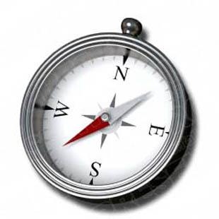
An instrument used to tell direction is called a _______________________ (shown in the picture)
a)
direction finder
b)
guide
c)
compass
d)
gps
55.

According to the map, which state is west of Nevada?

a)

Utah

b)

California

c)

Idaho

d)

Arizona

56.

the exact location of a place. using latitude and longitude

a)

relative location

b)

absolute location

c)

scaled location

d)

location of place

57.

where a place is located in relation to another place

a)

relative location

b)

absolute location

c)

scaled location

d)

location of place

58.
Tells the subject of a map
a)
map key
b)
map scale
c)
map title
59.
NE, SE, NW, SW are these type of directions.
a)
cardinal
b)
intermediate
c)
main
d)
subterrain
60.
Longitude and Latitude lines intersect to form the _________.
a)
graph paper
b)
global grid
c)
crisscross applesauce
d)
map scale
61.

Andrew is traveling to the Rocky Mountains. He stops at a convenient store and purchases a map. He does not understand all the symbols that are on the map. What does he need to look for on the map to help him better understand it?

a)

symbol

b)

treasure

c)

legend

d)

graph

62.

Kam is drawing a map for his 4th grade history project. He states that the Earth has 5 major oceans, and they are called the Pacific, Arctic, Southern, Indian, and Northern oceans. Which of the following is not one of Earth's oceans?

a)

Pacific

b)

Arctic

c)

Southern

d)

Northern

63.

Our World is made up of seven continents. The content we live on is North America. Which continent is furthest south?

a)

Australia

b)

Antarctica

c)

Asia

d)

South America

64.

a 3D spherical representation of the earth

a)

globe

b)

map

c)

hemisphere

d)

physical map

65.

Which city is located at 41 degree N latitude, 97 degree W longitude?

a)

Fargo, ND

b)

Denver, CO

c)

Lincoln, NE

d)

Boston, MA

66.

Which city is located 25 degree N latitude, 80 degree W longitude?

a)

Douglas, GA

b)

Raleigh, NC

c)

Miami, FL

d)

Houston, TX