
 Worksheets
SS8G1: Georgia's Physical Features
Total questions: 80
Worksheet time: 1hrs 10mins
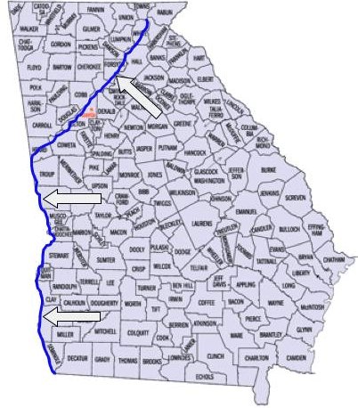
(SS8G1c) Body of water that runs through Atlanta and makes up part of Georgia�s border withAlabama is?
Savannah River
Tennessee River
Chattahoochee River
Yellow River
(SS8G1a) Georgia is located in which nation?
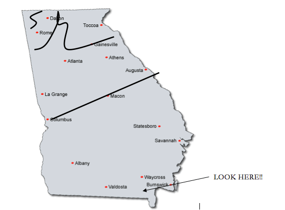
The term annual means...
yearly
Almanac
annuity
monthly


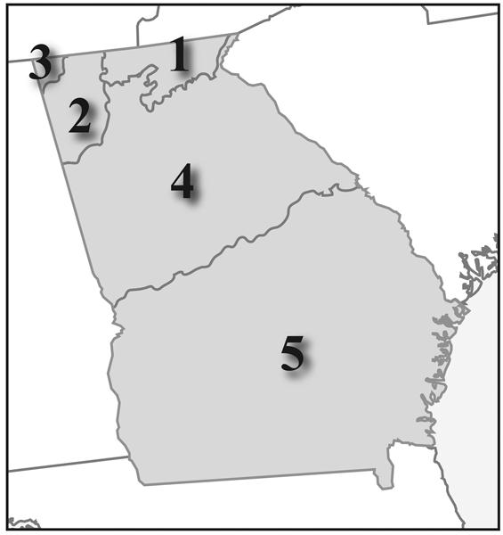
Which area on the map would be MOST likely to have many active seaports?

Any form of rain, snow, sleet, or hail that falls to the ground.
precipitation
Region of Georgia that includes the capital city of Atlanta.
Blue Ridge
Valley and RIdge
Appalachian Plateau
Piedmont
How many states are in the continental United States of America?
50
48
51
49
Located in the Blue Ridge, is the highest waterfall in Georgia; the name is derived from a Cherokee language word meaning "tumbling waters".
Amicalola Falls
Tallulah Falls
Niagara Falls
Brasstown Falls
Located in the Ridge and Valley region of Georgia, Its is known as "The carpet capital of the world", or at least it likes to think so.
Dalton
Macon
Valdosta
Atlanta
Located in the Appalachian Plateau region of Georgia where Tennessee, Alabama, and Georgia come together.
NW Georgia
TAG Corner
Blue RIdge Mountains
Coastal Plains
Which states are not a part of the continental United States of America?
New Mexico, Washington DC
Alaska, Hawaii
Puerto Rico, Hawaii, Alaska
Washington DC, Puerto Rico
100 miles of interlocking chain of marshes, rivers and tributaries, they protect the beaches by blocking much of the wind, sands, and water that could erode the mainland.
Ridge and Valley
Georgia Coastal Islands
Hawaiian Island
The Barrier Islands
What continent is Georgia located in?
United States of America
North America
South America
Europe
Name the state capital location for Georgia.
Albany
Savannah
Macon
Atlanta
The _______is the largest region, covering roughly 60% of the state.
Piedmont
Fall Line
Coastal Plain
Blue Ridge
Nearly 50% of Georgia’s population lives in this region, thanks to cities like Atlanta, Athens, Macon, Columbus, Augusta, and Milledgeville.
Valley and Ridge
Piedmont
Appalachian Plateau
Coastal Plain
The ________ has good farmland and produces the majority of the state’s crops.
Blue Ridge
Piedmont
Valley and Ridge
Coastal Plain
The movement of people/ideas from one location or country to another thus affecting all societies.
human environment interaction
GPS
migration
societal sharing
The study of the interrelationship between people and their physical environment.
human environment interaction
geography
geology
Migration geology
It was once a part of the Atlantic Ocean floor. It’s name comes from an Indian word that means “land of the trembling earth.”
Cherokee Wetlands
The Okefenokee Swamp
The Chattahoochee RIver
Savannah RIver
Georgia’s 3 northern geographical regions are all a part of the ________ range.
Blue Ridge Mountain
Appalachian Mountain
Rocky Mountain
Sierra Madre Mountain
The ________ is a natural boundary that separates the Piedmont and the Coastal Plain regions.
Natural boundary
Fall Line
Piedmont Plateau
Coastal Plain
Which two rivers are on the eastern and western borders of the Fall Line?
Chattahoochee and Flint Rivers
Savannah and Chattahoochee Rivers
Savannah and Flint Rivers
Okefenokee and Barrier Rivers
What does the word navigate mean?
To sail or travel.
Finding of a location
A way of using GPS coordinates to locate an absolute location.
None of the above
The __________ found on the fall line caused many rivers in the area to be difficult to navigate.
rough and rocky waters
Low water
underwater currents
waterfalls
The waterfalls located along the Fall Line offers sources of _____________ and many mills.
fresh water
gold
hydropower
fish
What type of energy is created by the waterfalls along the Fall line?
Electricity made by generators that are turned by the movement of water.
Solar power created by the movement of water.
Energy caused from the movement of windmills
Georgia is by far the leading ________producing state in America and is recognized as a world leader in the mining, production, processing, and application of kaolin products.
waterfalls
clay
gold
water power
In addition, many of Georgia’s most important cities such as ____ , _____, and _______were located on the fall line due to their location as the last navigable upstream points in the state.
None of the above
Atlanta, Savannah and Macon
Columbus, Macon and Atlanta
Columbus, Macon, and Augusta
_________most commonly used in the paper-coating industry. It is also used as a filler (added to plastics, for example, and rubber compounds), as a pigment additive in paints, in ceramics (tile, chinaware, and bathroom toilets and sinks), and in pharmaceuticals such as toothpaste.
mineral oil
kaolin
ceramic
mineral mud
The most famous Indian tribe that lived in the swamp was the ________, which fought two wars against the United States in the Okefenokee area.
Cherokee
Seminole
Muscogee
Creek
The Okenfenokee Swamp is located in the _______ portion of the state.
northeast
southeast
western
southwestern
Which swamp is the largest swamp in all of North America?
The Everglades
Lanier
Okeechobee
Okefenokee
The Okenfenokee Swamp was a major source of _______
kaolin
Vidalia Onions
fish
timber
The most well known animal protected in the Okefenokee Swamp is the being the _______.
bear
coyote
crane
American alligator
In the southern states these mountains are often called the __________ due to the blue haze that appears around their peaks.
Blue Ridge
Appalachian
Appalachian
Rocky Mountains
The highest peak in the continental United States is _________ which is almost 14,500 feet.
Blue Ridge Mountain
Appalachian Plateau
Brasstown Bald
Mt. Whitney
Which region of Georgia is the beginning of the Chattahoochee River?
Valley and Ridge
Piedmont
Appalachian
Blue Ridge
The Chattahoochee River forms part of the border between the states of _______ and _________.
Georgia and South Carolina
Georgia and Alabama
Georgia and Florida
Georgia and Tennessee
Today, the Chattahoochee is used primarily as a ________source for the millions of Georgians living in the Piedmont area.
water source
hydroelectric power
recreation
fishing
The states of ______ and ________ have sued Georgia due to its unrestricted rights over the use of the river.
Tennessee and Florida
North Carolina and South Carolina
Alabama and Mississippi
Florida and Alabama
Due to the _______ the Chattahoochee becomes difficult to navigate between the Piedmont and Coastal Plain regions
hydroelectric power
Fall Line
shallow water
underwater currents
One of Georgia’s longest waterways, the Savannah River begins in Hart County, forms _______, and then flows to the __________.
Lake Hartwell and Atlantic Ocean
Lake Lanier and Gulf of Mexico
Blue Ridge Mountains and Atlantic Ocean
What is the name of Georgia's first and oldest city ________, which was built along the Savannah River?
Savannah
Atlanta
Columbus
Macon
The Savannah River is a major source of
shipping, fishing, to cool two nuclear power plants in South Carolina, and to generate solar power.
recreation, beaches, drinking water,
shipping, drinking water, to cool two nuclear power plants in South Carolina, and to generate hydroelectric power.
Today, the Barrier islands are mainly ________and _________destinations though the fishing and paper industries are still important economic enterprises.
mining and timber
recreation and tourism
shipping and tourism
How many Barrier islands are there in Georgia?
14
5
20
10
The Barrier Islands protect the mainland from ______ and _____ erosion.
wind and water
forest fires
oil spills and water
During the Colonial and Antebellum periods, ______ were set up on the barrier islands to grow products such as rice and indigo.
cities
educational systems
plantations
stores
Which Georgia waterway borders the Barrier Islands.
Atlantic Ocean
Flint River
Savannah River
Chattahoochee River
Georgia has a ___________climate with hot summers and mild winters
hot and humid
rainy
humid subtropical,
cold
Which areas of Georgia tend to be cooler than the rest of the state.
lakes and rivers
coastal beaches
mountains
south Georgia
Georgia is prone to_____ and often feels the effects of hurricanes, though the state has not been hit directly since 1898.
earthquakes
tornadoes
snow storms
tidal waves
What is the number one industry in the state of Georgia?
tourism
music
movie
agriculture
Georgia is the _____ most populated state in the United States of America.
19
25
9
35

