wayground logo

Free Printable Worksheets

Font size

S
M
L
XL
Worksheets

Geography Foundations- maps, themes, weathering, tectonic plates

Total questions: 82

Worksheet time: 3hrs 33mins

Name
Class
Date
1.

According to the map, Michigan is _________ of Wisconsin.

a)

North

b)

South

c)

East

d)

West

2.

According to the map, which state is west of Nevada?

a)

Utah

b)

California

c)

Idaho

d)

Arizona

3.

What symbol on a map indicates direction?

a)

the scale

b)

the key

c)

the compass rose

d)

the legend

4.

What are the cardinal directions?

a)

the direction the Earth rotates

b)

the direction birds fly in the winter

c)

northeast, southeast, northwest, southwest

d)

north, south, east, west

5.

What are the intermediate directions?

a)

north, south, west, east

b)

northwest, southwest, northeast, southeast

c)

the direction the Earth rotates

d)

the direction all students walk to Northwest Middle School

6.

What are the five themes of Geography?

a)

movement, human-environment interaction, earth, location, region

b)

movement, human-environment interaction, place, direction, region

c)

movement, human-environment interaction, place, location, region

d)

motion, human-environment interaction, place, location, region

7.

What are the four layers of Earth?

a)

inner core, outer core, mantle, soil

b)

inner core, outer core, magma, crust

c)

inner core, outer mantle, inner mantle, crust

d)

inner core, outer core, mantle, crust

8.

The mantle is made of

a)

molten (melted) rock

b)

molten (melted) metal

c)

solid rock

d)

solid metal

9.

What is human-environment interaction?

a)

how humans travel on Earth

b)

how humans affect Earth, and how Earth affects humans

c)

how Earth's environment affects its orbit in space

d)

how Earth rotates on its axis, and how it revolves around the sun

10.
Measures distance from the equator. These lines run east and west and measure north and south.
a)
Cardinal Directions
b)
Latitude Lines
c)
Longitude Lines
d)
Intermediate Directions
11.
__________ identifies distances on a map.  It refers to the relationship (or ratio) between distance on a map and the matching distance on the earth.
a)
Map Scale
b)
Cardinal Directions
c)
Intermediate Directions
d)
Symbols
12.
This type of map shows physical features of the land, including valleys, canyons, plains, and mountains.
a)
Political
b)
Physical
c)
Time Zones
d)
Map Key
13.
__________ directions are northeast, southeast, southwest, and northwest.
a)
Latitude
b)
Cardinal
c)
Intermediate
d)
Longitudinal
14.
A _________ is used to represent real objects on the map such as a building, road, lake, tree, mountain, etc.
a)
Symbol
b)
Compass Rose
c)
Map Scale
d)
Merdian
15.
__________ measures distance from the Prime Meridian.  These imaginary lines run from the north pole to the south pole.  These lines run north and south and measure east or wes
a)
Latitude 
b)
Longitude
c)
Lines
d)
Equator
16.
 A __________ is used to identify the direction of north, south, east, and west.
a)
Compass Rose
b)
Map Scale
c)
Latitude Lines
d)
Longitude Lines
17.
The __________ directions are north, east, south, and west.
a)
cardinal
b)
intermediate
c)
map
d)
most imprtant
18.
 This type of map shows governmental boundaries of countries, states, and/or counties.  It sometimes includes cities, roads, and significant bodies of water.
a)
Physical
b)
Political
c)
Product
d)
Map
19.
 A __________ is used to identify what the symbols on the map stand for.  The meaning of the symbol may be explained using this.
a)
Physical Map
b)
Map Key
c)
Compass Rose
d)
Map
20.
 The red question mark is located to the _________ of the compass rose.
a)
Southwest
b)
Southeast
c)
South
d)
West
21.
What is the name of the line at 0 degrees latitude?
a)
Equator
b)
Prime Meridian
c)
International Date Line
d)
Arctic Circle
22.
What is the name of the line at 0 degrees longitude?
a)
Equator
b)
Prime Meridian
c)
International Date Line
d)
Arctic Circle
23.
Latitude and longitude are measured in ________.
a)
inches
b)
feet
c)
degrees
d)
grams
24.
Latitude lines MEASURE the distance  __________ and ________ of the equator.
a)
North and South
b)
East and West
25.
Longitude lines measure the distance _________ and ___________ of the prime meridian.
a)
North and South
b)
East and West
26.
Which theme of geography tells your WHERE something is?
a)
Location
b)
Place
c)
HEI
d)
Movement
27.
Which theme of geography discusses the TRAVEL of people, objects or ideas?
a)
Location
b)
Region
c)
HEI
d)
Movement
28.
Which theme of geography DESCRIBES what a place looks like?
a)
Location
b)
Place
c)
Region
d)
HEI
29.
Which theme of geography is the CHANGE of humans and the environment?
a)
Place
b)
Region
c)
HEI
d)
Movement
30.
Which theme of geography GROUPS places together that are SIMILAR?
a)
Location
b)
Place
c)
Region
d)
Movement
31.
What is a Region
a)
Tells us ways in which the places in an area are alike
b)
Tells us what makes an area special and what makes it different from every other area
c)
Tells us where people and places are
32.
What is movement?
a)
Tells us how people, goods, recourses, and ideas move from one place to another
b)
Tells us what makes an area special and what makes it different from every other area
c)
Tells us ways in which the places in an area are alike.
33.
What is location?
a)
Tells us where people and places are
b)
Tells us what makes an area special and what makes it different from every other area.
c)
Tells how people, goods, resources, and ideas move from one place to another.
34.
Cutting down trees to build houses is an example of which?
a)
Location
b)
Place
c)
Human-Environment Interaction
d)
Movement
35.
People leaving their homes in Syria and travelling to Turkey to avoid ISIS is an example of which?
a)
Human-Environment Interaction
b)
Movement
c)
Absolute Location
d)
Relative Location
36.
The fact that Africa is south of Europe is an example of which?
a)
Movement
b)
Absolute Location
c)
Relative Location
d)
Place
37.
The European Union is a group of countries that share similar economic and government policies, in addition to all being located near one another and sharing a common history.
a)
Human Environment Interaction
b)
Place
c)
Region
d)
Location
38.
The states in the area known as the "Southwest" of the United States are often grouped together because they are very hot and dry desert-like areas.
a)
Region
b)
Location
c)
Human Environment Interaction
d)
Movement
39.

A scale model of the Earth that depicts properties such as area, distance,an direction.

a)

Maps Projections

b)

Globes

c)

Great Circle Route

d)

Maps

40.

What do we call Cartographers

a)

Make Maps

b)

Map Maker

c)

Globe Makers

d)

2-D Makers

41.

Why does distortion occur on every map?

a)

Cartographers are politically biased.

b)

GIS technology encourages errors.

c)

The 3D world cannot be accurately converted to 2D

42.

The changes in the seasons is due to

a)

Rotation

b)

Revolution

c)

Tilt of the axis

d)

All the three

43.

When it is spring in Northern hemisphere, the southern hemisphere has ___________.

a)

Summer

b)

Spring

c)

Winter

d)

Autumn

44.
How long does it take for the Earth to rotate once?
a)
24 hours
b)
365 days
c)
27.3 days
d)
27.3 hours
45.
Which of the following would be true about the Northern Hemisphere? 
a)
It is experiencing the autumnal equinox. 
b)
It is experiencing the vernal equinox.
c)
It is experiencing the summer solstice.
d)
It is experiencing the winter solstice.
46.
An equinox occurs when the Sun is positioned directly over the equator. 
a)
True
b)
False
47.
What are the days of the year when day and light hours are equal?
a)
Solstices
b)
Seasons
c)
Daylight savings time
d)
Equinoxes
48.
What are the reasons for the seasons?
a)
Earth's tilt and rotation.
b)
Earth's rotation and revolution.
c)
Earth's tilt and revolution.
d)
Earth's tilt and resolution
49.
What is the longest day of the year?
a)
winter solstice
b)
summer solstice
c)
fall equinox
d)
spring equinox
50.
This is the reason we experience day and night
a)
rotation
b)
revolution
51.
Which season has the least amount of daylight in the Northern Hemisphere?
a)
Winter
b)
Spring
c)
Summer 
d)
Fall
52.
The natural chemical or physical processes that breaks down rock on Earth's surface.
a)
weathering
b)
erosion
c)
deposition
d)
jackhammering
53.
The process by which water, ice, wind or gravity moves weathered rock and soil from one place to another.
a)
weathering
b)
erosion
c)
deposition
d)
dumptruck
54.
This type of weathering occurs when rocks weaken then break down due to chemical changes in the composition of the rock.
a)
mechanical weathering
b)
chemical weathering
c)
erosion weathering
d)
deposition
55.
This type of weathering occurs when rock is physically broken down into smaller pieces of rock.
a)
mechanical weathering
b)
chemical weathering
c)
erosion weathering
d)
deposition
56.
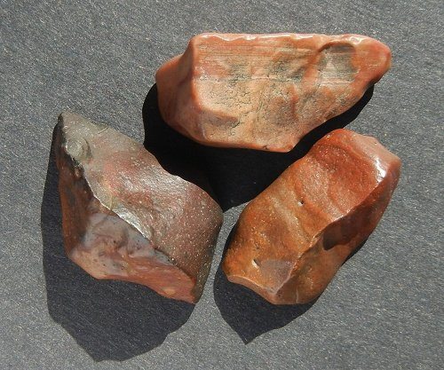
These rocks were made smooth by wind blowing smaller rock particles across their surface.  This is an example of:
a)
ice wedging
b)
chemical weathering
c)
acid rain
d)
abrasion
57.
How might a weathered mountain appear different than an unweathered mountain?
a)
Weathered mountain would be taller.
b)
Weathered mountain would be rounder and less jagged.
c)
Weathered mountain would be more jagged and less rounded.
d)
Weathered mountain would have no trees.
58.
How is mechanical weathering different from chemical weathering?
a)
Chemical weathering happens over much shorter time frame than mechanical weathering.
b)
Chemical weathering changes the chemical composition of rocks; mechanical weathering does not.
c)
Chemical weathering occurs only in tropical climates; mechanical weathering occurs only in cool climates.
d)
Chemical weathering occurs only in the mountains; mechanical weathering occurs only on flat land.
59.
Weeds growing into the cracks in a sidewalk and the sidewalk begins to crumble is an example of:
a)
mechanical weathering
b)
chemical weathering
60.
A metal statue slowly turning green after years of being outside is an example of:
a)
mechanical weathering
b)
chemical weathering
61.
Flood water pounding against a canyon wall and wearing it down
a)
Weathering
b)
Erosion
c)
Deposition
62.
Rain washing away soil from a hillside
a)
Weathering
b)
Erosion
c)
Deposition
63.
Glaciers dropping rock and sand to form moraines (deposition of debris)
a)
Weathering
b)
Erosion
c)
Deposition
64.
Waves dropping sand on the beach
a)
Weathering 
b)
Erosion
c)
Deposition
65.
Water getting into cracks, freezing, and breaking the rocks or pavement apart
a)
Weathering
b)
Erosion
c)
Deposition
66.
Name this boundary
a)
Convergent
b)
Divergent
c)
Transform
d)
Sergent
67.
Name the boundary
a)
divergent
b)
convergent
c)
transform
d)
sergent
68.
Name the boundary
a)
convergent
b)
transform
c)
divergent
d)
sergent
69.
Which of the following is associated with transform boundary?
a)
volcanoes
b)
mountains
c)
trenches
d)
earthquakes and fault line
70.
Earth's plates are....
a)
Constantly moving and changing the face of the Earth
b)
Never moved
c)
Move seldom and very fast
d)
move when they feel like it
71.
Plate movement is caused by _____
a)
The rotation of the Earth
b)
Ocean tides
c)
Convection current in the mantle
d)
The moon's gravity
72.
What is a break in the rock layers called?
a)
Earthquake
b)
Epicenter
c)
Fault
d)
Focus
73.
Which scale measures the intensity of the ground movement?
a)
Mercalli Scale
b)
Richter Scale
c)
Seismogram Scale
d)
Bernoulli Scale
74.
Which most likely causes earthquakes?
a)
plates slipping 
b)
a hurricane 
c)
water weathering rocks
d)
tidal stresses caused by the moon
75.
What is a constructive force?
a)
an earthquake
b)
a volcanic eruption
c)
a flood 
d)
 a wind storm
76.
What causes islands to form?
a)
tsunamis
b)
severe storms
c)
volcanic eruptions
d)
erosion
77.

What is magma called when it reaches the surface of Earth?

a)

Lava

b)

viscosity

c)

toxic gas

78.

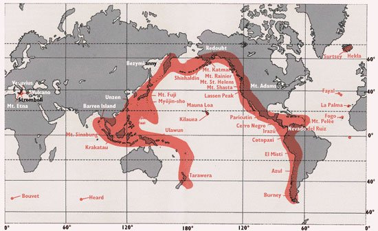
This is the name for the chain of volcanos around the edge of the Pacific Plate.

a)

March Maddness

b)

Earthquake Alley

c)

Ring of Fire

d)

Circle of Death

79.
What is the shaking of the Earth’s crust caused by a release of energy?
a)
Earthquake
b)
Epicenter
c)
Fault
d)
Plate
80.

What is a large ocean wave that results from an underwater earthquake, landslide, or volcanic eruption?

a)

Tsunami

b)

Liquefaction

c)

Seismic Gap

81.

The huge pieces of the earth's crust are called ____________________________.

a)

cups

b)

plates

c)

dishes

d)

spoons

82.

What type of boundary is shown in the diagram?

a)

Divergent

b)

Convergent

c)

Transform