
 Worksheets
Unit 1 and 2 Retest Review
Total questions: 50
Worksheet time: 24mins
Which map feature can help you determine the approximate distance between two locations?
map scale
key
title
distance calculator

What does GPS tell a user?
Absolute location
Relative location
Region
Elevation
The Equator is measured at _______________ and divides the Northern Hemisphere from the Southern Hemisphere.
0 degrees Longitude
180 degrees Longitude
0 degrees Latitude
90 degrees South

Himalayan Mountains
converging continent to continent
earthquake in subduction zone
converging ocean to continent
transformational

What is happening at this boundary?
A rift valley forms
Mountains are forming
The ocean is sinking
Volcanoes form
During an equinox, the Sun is directly above the?
Tropic of Capricorn
Tropic of Cancer
Equator
Santa's Workshop
The Tropic of Cancer is located at:
North of the Equator (Northern Hemisphere)
South of the Equator (Southern Hemisphere)
West of the Prime Meridian (Western Hemisphere)
East of the Prime Meridian (Eastern Hemisphere)
Which of the following best describes a formal region?
The area served by a local newspaper.
The Middle East, based on shared cultural perceptions.
The Rocky Mountains, defined by physical geography.
The bus routes connected to a central station.

A planar projection map is most useful for:
Finding the shortest distance between two places, particularly at the Poles
Visualizing the overall shape and size of land
Sea navigation
Mapping the continents

A mathematical formula used to represent the curved surface of the Earth on the flat surface of a map is called a...
a cylindrical projection
a planar projection
map projection
conic projection

The line of longitude that is located at zero degrees is called what?
Prime Meridian
Equator
Tropic of Capricorn
Optimus Prime

Why is the Equator the warmest?
Because it is closest to the sun.
Because it receives the most direct sunlight.
Because no clouds form here.
Because it is far from the sun.

Do the tropics have all four seasons?
Yes, they have all four days.
Yes, they have all four seasons.
No, they only have summer.
No, they have no seasons; it is warm all year round.
The earth rotates once every
24 hours
15 hours
365 days
hour
Which statement best explains the relationship between latitude and temperature?
Latitude has no effect on temperature.
Temperatures decrease as latitude increases away from the equator.
High latitude = warmer temperatures.
Temperatures increase the farther you move from the equator.
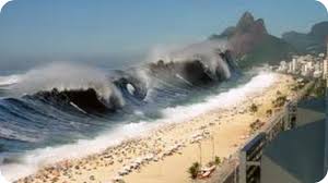
A long, high sea wave caused by an underwater earthquake, landslide, or underwater volcano that causes major coastal damage is called a
Typhoon
Flood
Tornado
Tsunami
The _________ are windless zones near the equator.
doldrums
prevailing westerlies
polar easterlies
trade winds

The invisible line at 0 degrees latitude that divides the Earth into the Northern and Southern Hemispheres is called the ________.
International Date Line
Prime Meridian
Equator
Arctic Circle
What is a drought?
The measure of how dry an area of land is.
When the conditions are drier than normal.
When the temperature is higher than normal.
When the precipitation levels are higher than normal.
Two factors that determine climate are
precipitation and temperature
hurricanes and tornadoes
humidity and pressure

Which of the following does NOT have an effect on a region's climate?
Large bodies of water
Latitude
Mountains
Longitude


Which state is located at
120°W, 45°N?
WA
OR
UT
ND

What is the name of the ocean labeled 2?
Indian Ocean
Arctic Ocean
Atlantic Ocean
Southern Ocean

Name the ocean labeled '1'.
Pacific Ocean
Indian Ocean
Arctic Ocean
Southern Ocean

Identify this map.
Political map
Thematic map
Physical map
The _______ of a mountain range is the side that receives a lot of precipitation.
tropical side
leeward/dry side
windward/wet side
cloudy side

What is significant about the area between the Tropic of Cancer and the Tropic of Capricorn?
It is more prone to earthquakes.
Cold water currents keep it temperate in the spring.
The Earth rotates faster in this zone.
It gets direct sunlight year-round.

The rain shadow is shown at ____.
A
B
C
D

What do the revolution and tilt of the Earth cause?
Tectonic Movement
Seasons
Rainshadow
Tides
Both El Niño and La Niña have this in common:
Influence birds that migrate over the ocean
Influence rainy/dry weather worldwide
The weather at the polar regions
The directions that ships travel in the oceans
Which two biomes receive the least precipitation?
tropical rain forest and temperate grassland
savanna and tropical dry forest
tundra and desert
boreal forest and temperate woodland

This biome is found around the equator and is home to a large amount of biodiversity.
Deserts
Tropical Rainforests
Savannas
Chaparral

In a _____________________ climate, it is extremely cold. Even in summer, the temperature never goes higher than 50℉.
Continental
Dry
Polar
Temperate
Tropical
Which climate zone is known for having four distinct seasons?
Tropical
Polar
Temperate
Arid
What is weathering?
The movement of sediment
The breaking down of sediment
The dropping of sediment
What is erosion?
The movement of sediment
The breaking of sediment
The dropping of sediment
Mark is looking for the best neighborhood to build a home. He is looking for his _____________
GIS
GPS
Formal Region
Location
I have layered data that shows me the best area to buy a house. It shows the land, crime, and income of the area. This is
GPS
GIS
MR. HeLP
Regions
What is the best example of GPS?
Looking for traffic in my area
Looking for the crime rate in my neighborhood
Looking at how far my friend lives
Looking for the weather

Which GeoTerm best explains this image?
Absolute Location
Relative Location
Distortion
Map Projection
What helps a geographer find the distance on a map?
Key
Legend
Scale
Map Grid
What is a mapmaker called?
A map maker
A geographer
A scientist
A cartographer

What is this?
flood
hail
thunderstorm
blizzard
Tornadoes in the United States occur most frequently in an area called...
Tornadoville
Hurricane Alley
Tornado Alley
California Coast
In the western North Pacific and Philippines, hurricane type systems are called...
...rain makers.
..."typhoons"
...Twister.

Identify the map above and identify which of the following descriptions most accurately describes the map.
Mercator: The shape and size of land masses are distorted, but direction is accurate
Robinson: Distortion is only happening with the size of the land masses, shape and direction are accurate
Mercator: Land mass size is accurate due to distortion being spread across all aspects of the map
Goode Homolosine: Does not use cardinal directions, minimizes distortion but is confusing to read
Robinson: Distortion is evenly spread out across shape, size, and direction making it less noticeable

What climate zone is the green area in the picture?
Polar zone
Temperate zone
Tropical zone

