
 Worksheets
Unit 1: Location
Total questions: 32
Worksheet time: 17mins
Which two hemispheres best describe Jeannette's location?
Northern and Southern
Northern and Eastern
Southern and Eastern
Northern and Western
Geography is the study of Earth's ______________ and _____________ features.
physical and human
natural and animal
human and culture
physical and environmental
Where a place is on Earth is known as its __________________.
place
location
stop
human environment interaction
Which of the following are examples of absolute location?
40 ° N, 75 ° E
Jeannette is southeast of Pittsburgh
The school's address is 800 Florida Ave.
The United States is in the Northern hemisphere
Name Jeannette's county.
Allegheny
United States
Westmoreland
Hempfield Township
True or False: Latitude describes how far east or west you are from the prime meridian.
True
False
A hemisphere is best described by which of the following?
half of the earth
a quarter of the earth
part of a sphere
the part above the equator
What is the purpose of a map legend?
explains what the colors on the map mean
explains the symbols on the map
gives information about the map
shows direction on the map
Jeannette is located in the southwestern corner of which state?
California
Montana
Pennsylvania
Maryland
True or False: Longitude describes how far east or west a location is from the prime meridian.
True
False

Which letter would have the coordinates of
60 ° N, 60 ° E?
A
B
C
D
What are the cardinal directions found on a compass?
north only
north, east, south, west
northeast, southeast, northwest, southwest
north, east, south, west, northeast, southeast, southwest, northwest
Which of the following are examples of relative location?
40 ° S, 105 ° E
the high school is by the water tower
Dollar General is in downtown Jeannette
the high school's address is 800 Florida Ave.
Jeannette is located on which continent?
United States
North America
South America
Pennsylvania
Scale on a map refers to which of the following?
how much the map weighs
the distance on the map compared to actual distance on Earth
a range of musical notes for the map
none of these
What does the map title tell us?
what the map is about
who the author of the map is
how to read the map
all of these

This image is an example of which map feature?
legend
title
scale
compass
Name the imaginary line that divides the earth into the Eastern and Western hemispheres.
equator
Prime Meridian
International Date Line
Tropic of Capricorn
Name the imaginary line that divides the Earth into the Northern and Southern hemispheres.
equator
Prime Meridian
Arctic Circle
International Date Line

According to the map, which city has a population of under 10,000?
Junction City
Friendly Corner
Quie Valley
Old Mill Rd.

Where would be the best place to find a campsite, according to the map?
by the lake
in the mountains
on Interstate 23
in the forest

Which of the following describes the relative location of France?
South of the United Kingdom
Northeast of Spain
East of the Bay of Biscay
West of Germany, Belgium, Switzerland, and Italy

Name this map feature.
scale
legend
compass
title
Which would you use to give directions to your house?
Absolute location
Relative location
both
neither

Which type of map is shown here?
Political
Resource
Political
Topographic

Which type of map is pictured here?
Political
Thematic
Resource
Topographic
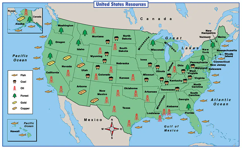
Which type of map is pictured here?
Political
Topographic
Resource
Physical

Which type of map is pictured here?
Political
Thematic
Physical
Resource


The directions of Northwest, Northeast, Southwest, Southeast are known as which of the following?
Cardinal Directions
Intermediate Directions
Middle Directions
Compound Directions

Which is the correct order from north to south for this lines of latitude?
Arctic Circle, Tropic of Cancer, Equator, Tropic of Capricorn, and Antarctica Circle
Tropic of Capricorn, Arctic Circle, Equator, Tropic of Cancer, and Antarctica Circle
Antarctic Circle, Tropic of Capricorn, Equator, Tropic of Cancer, Arctic Circle
Equator, Arctic Circle, Antarctic Circle, Tropic of Cancer, Tropic of Capricorn

