wayground logo

Free Printable Worksheets

Font size

S
M
L
XL
Worksheets

WG CBA 1 Review (Part 2)

Total questions: 43

Worksheet time: 22mins

Name
Class
Date
1.

Which map would have the smallest scale?

a)

world map

b)

Bedford map

c)

Texas map

d)

U.S. map

2.

How can GPS be used? (Choose all that apply)

a)

track migration patterns of animals

b)

determine locations of earthquakes

c)

build layered maps

d)

giver personal directions

3.

What geographic tool uses data to layer information onto maps?

a)

global positioning system

b)

geographic information systems

c)

map projections

d)

remote sensing

4.

Which type of map would be best for a person traveling on a mountain trail on foot?

a)

a large scale physical map

b)

a small scale physical map

c)

a large scale political map

d)

a small scale political map

5.

Line E is

a)

The Equator

b)

The Prime Meridian

c)

The Tropic of Cancer

d)

The Tropic of Capricorn

6.

Point A is

a)

90°N

b)

90°S

c)

66 1/2°N

d)

66 1/2°S

7.

Line C is

a)

The Arctic Circle

b)

The Antarctic Circle

c)

The Tropic of Cancer

d)

The Tropic of Capricorn

8.

Line D is

a)

The Equator

b)

The Prime Meridian

c)

The Tropic of Cancer

d)

The Tropic of Capricorn

9.

Line B is

a)

The Arctic Circle

b)

The Antarctic Circle

c)

The Tropic of Cancer

d)

The Tropic of Capricorn

10.
Which two continents are located entirely in the Western Hemisphere?
a)
Europe and Africa
b)
Europe and Africa
c)
North America and Australia
d)
North America and South America
11.
A meridian of longitude is an imaginary line that runs
a)
parallel to the Arctic Circle.
b)
B. parallel to the Tropic of Cancer.
c)
from the North Pole to the South Pole.
d)
from the Prime Meridian to the
International Date Line.
12.
What is the longest day of the year?
a)
winter solstice
b)
summer solstice
c)
fall equinox
d)
spring equinox
13.
What does the relative location of a place tell you?
a)
A. the longitude and latitude of a place
b)
which symbol shows a place on a map
c)
where a place is compared to another place
d)
D. the map projection being used to show
a place
14.
The term equinox means....
a)
equal amount of day light and equal amount of night
b)
Equal amount of winter and summer
c)
Equal amounts of hot dogs for everyone
d)
The longest day of the year
15.

Answers the question: "How are areas similar or united (physically, politically, or culturally) to other areas around them?"

a)

Movement

b)

Absolute Location

c)

Region

d)

Place

16.

Answers the question: "In what ways do people adapt to their environment, or change their environment in order to meet their needs?"

a)

Human Environment Interaction

b)

Place

c)

Location

d)

Region

17.

Answers the question: "How do people, plants, animals, and ideas move through out time and place?"

a)

Place

b)

Location

c)

Region

d)

Movement

18.

Answers the question: "Where is it in relation to other areas or things?"

a)

Place

b)

Perfect Location

c)

Absolute Location

d)

Relative Location

19.

Answers the question: "Where is it exactly on the Earth?"

a)

Place

b)

Perfect Location

c)

Absolute Location

d)

Relative Location

20.

Answers the question: "Where is it?"

a)

Place

b)

Location

c)

Movement

d)

Region

21.

Answers the question: "What is it like?"

a)

Place

b)

Location

c)

Human Environment Interaction

d)

Movement

22.
Which physical feature is in this image?
a)
Great Basin
b)
Great Plains
c)
Canadian Shield
d)
Vancouver Island
23.
Which resource is most abundant in Texas, Alaska, and Alberta?
a)
precious metals
b)
petrolium
c)
hydroelectric power
d)
coal
24.
What mountains are in this image?
a)
Rocky Mountains
b)
Appalachian Mountains
c)
Sierra Nevada Mountains
d)
Mount McKinley
25.
What are 3 states, provinces, territories that the Rocky Mountains run through? 
a)
Nevada, Rhode Island, Delaware
b)
British Columbia, Texas, Alabama
c)
Colorado, Alberta, Alaska
d)
California, Washington, Vermont
26.
Which definition best matches the term population density?
a)
human beings in general
b)
number of people in a particular area
c)
A measurement of people for a specific area
d)
All the inhabitants of a particular area
27.
Is the city in climograph “A” or climograph “B” in the Southern Hemisphere?
a)
A
b)
B
28.
Identify this projection
a)
Robinson
b)
Winkel Tripel
c)
Polar
d)
Mercator
29.
Why is the Equator warmest?
a)
Because it is closest to the sun.
b)
Because it receives the most direct sunlight
c)
Because no clouds form here.
d)
Because it is far from the sun
30.
According the population pyramid Canada's population is _______________ 
a)
growing
b)
getting smaller
c)
staying the same 
31.
According to the population pyramid of this country, its population is most likely...
a)
growing slowly.
b)
growing rapidly.
c)
decreasing.
d)
not changing.
32.
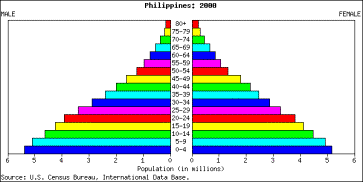
This population pyramid shows a country with a population that is 
a)
Growing
b)
Stable (Staying the Same)
c)
Shrinking
33.
This population pyramid shows a country that's population is 
a)
Growing
b)
Stable
c)
Shrinking
34.
This population pyramid shows a country with a population that  is 
a)
growing
b)
staying the same
c)
decreasing
35.

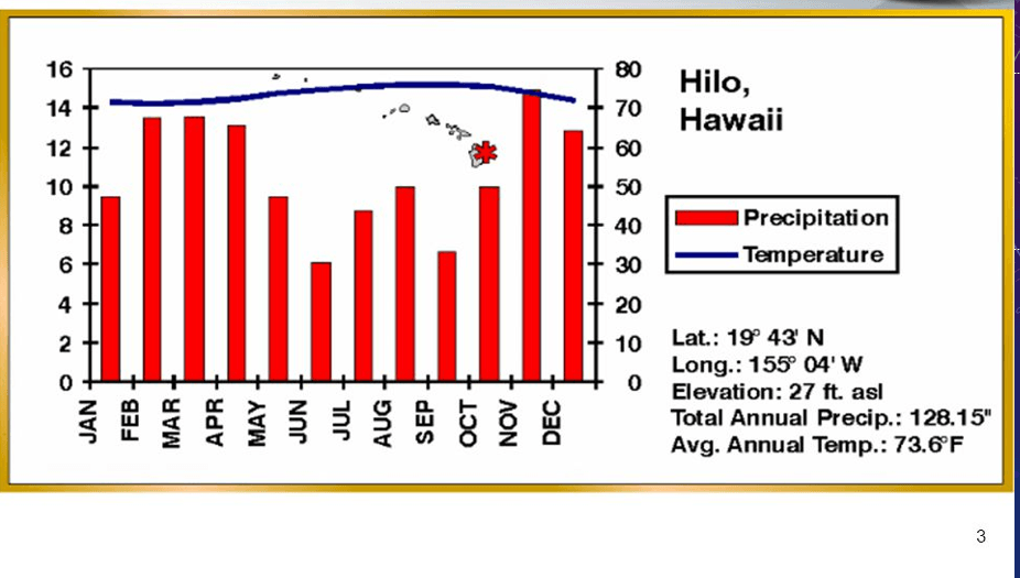
When is there the most precipitation & highest temperatures?

a)

February

b)

July

c)

September

d)

December

36.

Which months have the warmest temperatures?

a)

December, January, February

b)

March, April, May

c)

June, July, August

d)

September, October, November

37.

When does the least precipitation occur?

a)

February - March

b)

April - May

c)

June - July

d)

November - December

38.

In which month do they get the most rain in this biome?

a)

January

b)

May

c)

August

d)

November

39.
What type of forests cover parts of Alaska and much of Canada, filled with trees like pine, fir, cedar and spruce?
a)
Coniferous
b)
Deciduous
c)
Mixed forest
d)
Broadleaf evergreen forests
40.
What climate zone has cold weather all year with the ground that is always frozen?
a)
humid continental
b)
tropical wet and dry
c)
ice cap
d)
coniferous
41.
What is the largest city in Canada?
a)
Vancouver
b)
Montreal
c)
Ottawa
d)
Toranto
42.
What created the Great Lakes?
a)
mountains
b)
glaciers
c)
rivers
d)
ice
43.
Along what type of physical feature are hydroelectric power stations built?
a)
rivers
b)
hills
c)
mountains
d)
oceans