wayground logo

Free Printable Worksheets

NEW

Font size

S
M
L
XL
Worksheets

Unit 2 Review

Total questions: 45

Worksheet time: 1hrs 10mins

Name
Class
Date
1.
What is melted rock called that is below the Earth's surface?
a)
lava
b)
magma
c)
fossils
d)
crust
2.
Determine the contour interval:
a)
5 m
b)
10 m
c)
15 m
d)
20 m
3.
What is the contour interval of the topographic map below?
a)
400 m
b)
200 m
c)
100 m
d)
80 m
4.
What do contour lines that are farther apart represent?
a)
waterfall
b)
steep area
c)
gentle slope
d)
river
5.
If we were in a plane, Path B --> C is about the same distance as path E --> N. But, which path is the easier walk? 
a)
B --> C is the easier walk
b)
E --> N is the easier walk
c)
B --> C and E --> N are the same walking distance
6.

Which side is steeper?

a)

The left side of the hill

b)

The right side of the hill

7.

Match the topographic map to its profile.

a)
b)
c)
d)
8.

Which of the following best describes how mountains change over time?

a)

The elevation of the peaks will decrease due to erosion.

b)

The elevation of the peaks will increase due to weathering.

c)

The elevation of the peaks will increase due to deposition.

d)

Mountains stay the same, they never change.

9.
________ is the setting down of sediment.
a)
weathering
b)
erosion
c)
deposition
d)
compaction
10.
Valleys are created by what process?
a)
weathering
b)
erosion
c)
deposition
d)
cementation
11.
What is the landform made when rivers deposit sediment where they meet the ocean?
a)
delta
b)
terminal moraine
c)
sediment load
d)
flood plain
12.
Which type of plate is older?
a)
continental
b)
oceanic
13.
The German scientist who first proposed the Theory of Continental Drift 100 years ago?
a)
Harry Hess
b)
Penny Pangea
c)
Alfred Wegener
d)
Gary Gondwana
14.
All of the continents were once part of one large continent called...
a)
Panacea
b)
Pangea
c)
North America
d)
Gondwana
15.
What does the theory of continental drift state?
a)
The continents were once joined in a super-continent and have moved over time
b)
Continents are stationary and do not move
c)
The Earth is broken into lithospheric plates that move due to convection currents
d)
none of the above
16.
Why did other scientists have a hard time believing Wegeners theory of continental drift?
a)
He could not explain HOW the continents moved
b)
He didn't have enough evidence
c)
His evidence  was wrong
d)
He didn't use the right technology to gather data
17.
What two specific continents fit together most noticeably?
a)
Africa and North America
b)
South America and Europe
c)
South America and Africa
d)
Antartica and Africa
18.

Which of the following causes Earth's tectonic plates to move?

a)

Energy from the Sun

b)

Magnetic Pole Reversal

c)

Convection currents in the mantle

d)

Faults in Mountain Ranges

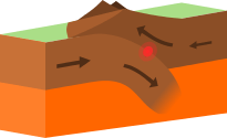
19.

What type of event will occur at this boundary?

a)

Earthquake

b)

Volcano Eruption

c)

Tornado

d)

Mountain Building

20.

A divergent boundary occurs when plates ....

a)

Pull apart

b)

Come together

c)

Slide past each other

d)

subducting

21.

The Great Rift Valley in Africa and the Mid-Ocean Ridge were all created by this boundary

a)

Divergent

b)

Convergent

c)

Reform

d)

Transform

22.

The tectonic plates float on the

a)

lithosphere

b)

lower mantle

c)

outer core

d)

asthenosphere

23.

What occurs when two plates come together and the denser one is forced under back into the mantle?

a)

reduction

b)

conduction

c)

subduction

d)

convection

24.

The youngest rocks on the seafloor are most likely found...

a)

closest to a mid-ocean ridge

b)

farthest from a mid-ocean ridge

c)

near the coastlines

d)

closest to a deep sea trench

25.

What geologic process formed the Himalayas?

a)

two continental plates converging

b)

an earthquake in a subduction zone

c)

a tectonic plate moving over a hot spot

d)

movement at a transform fault boundary

26.
What type of boundary is shown at A?
a)
transform
b)
convergent
c)
divergent
d)
subduction
27.
What is happening at point B?
a)
subduction
b)
a divergent boundary
c)
convection
d)
an earthquake
28.
What type of plate boundary is this?
a)
Plate
b)
Divergent
c)
Convergent
d)
Transform
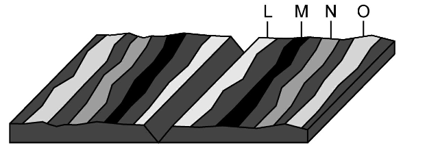
29.
Where would the oldest rock be found?
a)
L
b)
M
c)
N
d)
O
30.
During sea floor spreading, molten material rises up from the mantle...
a)
along the continents
b)
at the mid ocean ridges
c)
deep ocean trenches
d)
at north and south poles
31.
Which type of crust is more dense and thinner?
a)
Continental
b)
Asthenosphere
c)
Oceanic
d)
Byers
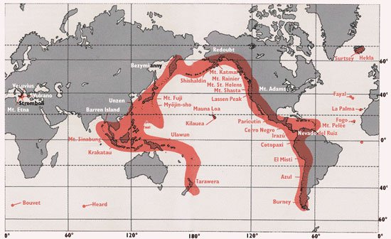
32.
This is the name for the chain of volcanos around the edge of the Pacific Plate.
a)
Circle of Fire
b)
Ring of Lava
c)
Ring of Fire
d)
Circle of Magma
33.

In sea-floor spreading, molten material rises from the mantle and erupts

a)

along the edges of all the continents.

b)

along mid-ocean ridges.

c)

in deep-ocean trenches.

d)

at the north and south poles.

34.

The process by which the ocean floor sinks beneath a deep-ocean trench and back into the mantle is known as _______

a)

convection.

b)

continental drift.

c)

subduction.

d)

conduction.

35.

Most geologists think that the movement of Earth’s plates is caused by _______

a)

convection.

b)

continental drift.

c)

subduction.

d)

conduction.

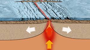
36.

Below is a picture of sea-floor spreading. How are the ocean crusts moving?

a)

Converging

b)

Diverging

c)

Sliding

d)

No movement

37.
The Andes Mountains are a volcanic mountain range located on the western coast of South America. The plate boundary located in this region is most likely an area of-
a)
subduction because the plates are colliding
b)
folded mountains because the plates are colliding
c)
mid-ocean ridges because the plates are pulling apart
d)
ocean-floor spreading because the plates are spreading apart
38.

The upper part of the mantle that is semisolid where convection pushes the tectonic plates

a)

Mantle

b)

Asthenosphere

c)

Lithosphere

d)

Crust

39.

Why does oceanic crust subduct under continental crust?

a)

Oceanic crust is thin

b)

Oceanic crust is dense

c)

Continental crust is thin

d)

Continental crust is dense

40.
The upper rigid part of Earth that contains the crust and part of the upper mantle is called the _________.
a)
asthensosphere
b)
inner core
c)
lithosphere
d)
glossoposphere
41.

The topographic map pictured here shows a river flowing in which direction?

a)

From north to south

b)

From south to north

c)

From east to west

d)

From west to east

42.

A landform made of sediment that is deposited where a river flows into an ocean or lake is called a...

a)

sea cave

b)

mountain

c)

delta

43.

Wegner used the following as pieces of evidence...

a)

fit/shape of continents

b)

geologic and fossil

c)

climate

d)

all of the above

44.
Provided is a topographic map of a hill with contour lines drawn showing elevation in meters.
The steepest slope on this hill can be found on the side that is facing which direction?
a)
Southwest
b)
Northeast
c)
Northwest
d)
Southeast
45.

In Seafloor Spreading, molten material rises from the mantle and erupts or flows out

a)

along the edges of all the continents

b)

in the deep ocean trenches

c)

along mid-ocean ridges

d)

in the north and south poles