wayground logo

Free Printable Worksheets

NEW

Font size

S
M
L
XL
Worksheets

Physical Africa

Total questions: 23

Worksheet time: 12mins

Name
Class
Date
1.
Which physical feature is located in East Africa? 
a)
Great Rift Valley 
b)
Congo Basin
c)
Cape of Good Hope 
d)
Sahara 
2.
The Great Rift Valley was formed mainly by 
a)
Shifting tectonic plates 
b)
Seawater erosion
c)
Nile River flooding
d)
Large meteor 
3.
What creates waterfalls on many African rivers?
a)
Volcanoes
b)
Earthquakes
c)
Escarpments
d)
Terminal moraines 
4.
The Namib and the Kalahari are two of Africa's 
a)
Deserts 
b)
Rainforests
c)
Highest mountains
d)
Savanna 
5.
Fast moving rivers in the region supply 
a)
Hydroelectric power
b)
Deforestation
c)
Desertification
d)
Lowlands
6.

What river crosses the equator twice on it's way to the Atlantic Ocean?

a)

Nile River

b)

Zambezi River

c)

Congo River

d)

Niger River

7.

What river flows north and is the main water source in a very arid region?

a)

Congo River

b)

Nile River

c)

Zambezi River

d)

Niger River

8.

What arid region located in the northern hemisphere is approximately the size of the United States of America?

a)

Kalahari Desert

b)

Namib Desert

c)

Kalahari Desert

d)

Sahara Desert

9.

What body of water is located east of Africa, south of Asia, and west of Australia?

a)

Atlantic Ocean

b)

Arctic Ocean

c)

Pacific Ocean

d)

Indian Ocean

10.

The mouth of the Congo River is found in what body of water?

a)

Indian Ocean

b)

Mediterranean Sea

c)

Atlantic Ocean

d)

Red Sea

11.

What body of water separates Africa from the region known as the Middle East located on the continent of Asia?

a)

Mediterranean Sea

b)

Atlantic Ocean

c)

Red Sea

d)

Indian Ocean

12.

What elevated physical feature is located primarily in the countries of Morocco and Algeria?

a)

Sahara Desert

b)

St. of Gibraltar

c)

Drakensberg Mountains

d)

Atlas Mountains

13.
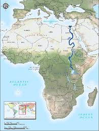
What river is highlighted? This is the longest river on earth from North to South. 
a)
Congo
b)
Zambezi
c)
Nile
d)
Amazon
14.
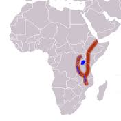
What geographic feature is highlighted? It is a ridge & plate boundary with lots of volcanic activity beneath its surface. Millions of years from now, it will split the continent in half.
a)
Sahel
b)
Transition Zone
c)
Ring of Fire
d)
Great Rift Valley
15.
What geographic feature is shown on the map? It marks the transition between Sahara Desert and the more hospitable savanna region.
a)
Great Rift Valley
b)
step
c)
Sahel
d)
Atlas Mountains
16.
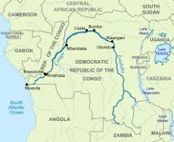
What river is highlighted? It flows through heavily forested regions in the center of the African continent.
a)
Congo
b)
Zambezi
c)
Kasai
d)
Nile
17.
What is the main geographic feature of Central Africa?
a)
The Congo River Basin & rainforest
b)
Nile River Valley
c)
Kalahari Desert
d)
Sahel region
18.
What physical feature in West Africa encouraged the movement of people, goods and ideas?
a)
Atlantic Ocean
b)
Mediterranean Sea
c)
Niger River
d)
Sahara Desert
19.

On what river is the Aswan High Dam found?

a)

Dalong

b)

Congo

c)

Nile

d)

Niger

20.

The physical geography and landscape of East Africa are dominated by what geological faults.

a)

the Great Rift Valley

b)

Irrigation

c)

Congo River Watershed

d)

earthquakes

21.

Because Central Africa is centered on the Equator, its climate is ________ .

a)

arid

b)

tropical

c)

mild

d)

desert

22.

Finely ground fertile soil good for growing crops

a)

Silt

b)

Irrigation

c)

oasis

d)

dirt

23.

Wet Fertile area of land located in the desert

a)

Oasis

b)

Silt

c)

Sahara

d)

Nile