wayground logo

Free Printable Worksheets

NEW

Font size

S
M
L
XL
Worksheets

Plate Tectonics Review

Total questions: 59

Worksheet time: 2hrs 16mins

Name
Class
Date
1.

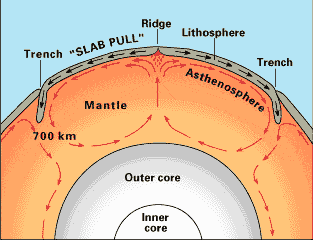
The movement of the tectonic plates is caused by

a)

the rotation of the Earth.

b)

convection currents in the Asthenosphere

c)

the gravity of the iron-nickel core.

d)

the Moho discontinuity.

2.

In some areas of the world, like California and Japan, earthquakes are a common occurrence. How can this best be explained?

a)

The strong ocean currents are undermining both areas causing earthquakes.

b)

Both areas are located near the edge of the Pacific Ocean, the unstable sand causes earthquakes.

c)

Both areas are subjected to strong ocean wind and waves that causes earthquakes.

d)

Both areas are on the boundary of active plates, the motion of the plates causes earthquakes.
3.
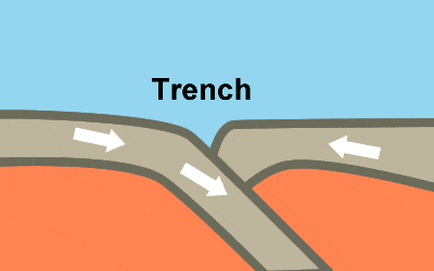
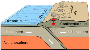
Subduction zones occur on Earth where dense oceanic crust dives under more buoyant continental crust. These boundaries are characterized by a deep ocean trench next to a high continental mountain range, large numbers of earthquakes and volcanoes. All of this is further evidence for the
a)
big bang theory.
b)
theory of plate tectonics.
c)
origin of the species.
d)
theory of natural selection.
4.
There are three types of plate boundaries. Which choice is NOT a type of plate boundary?
a)
convergent
b)
thrust
c)
divergent
d)
transform
5.

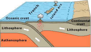
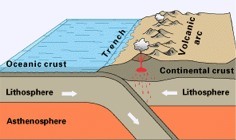
Observe this diagram of a plate boundary. One statement BEST describes what is happening. It is that

a)

the oceanic crust is melting.

b)

the denser ceanic crust is subducting under the less dense oceanic crust

c)

volcanic islands are forming.

d)

the tectonic plates are moving away from each other.
6.

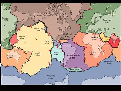
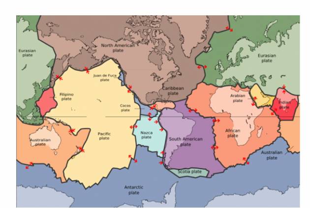
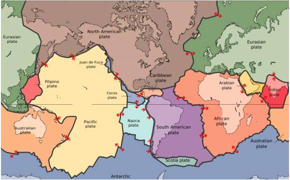
The map in the picture shows tectonic plate boundaries. This map would be useful in predicting the location of future

a)

droughts

b)

hurricanes

c)

earthquakes

d)

tornadoes

7.
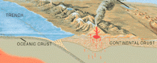
What geological forces might be responsible for this range of mountains?
a)
diverging tectonic plates
b)
erosion of the land by the ocean
c)
converging tectonic plates
d)
deposition of sediments by the ocean
8.

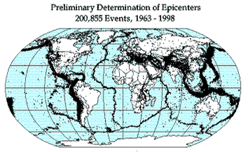
Earthquake epicenters (center of where the earthquakes started) were mapped for a 35 year period in the diagram above. The black dots indicate these epicenters. The black dots appear along what feature on Earth?

a)

hot spots

b)

plate boundaries

c)

rift zones

d)

sea floor spreading

9.
The Earth’s surface is not a solid surface but is divided into
a)
several oceanic plates.
b)
continental and crustal plates.
c)
seven continental plates.
d)
continental and oceanic plates.
10.
Geologists have long recognized that earthquakes are not randomly distributed on Earth but occur in concentrated areas that coincide with __________ and provide evidence for the theory of ___________ .
a)
mountain ranges; fault zones.
b)
continental borders; supercontinents.
c)
plate boundaries; plate tectonics
d)
areas of liquid magma; sea floor spreading.
11.
Which geological features MOST LIKELY prompted the development of the theory of plate tectonics?
a)
river deltas
b)
mountain ranges
c)
glacier fields
d)
tropical rainforests
12.

Where are earthquakes MOST LIKELY to occur?

a)

close to the equator

b)

close to the center of tectonic plates

c)

at divergent or convergent plate boundaries

d)

at transform plate boundaries

13.

The 2004 Indian Ocean tsunami was caused by a shift in two plates that pushed one section of the sea floor under another section of the sea floor by 5 meters. What type of boundary is this?

a)

divergent

b)

convergent

c)

transform

d)

metamorphic

14.
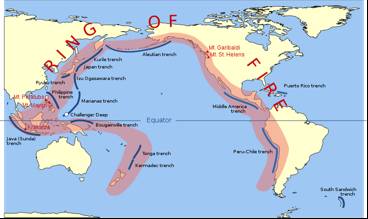
The image shows the Pacific Ring of Fire, a region of high tectonic activity. What evidence supports the theory that the tectonic activity of the region is due to the subduction of tectonic plates?
a)
The region is bound by many oceanic trenches.
b)
North America seems to be colliding with Asia at the north of the ring.
c)
The Asia-Pacific region is dotted by many small and large islands
d)
The landmasses look like they would fit together like the pieces of a jigsaw puzzle.
15.
The Atlantic Ocean gets about 3-5 ______ wider each year.
a)
centimeters
b)
kilometers
c)
miles
d)
meters
16.

___________ currents in the Earth's asthenosphere cause plate to shift at their boundaries. This movement also causes earthquakes and volcanic activity.

a)

conduction

b)

convection

c)

radiation

d)

ocean

17.
Observe the plate boundary shown here. What type of plate boundary is this? Many geologic events occur at these boundaries. Some are shown, but one is missing. What geologic event would you predict would occur at this plate boundary?
a)
convergent oceanic-oceanic plate boundary; volcano
b)
divergent oceanic-oceanic plate boundary; sea floor spreading
c)
convergent oceanic-continental plate boundary; earthquake
d)
convergent continental-continental plate boundary; mountain building
18.

What is the source of energy that drives plate movement?

a)

the subducton of the sea floor

b)

the different densities of the oceanic and crustal plates

c)

convection currents in the asthenosphere

d)

the friction force between the plates that move past each other
19.

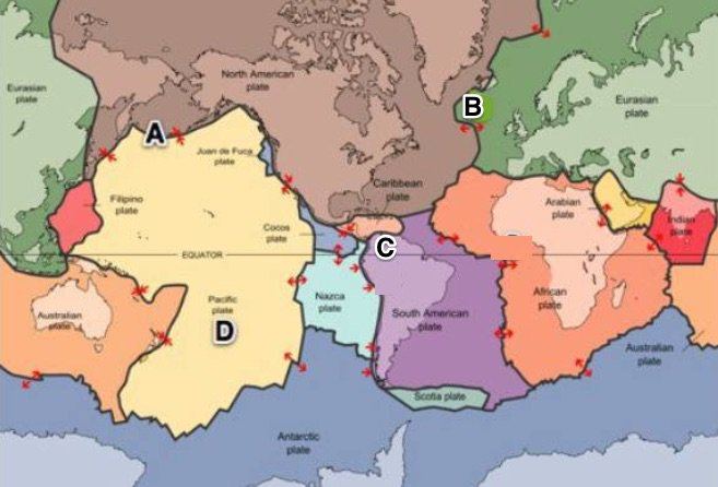
Where would sea floor spreading most likely occur?

a)

At convergent boundaries (oceanic vs. oceanic)

b)

At convergent boundaries (oceanic vs. continental)

c)

At divergent plate boundaries (oceanic vs. oceanic)

d)

At transform plate boundaries

20.

The Marianas Trench, where the Pacific Plate descends under the leading edge of the Eurasian Plate, is the deepest sea floor in the world. These ocean trenches form when two oceanic plates collide

a)

and the older, less dense of the two plates rides over the edge of the older plate.

b)

when convection currents in the mantle force the older plate downward.

c)

and the younger, denser of the two plates, rides over the edge of the older plate.

d)

and the plates are approximately the same age and density.

21.
What is a theory?
a)
An idea based on hypothesis and problems observed using five senses
b)
A belief, policy, or procedure that is not proposed or followed as the basis of action
c)
A supposition or a system of ideas intended to explain something, especially one based on general principles independent of the thing to be explained.
d)
A set of concepts that uses tests without evidences but uses the scientific method in order to prove a specific phenomena that happened on Earth or may happen to Earth
22.
What are the remains of organism noticed by Wegener that are found the same in two continents?
a)
Leaves and flowers
b)
Ice and mountains
c)
Plants and animals
d)
Dinosaurs and reptiles
23.
What causes the continents to move?
a)
Magma
b)
Tectonic Plates
c)
Earthquake
d)
All of the choices
24.
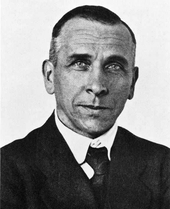
Who is the scientist who proposed Continental Drift Theory?
a)
Albert Einstein
b)
Alfred Wegener
c)
Isaac Newton
d)
John Dalton
25.
The geological theory that states that pieces of Earth's lithosphere are in constant, slow motion is the theory of
a)
subduction
b)
plate tectonics
c)
evolution
d)
seafloor spreading
26.
What type of evidence was NOT used by Alfred Wegener to support his continental drift hypothesis?
a)
evidence from landforms
b)
evidence from fossils
c)
evidence from human remains
d)
evidence from climate
27.
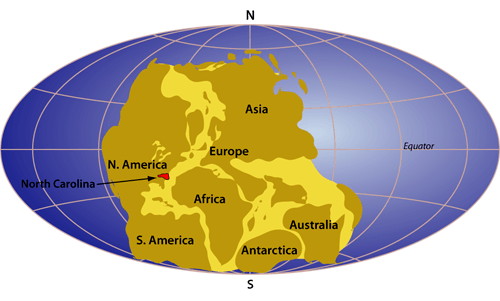
What is Pangaea?
a)
the name of a German scientist
b)
the name of the super-continent that existed millions of years ago
c)
another name for continental drift
d)
the name of an ancient fossil
28.
What are the two types of crust?
a)
continental and oceanic
b)
ocean and basin
c)
lower and upper
d)
thick and thin
29.
What is the force that moves the continents? 
a)
Conduction 
b)
Convection 
c)
Radiation 
d)
Conveyor belts 
30.
How does evidence of glaciation in Africa support the Theory of Continental Drift?
a)
It shows that the continents must have been in a different location.
b)
It doesn't. 
c)
I shows that it was colder at the equator in the past.
d)
It shows that it was warmer at the equator in the past.
31.
What does the word Pangea mean?
a)
big land mass
b)
old land
c)
all land
32.
How long ago is Pangea believed to have existed?
a)
200-300 million years ago
b)
1000-2000 years ago
c)
10,000-20,000 years ago
d)
20-30 billion years ago
33.
What two specific continents fit together most noticeably?
a)
Africa and North America
b)
South America and Europe
c)
South America and Africa
d)
Antartica and Africa
34.
Why did no one believe Wegener's thoery?
a)
He could not explain HOW the continents moved
b)
He didn't have evidence
c)
His data was wrong
d)
He didn't use the right technology to gather data
35.
What evidence did Wegener use in his theory?
a)
Continents and fossils fitting together/matching-up like puzzle pieces 
b)
glacier scars and evidence from temperature
c)
mountain ranges and coal deposits line up across continents
d)
all of the above
36.
What does the theory of continental drift state?
a)
The continents were once joined in a super-continent and have moved over time
b)
Continents are stationary and do not move
c)
The Earth is broken into lithospheric plates that move due to convection currents
d)
none of the above
37.
What is this a picture of?
a)
plate tectonics
b)
continental drift
c)
pangea
d)
glacier scaring
38.
Who is the person credited with developing the theory of continental drift?
a)
Harry Hess
b)
Galileo
c)
Alfred Wegener
d)
Newton
39.
Which of the following supports the theory of seafloor spreading?
a)
Correlation of rock layers
b)
Crustal Age
c)
Magnetic Reversal
d)
Continuous Mountain Chains
40.
What causes the crust to move?
a)
convection
b)
conduction
c)
tension
d)
radiation
41.
The zone where one plate slides under another is called the
a)
Convergent zone
b)
Subduction zone
c)
Transform zone
d)
Mantle zone
42.
The entire cycle of heating occurring in the mantle is called
a)
Convection currents
b)
Compound currents
c)
heat currents
d)
 subcurrents
43.
When looking at mid ocean ridges the oldest rocks are 
a)
In the middle
b)
Found close to the rift zone
c)
Found far from the mid ocean ridges
44.

What 3 kinds of evidence were used to prove that the seafloor spread?

a)

Rock formations, age of rocks, WWII shipwrecks

b)

Age of rocks, magnetic seafloor stripes, WWII ship logs

c)

Rock formations, magnetic seafloor stripes, age of rocks

45.
What technology was used during WWII to detect enemy submarines and produce the first map of the seafloor?
a)
Sonar
b)
Radar
c)
GPS
46.
Undersea mountain range.
a)
Rift
b)
Mid-ocean ridge
c)
seafloor spreading
d)
Continental drift
47.

Process by which new ocean crust forms.

a)

Seafloor spreading

b)

Continental drift

c)

Mid-ocean ridge

d)

Rift

48.
Magnetic field that points south.
a)
Modern polarity
b)
Past polarity
c)
Normal polarity
d)
Reversed polarity
49.
Why were magnetic patterns found on the ocean floor puzzling?
a)
They showed alternating bands of normal and reversed polarity.
b)
No rocks were magnetic.
c)
They did not show alternating bands of normal and reversed polarity.
d)
All rocks were magnetic.
50.
The OLDEST seafloor is located? 
a)
Closest to the mid-ocean ridge
b)
Farthest from the mid-ocean ridge
51.
What is label G
a)
Trench
b)
Mid ocean ridge
c)
abyssal plain
d)
sea mount
52.
What are Mid-Ocean Ridges?
a)
A chain of underwater waterfalls 
b)
A chain of underwater volcanos
c)
A chain of underwater mountains
d)
A chain of underwater rocks
53.
What evidence helps scientists show how sea floor spreading occurs?
a)
Ocean Floor Material
b)
Magnetic Stripes
c)
Drilling Samples
d)
All of the Above
54.

Sea-floor spreading begins at the

a)

Deep ocean trench

b)

Mid-ocean ridge

c)

Continent's edge

55.
New crust is always formed at the...
a)
mid-ocean ridge
b)
deep-ocean trench
c)
asthenosphere
56.
Older crust is found towards the...
a)
Mid-ocean ridge
b)
Deep-ocean trench
c)
Asthenosphere
57.
Which is NOT evidence of sea-floor spreading?
a)
Molten magma constantly erupting
b)
Drilling samples of rock
c)
Magnetic stripes
d)
Fossil evidence
58.

What is label D

a)

Trench

b)

Mid ocean ridge

c)

abyssal plain

d)

sea mount

59.

This scientist was the first to propose seafloor spreading

a)

William Watts

b)

Harry Hess

c)

Alfred Wegener

d)

Tenzing Norgay