
 Worksheets
Weather/Climate
Total questions: 100
Worksheet time: 1hrs 20mins
What causes wind?
difference in air pressure
difference in oxygen
differences in the gravity
difference in the thermosphere
What causes difference in air pressure?
even heating of the Earth
even cooling of the Earth
uneven heating of the Earth
global warming
Local winds blow over:
short distances
the poles
long distances
the equator
Which is NOT a characteristic of local winds?
They occur within a small area
They blow over short distances
Land and sea breezes are examples
They blow steadily over long distances
What is responsible for warming the Earth's surface and creating wind?
the Moon
Earth core
Coriolis effect
the Sun
How does the air move in a land breeze?
From east to west
from west to east
from the land to the ocean
from the ocean to the land
Air is warmer and less dense at the equator because the equator receives more.
wind
solar radiation
aire pressure
condensation
The Coriolis effect is the curving of the wind across Earth. What causes winds to curve?
Earth;s revolution
Earth's magnetic field
Earth's rotation
Earth's gravitational pull
Rain, snow, sleet, and hail are examples of:
evaporation
weather
climate
precipitation
The collection of water vapor into droplets as a result of cooling.
evaporaation
condensation
runoff
precipitation
Water flows on the earth's surface as a result of precipitation.
evaporation
runoff
condensation
precipitation
A region where air is sinking causing clear and calm weather.
high pressure
cold front
low pressure
warm front
The average, annual, or usual weather in an area
climate
weather
front
air pressure
A barometer is a weather instrument that measures
humidity
air pressure
wind speed
temperature
A mass of moving air that is cold, warm, or stationary
front
humidity
air pressure
condensatiion
Regions closest to ____ tend to have warmer year round climates.
Northern Hemisphere
Equator
Southern Hemisphere
Poles
The higher the altitude the _____ the temperature are.
hotter
colder
more consistent
weider
An/A _______ map shows air pressure or winds.
isotherm
weather
isobar
doppler radar
Which of the following is NOT a factor that affects climate?
latitude
winds
mountains
weather forecast
Assume that deforestation has taken place. How will this effect the movement of water through the water cycle?
runoff will decrease
sea level will increase
condensation will increase
transpiration will decrease
Warm air ______
rises
sinks
currents
clouds
What is the name of the surface ocean current that brings warmer temperature to SC?
Gulf Stream
California current
south Pacific
equatorial
What is the definition of "Greenhouse Effect"?
gases that increase Earth's temperature
when the gases in the atmosphere trap heat from the Sun and keep the planet warm
the pattern of weather that occurs over time
when our climate changes

Which of the following is NOT a statement the meteorologist would make about the weather?
The high temperature will be 55°F and the low will be 37°F.
A cold front is bringing in colder weather.
The wind speed will increase to 25 mph in the afternoon.
The average weather condition of the area is rainy.

Students measured the rainfall outside their classroom for five days and recorded their observations. The greatest increase in the amount of rainfall was between -
June 12 and June 13
June 11 and June 12
June 10 and June 11
June 13 and June 14

Why do all parts of the Earth not receive the same amount of sunlight?
The Earth is tilted on its axis.
The Earth is closer to sun in the winter.
The moon revolves around the Earth.
The Earth is very far away from the Sun.


Violently rotating column of air in contact with the ground crossing land in a narrow path
hurricane
tornado
blizzard
thunderstorm
Violently rotating column of air in contact with the ground crossing land in a narrow path
hurricane
tornado
blizzard
thunderstorm

These maps show points of equal barometric air pressure (wind speed).
isotherm map
isobar map
isodown map
temperature map
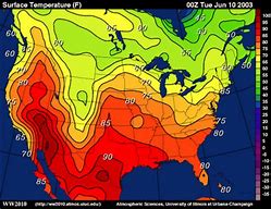
These maps connect points of equal temperature (THERMometer).
Isobar map
Isodown map
Isotherm map
Temperature map
Which best describes climate?
Summers are usually hot and dry.
It rained last week.
Yesterday it was cold and windy.
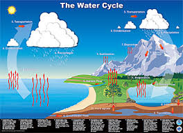
During which stage do clouds form?
condensation
evaporation
precipitation
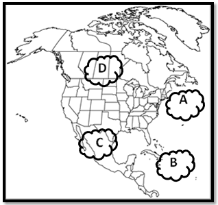
Which type of air would you find at air mass C?
cold, dry
warm, humid
warm, dry
cold, humid
This type of cloud is thin and flat and the edges are not clearly defined
cirrus
stratus
cumulus
cumulonimbus
This type of cloud is thick and puffy on top, and generally flat on the bottom. It has well-defined edges andcan change shape rapidly.
cumulus
stratus
cirrus
cloud 9
Nimbostratus and cumulonimbus clouds can signal what type of upcoming weather?
fair skies
hot sunny weather
windy weather
rainy weather


What's the dependent variable?
What's the dependent variable?

Which is best to represent a trend overtime?
Line graph
Bar graph
Pie graph
Complete the acronym. DRY
DEPENDENT- RESPONDING - _____________
y- axis
x- axis
Complete the acronym. MIX
MANIPULATED- ______________ - X-AXIS
Independent variables
Dependent variables
Write the correct flow of the scientific method?
Problem>Hypothesis>Materials>Drawing of
Set-up>Procedures>Data Analysis> Conclusion
Hypothesis>Problem>Drawing of
Set-up>Procedures>Data Analysis> Conclusion>Materials
Procedure>Hypothesis>Materials>Drawing of
Set-up>Procedures>Problem>Data Analysis> Conclusion


