
 Worksheets
Science category 3 TEST review
Total questions: 60
Worksheet time: 57mins




Theorized supercontinent that existed 200-300 million years ago.
Pangaea
Convection Currrent

Cycle of heating, rising, cooling and sinking that causes the plates to move.
Pangaea
Convection Current

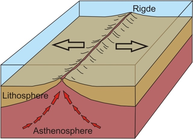
System of underwater mountain ranges that stretch along the center of the ocean floor at divergent boundaries.
Mid-Ocean Ridge
Convection Current

Select the 4 pieces of evidence to support Pangaea and Plate Tectonics Theory
Puzzle-like fit of Africa and South America
Rock Clues
Climate Clues
Fossil Evidence
Actual video footage of Pangaea

#1 shows which type of boundary?
Transform
Convergent
Divergent
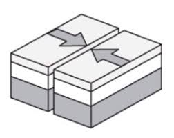
#2 shows which type of boundary?
Transform
Convergent
Divergent
#3 shows which type of boundary?
Transform
Convergent
Divergent
Cause: Continental Plates move apart from each other.
Effect:
Great Rift Valley in Africa is an example.
Volcanoes form along the edge of plate boundaries such as the Ring of Fire.

What type of plate boundary is between the African and South American Plate? What type of crustal feature would be formed here?
Divergent: Mid-Ocean Ridge
Convergent: Ring of Fire Volcanoes
Transform: Fault
What type of plate boundary is between the Pacific Plate and Eurasian Plate? What type of crustal feature would be formed here?
Divergent: Mid-Ocean Ridge
Convergent: Ring of Fire Volcanoes
Transform: Fault
What type of plate boundary is between the North American and Caribbean? What type of crustal feature would be formed here?
Divergent: Mid-Ocean Ridge
Convergent: Ring of Fire Volcanoes
Transform: Fault
What type of plate boundary is between the North American and Eurasian? What type of crustal feature would be formed here?
Divergent: Mid-Ocean Ridge
Convergent: Ring of Fire Volcanoes
Transform: Fault

Which of the above waves from the EMS would be the least energetic (longest wavelength)?
Gamma Rays
Radio Waves
Which of the above waves from the EMS would be the most energetic (shortest wavelength)?
Gamma Rays
Radio Waves

Rainy, "lazy" weather would be considered
High Pressure System
Low Pressure System
Stable Pressure System
None of the Above


Hurricanes are large areas of ____________ pressure.
High
Stable
Low
None of the above

The weather map shows the conditions across the United States. Based on the weather map which city would see an increase in temperatures over the next 24 hours?
Denver because it is raining here
Minnaepolis, because a cold front is approaching
Atlanta, because a warm front is approaching
Houston, because it is in a high pressure system

This the study and description of the shape of the land and surface features.
Biology
Topography
Geology
Oceanography


What could be the elevation of the mountain top?
860 km
840 km
841 - 859 km
861 - 869 km


Which of the following best describes how mountains change over time?
The elevation of the peaks will decrease due to erosion.
The elevation of the peaks will increase due to weathering.
The elevation of the peaks will increase due to deposition.
Mountains stay the same, they never change.
How do plants help stop erosion?
Plant roots anchor soil and sediment, keeping them from eroding.
Plants kick up sediments, keeping them from eroding.
Plants have no effect on erosion.
Plants increase the rate of erosion.

This is a satellite image of the Houston Ship Channel. Which point on this image will experience the most erosion?
A
B
C
D

This is a meteor crater. Which of the following is a prediction of how the crater will change over the next 1,000 years?
The crater will become more shallow as the sides erode into the center.
The crater will become deeper as animals make the crater home and burrow deep into the rock.
The crater will not change over 1,000 years.
The crater will fill in with lava.
Which of the following best defines weathering?
Process by which rock or sediment is moved.
Process by which rock or sediment is dropped in a new place.
Process by which rock is broken down by physical or chemical means.
None of these.
Which of the following best defines erosion?
Process by which rock or sediment is moved.
Process by which rock or sediment is dropped in a new place.
Process by which rock is broken down by physical or chemical means.
None of these.
Which of the following best defines deposition?
Process by which rock or sediment is moved.
Process by which rock or sediment is dropped in a new place.
Process by which rock is broken down by physical or chemical means.
None of these.



