wayground logo

Free Printable Worksheets

Font size

S
M
L
XL
Worksheets

Maps and Diagrams

Total questions: 114

Worksheet time: 2hrs 3mins
Name
Class
Date
1.
What is used to explain the symbols used on a map?
a)
map key
b)
map scale
c)
symbol
d)
map legend
2.
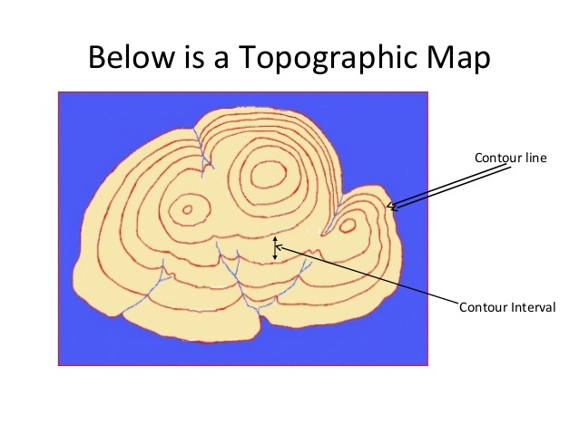
What do close contour lines represent on a map?
a)
waterfall
b)
steep area
c)
flatter area
d)
river
3.
What do contour lines that are farther apart represent?
a)
waterfall
b)
steep area
c)
flatter area
d)
river
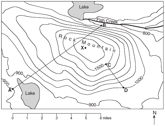
4.
How many mountain tops does this map have?
a)
one
b)
two
c)
three
d)
four
5.
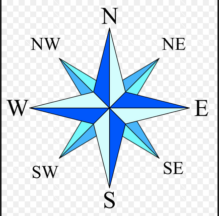
What is this? 
a)
This is a compass rose.
b)
This is a map scale.
c)
This is a key.
6.
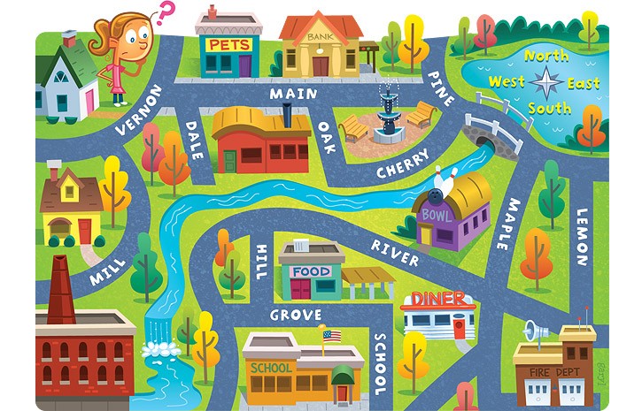
The school is ____ of the pet store.
a)
North
b)
South
c)
East
d)
West
7.
Lemon street runs _____________.
a)
East and West
b)
North and South
c)
South and West
d)
North and East
8.
The fire dept. is ______ of the school.
a)
South
b)
East
c)
North
d)
West
9.
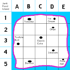
What is located in E5?
a)
Twizzles
b)
Ice Cream
c)
Chips
d)
Pizza Hut
10.
What is this object known as?
a)
map symbol
b)
map key
c)
map scale
d)
compass rose
11.

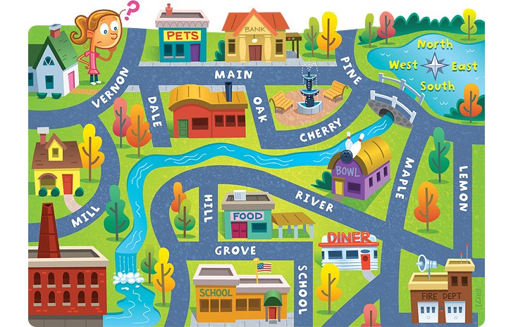
This map is an example of a . . .

a)

Population Map

b)

Thematic Map

c)

Climate Map

d)

Road Map

12.

This map is an example of a . . .

a)

Political Map

b)

Physical Map

c)

Population Map

d)

Road Map

13.

This map is an example of a . . .

a)

Topographic Map

b)

Political Map

c)

Survey Map

d)

Climate Map

14.

This map is an example of a . . .

a)

Physical Map

b)

Road Map

c)

Population Map

d)

Climate Map

15.
What type of map would be most helpful if you wanted to find a good location for your new restaurant with plenty of customers?
a)
Political Map
b)
Population Map
c)
Historical Map
d)
Topographic Map
16.

What type of map would be helpful if you were looking for an area that had a lot of mining jobs?

a)

Physical Map

b)

Resource Map

c)

Climate Map

d)

Historical Map

17.
What type of map would be most helpful if you were looking for a tall mountain range to go skiing?
a)
Population Map
b)
Political Map
c)
Thematic Map
d)
Physical Map
18.

A map showing mountains, rivers, oceans, valleys, and deserts is what type of map?

a)

Political

b)

Physical

c)

Population

d)

Climate

19.

A map showing boundaries of countries is what type of map?

a)

Political

b)

Physical

c)

Population

d)

Climate

20.

What type of map would you use if you wanted to find the countries bordering Egypt?

a)

Political

b)

Physical

c)

Road

d)

Topographic

21.

What map would you use to locate the largest body of fresh water in the world?

a)

Political

b)

Physical

c)

Resource

d)

Road

22.
A map showing mountains, rivers, oceans, elevation is what type of map?
a)
Political
b)
Physical
c)
Thematic
d)
Nothing
23.
A map showing boundaries of countries is what type of map?
a)
Political
b)
Physical
c)
Thematic
d)
Nothing
24.
A map showing the climate zones of North America is which type of map?
a)
Political
b)
Physical
c)
Thematic
d)
Nothing
25.
A map showing bodies of water, lakes, and islands is what type of map?
a)
Political 
b)
Physical
c)
Thematic
d)
Nothing
26.
A map showing cities, capitals, and states is which type of map?
a)
Political
b)
Physical
c)
Thematic
d)
Nothing
27.
What map would you use if you wanted to find the natural resources in an area?
a)
Political
b)
Physical
c)
Thematic
d)
Nothing
28.
What map would you use to find the capital of Texas?
a)
Political
b)
Physical
c)
Thematic
d)
Nothing
29.
What map would you use if you wanted to see the amount of rainfall in Dallas?
a)
Political
b)
Physical
c)
Thematic
d)
Nothing
30.
What map would you use to see the different vegetation in a region?
a)
Political
b)
Physical
c)
Thematic
d)
Nothing
31.
What type of map would you use if you wanted to find the countries bordering Egypt?
a)
Political
b)
Physical
c)
Thematic
d)
Nothing
32.
What map would you use to locate the largest body of fresh water in the world?
a)
Political
b)
Physical 
c)
Thematic
d)
Nothing
33.
What map would you use if you wanted to see different types of industries in a country?
a)
Political
b)
Physical
c)
Thematic
d)
Nothing
34.
What type of map would you use to see the population density of a region?
a)
Political
b)
Physical
c)
Thematic
d)
Nothing
35.
What type of map shows borders of countries is what type of map?
a)
Political
b)
Physical
c)
Thematic
d)
Nothing
36.
What map would you use to see flight patterns of planes over the United States?
a)
Political
b)
Physical 
c)
Thematic
d)
Nothing
37.
What map would I use to see the elevation of Mt. Everest?
a)
Political
b)
Physical
c)
Thematic
d)
Nothing
38.
What map would you use to see the traffic patterns in Frisco?
a)
Political
b)
Physical
c)
Thematic
d)
Nothing
39.
What map would you use to see the endangered tiger population in Kenya?
a)
Political 
b)
Physical
c)
Thematic
d)
Nothing
40.
What is another name for a map legend?
a)
Map Symbol
b)
Map direction
c)
Map Key
d)
Table of contents
41.
Which best shows the elements of a map?
a)
Scale, legend, title
b)
Scale legend, title, inset maps
c)
Scale, title, directional indicator
d)
Scale, title, inset maps, legend, directional indicator
42.
What is an inset map?
a)
Map that has been duplicated
b)
Smaller map on the same page as a larger map
c)
Map that provides the best directions
d)
Map with only boundary lines drawn
43.
Which element is important because it allows information to be acquired efficiently?
a)
Legend
b)
Scale
c)
Direction Indicator
d)
Title
44.
What is the purpose of a map scale?
a)
To weigh the political power of the states
b)
To show where things are located on the map
c)
Compare the distance measured on the map to the actual distance on Earth
d)
To show how large the map is
45.
What is the importance of a directional indicator?
a)
To give you directions
b)
To let the reader know where they are located on the map
c)
To point to the south
d)
Determine the orientation of the map
46.
Scales are often translated into how many miles are represented by one ___________.
a)
Inch
b)
Meter
c)
Millimeter
d)
Centimeter
47.
Which of the following is NOT a feature of inset maps?
a)
Drawn at a larger scale
b)
Feature areas of interest related to the large map
c)
Provide additional information not shown on larger map
d)
To point out places that should not be visited on the larger map
48.
What do map legends help determine?
a)
Meanings of symbols or colors that represent graphic features
b)
Orientation or direction map should be read
c)
Relationship of actual distance to map distance
d)
how efficient the map quality is
49.
Directions can be shown using a symbol with arrows pointing in all four cardinal directions. What is this symbol called?
a)
Compass rose
b)
Compass
c)
Astrolabe
d)
North arrow
50.

What informs the reader that a map is or is not still accurate?

a)

the compass

b)

publication date

c)

author's name

d)

the key

51.

What lines are drawn from the North Pole to the South Pole on a globe? Choose all that apply.

a)

Longitude

b)

Latitude

c)

Meridians

d)

Parallels

52.

Which lines run parallel to one another?

a)

Longitude

b)

Latitude

c)

Meridians

d)

International date line

53.

What shows a mathematical relationship between actual sizes and sizes shown on a map?

a)

the legend

b)

the key

c)

the orientation

d)

the scale

54.

The top of a map must always point North.

a)

True

b)

False

55.

Where can you find explanations for symbols on a map?

a)

the compass

b)

the legend

c)

the orientation

d)

the scale

56.

What map blends political and physical information?

a)

Thematic maps

b)

Road maps

c)

Cartograms

d)

Political maps

57.

What map freely distorts shapes, directions, and areas to display statistics?

a)

Thematic maps

b)

Road maps

c)

Cartograms

d)

Physical maps

58.

What map focuses on the symbolic display of data?

a)

Thematic maps

b)

Road maps

c)

Cartograms

d)

Topographic maps

59.

What map shows the shape of mountains sometimes using contours?

a)

Thematic maps

b)

Road maps

c)

Cartograms

d)

Topographic maps

60.
What is half of a sphere called?
a)
Halfsphere
b)
Semisphere
c)
Hemisphere
d)
Half circle
61.
On which two hemispheres do we live?
a)
Northern and Eastern
b)
Eastern and Southern
c)
Western and Southern
d)
Northern and Western
62.
Which imaginary line divides the Earth into the northern and southern hemispheres?
a)
Prime Meridian
b)
Equator
c)
Axis
d)
North Pole
63.
Which imaginary line divides the Earth into the eastern and western hemispheres?
a)
Prime Meridian
b)
Equator
c)
Axis
d)
North Pole
64.
Which part of the map shows the symbols located on the map and what they stand for?
a)
Compass Rose
b)
Grid lines
c)
Map title
d)
Map key or legend
65.
Which part of the map show the directions?
a)
Map Title
b)
Compass Rose
c)
Map key or legend
d)
Grid Lines
66.
Which part of the map uses letters and numbers to help you find where something is located?
a)
Map key or legend
b)
Compass Rose
c)
Grid Lines
d)
Map Title
67.
Which of the following is NOT a cardinal direction?
a)
North
b)
West
c)
Southeast
d)
East
68.
What do we call directions that come between the cardinal directions?
a)
Primary Directions
b)
Intermediate Directions
c)
Middle Directions
d)
Subdirections
69.
How many oceans are located on Earth?
a)
4
b)
5
c)
6
d)
7
70.
How many continents are located on Earth?
a)
5
b)
6
c)
7
d)
8
71.
Which of the following is NOT an ocean?
a)
Indian
b)
Atlantic
c)
Mediterranean
d)
Arctic
72.
Which of the following is NOT a continent?
a)
Asia
b)
Europe
c)
South America
d)
United States of America
73.
What is located in E5?
a)
Twizzles
b)
Ice Cream
c)
Chips
d)
Pizza Hut
74.
Where is Classic Coke located?
a)
A3
b)
B1
c)
C3
d)
D4
75.
How many continents are on the planet Earth?
a)
7
b)
4
c)

5

d)
102
76.
What continent is shown in red?
a)
Asia
b)
Africa
c)
Europe
d)
North America
77.
What continent is shown in red?
a)
Australia
b)
United States of America
c)
Africa
d)
Antarctica
78.
Maps should contain the following five things: 1) a title, 2) borders, 3) a compass rose, 4) ________, and 5) ________ .
a)
continents and countries
b)
landforms and water
c)
map key and symbols
d)
roads and golf courses
79.
What might this symbol stand for on a map?
a)
a ladder
b)
braces
c)
a black fence
d)
train tracks
80.
What comes to the right of the N (north) on this compass rose?
a)
S (south)
b)
E (east)
c)
W (west)
d)
N (north)
81.
What is represented by a symbol that looks like upside down V's? 
a)
capital
b)
airport
c)
highway
d)
mountains
82.
Recently, scientists have changed the number of oceans that was once on the planet. They now say that there are ____ oceans on planet Earth.
a)
5
b)
4
c)
7
d)
102
83.
What does the red line represent on this world map?
a)
equator
b)
international date line
c)
hula hoop
d)
the Red Sea
84.

What can a plan represent?

a)

Continents, countries, cities and villages.

b)

A street, a house, a building and a room.

c)

Earth, mountains and oceans.

d)

The weather.

85.

In which coordinate are the directional markers?

a)

C3

b)

E4

c)

E1

d)

5B

86.

How many types of maps are there?

a)

5

b)

2

c)

4

d)

7

87.

What type of map is this?

a)

Physical map

b)

World map

c)

Thematic map

d)

Political map

88.

What type of map is this?

a)

Phyiscal map

b)

Political map

c)

Weather map

d)

World map

89.

What is this?

a)

The directional markers

b)

The toponymy

c)

The key

d)

The scale

90.

A compass always points to the

a)

North

b)

South

c)

East

d)

West

91.

Where does the Sun rise?

a)

In the North

b)

In the South

c)

In the East

d)

In the West

92.

Which are the parts of a map?

a)

Rose of the winds, names, scale, conventional symbols and key.

b)

Directional markers, toponymy, scale, conventional symbols and key.

c)

World, Spain, rivers and countries.

d)

Compass, toponymy, scale, conventional symbols and key.

93.

What is the center line of longitude?

a)

Equator

b)

Prime meridian

c)

Longitude

d)

latitude

94.

What is the center line of Latitude

a)

Prime meridian

b)

Meridians

c)

Latitude

d)

Equator

95.

What is the center line of Latitude

a)

Prime meridian

b)

Meridians

c)

Latitude

d)

Equator

96.

The main directions on a compass rose are ....

a)

intermediate directions

b)

cardinal directions

c)

general directions

d)

directions

97.

On a map of UAE. This sign is next to Abu Dhabi because

a)

It is a city

b)

It has an airport

c)

It is a capital city

d)

It has a sea port

98.

What is half of a sphere?

a)

part sphere

b)

half sphere

c)

Hemisphere

d)

Sphere and half

99.

What shows what a map is all about?

a)

Map title

b)

Map scale

c)

Legend or key

d)

Compass rose

100.

What tells us which direction to go?

a)

Map key

b)

Map Title

c)

Compass rose

d)

Scale

101.

What is the name of the imaginary lines that run from east to west on the map of the world?

a)

Long lines

b)

Flat lines

c)

Latitude lines

d)

Longitude lines

102.

What is the name of the imaginary lines that run from east to west on the map of the world?

a)

Long lines

b)

Flat lines

c)

Latitude lines

d)

Longitude lines

103.

The point where Latitude and Longitude lines meet is our ____

a)

Location

b)

Absolute location

c)

Coordinates

d)

point

104.

What major line of Latitude runs through the UAE?

a)

Tropic of Cancer

b)

Tropic of Capricorn

c)

Equator

d)

Prime Meridian

105.

What mountain is formed when two plates are pushed together and creates folds?

a)

Fold

b)

Volcanic

c)

Block

106.

What mountain is formed from an opening in the earths crust that spits out lava?

a)

Volcanic

b)

Block

c)

Fault

d)

Fold

107.

Theses are created where two or more of Earth's tectonic plates are pushed together.

a)

Fault block mountains

b)

Fold mountains

c)

Volcanic mountains

108.

The Alps and the Himalayas are examples

a)

Fold mountains

b)

Volcanic mountains

c)

Block mountains

109.

Formed when plates moving apart causing cracks and faults

a)

Block mountains

b)

Fold mountains

c)

Volcanic mountains

110.

These are formed by magma rising up from the mantle to the crust of the Earth

a)

Volcanic mountains

b)

Fold mountains

c)

Block mountains

111.

An example: Mt. Fujiyama in Japan

a)

Volcanic Mountain

b)

Block Mountain

c)

Fold Mountain

112.

What is Magma ?

a)

Molten rock under the earth's surface

b)

Molten rock on the earth's surface

113.

Plateau mountains have what kind of tops?

a)

Flat

b)

Steep

c)

Pointy

d)

Round

114.

Explain the formation of 'fold' and 'fault' mountains.

4 lines