Wayground logo

Free Printable Worksheets

Font size

S
M
L
XL
Worksheets

Geo review Term1 questions bank

Total questions: 52

Worksheet time: 2hrs 10mins
Name
Class
Date
1.
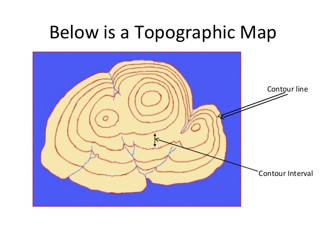
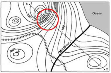
What do close contour lines represent on a map?
a)
waterfall
b)
steep area
c)
flatter area
d)
river
2.
How many mountain tops does this map have?
a)
one
b)
two
c)
three
d)
four
3.
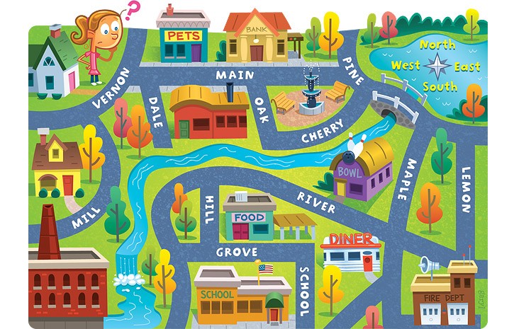
The school is ____ of the pet store.
a)
North
b)
South
c)
East
d)
West
4.
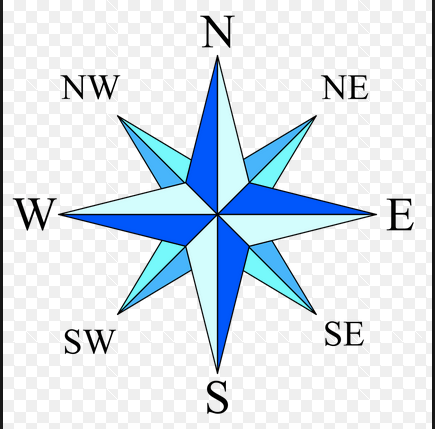
What is this object known as?
a)
map symbol
b)
map key
c)
map scale
d)
compass rose
5.

_________________ show the Earth as FLAT.

a)

Maps

b)

Globes

c)

Compass rose

6.

Which is the CAPITAL CITY of France?

a)

Paris

b)

Madrid

c)

Lisbon

d)

Rome

7.

_____________ maps show information like the mountains and rivers.

a)

Political

b)

Physical

8.

Africa is number:

a)

1

b)

4

c)

5

d)

3

9.

If you're having trouble finding out what the symbols on the map represent, where could you look?

a)

The back of the map

b)

The map legend

c)

The title of the map

d)

The compass rose

10.

A map's scale indicates that 1 cm equals 10 km. Two cities are 8 cm apart. How far apart are they in real life?

a)

10 km

b)

8 km

c)

80 km

d)

800 km

11.

An imaginary line or meridian measuring east or west of the prime meridian.

a)

longitude

b)

langoustine

c)

latitude

d)

geography

12.
A parallel of latitude north of the equator.
a)
Tropic of Casper
b)
Tropic of Candy
c)
Tropic of Cancer
d)
Tropic of Capricorn
13.

What is the 4-figure Grid Reference (GR) for the caravan?

a)

1632

b)

1631

c)

3116

d)

1531

14.

What is the 4-figure GR for the letter B?

a)

1531

b)

1432

c)

1530

d)

1431

15.

What is the 4-figure GR for the letter D?

a)

3117

b)

173317

c)

1731

d)

1832

16.
What is the 6-figure Grid Reference (GR) for the power station?
a)
1434
b)
141342
c)
146346
d)
152354
17.
What is the 6-figure GR for the letter A?
a)
1334
b)
145345
c)
139344
d)
135345
18.
What is the 6-figure GR for the red triangle?
a)
167313
b)
163317
c)
173323
d)
176317
19.
What is the 6-figure GR for the letter B?
a)
144309
b)
154312
c)
144310
d)
156310
20.
What is the 6-figure GR for the camping site (tent)?
a)
170328
b)
171312
c)
169312
d)
170311
21.
What is the six-figure grid reference for the campsite in Cranstock?
a)
815614
b)
806604
c)
614815
d)
851635
22.
What is at grid reference 837617?
a)
Aquarium
b)
Parking
c)
Sports Centre
d)
Public House
23.

Select correct statements.

a)

Latitudes are imaginary lines

b)

Latitudes are vertical lines

c)

Latitudes are point sized at the poles

d)

Latitudes are measured in degrees.

24.
What is the name of this line at 0 degrees latitude?
a)
Prime Meridian
b)
Equator
c)
North Pole
d)
South Pole
25.
What is the name of the line at zero degrees longitude?
a)
Equator
b)
Prime Meridian
c)
North Pole
d)
South Pole
26.
What is the approximate location of letter B?
a)
80oN, 0o
b)
0o, 80oW
c)
80oS, 0o
d)
0o, 80oE
27.
What is the approximate location of G?
a)
100oW, 40oN
b)
40oN, 100oW
c)
40oS, 100oW
d)
40oN, 100oE
28.
Which letter would you find at 15oS, 60oW?
a)
A
b)
C
c)
L
d)
H
29.
Which STATE is located at...
105°W, 47°N
a)
MT
b)
SD
c)
UT
d)
AZ
30.
Which STATE is located at...
120°W, 45°N
a)
WA
b)
OR
c)
UT
d)
ND
31.
Which STATE is located at...
100°W, 48°N
a)
NM
b)
ND
c)
SD
d)
CO
32.
Lines of Latitude can be measured up to what degree?
a)
150 degrees
b)
180 degrees
c)
90 degrees
d)
100 degrees
33.
Lines of Longitude run from the _____ to the ______.
a)
East, West
b)
North, South
c)
South, East
d)
North, West
34.
Latitude lines run from the _____ to the  _______.
a)
West, East
b)
North, South
c)
North, East
d)
South, West
35.
The equator breaks the Earth into what two hemispheres?
a)
Eastern and Southern
b)
Northern and Southern
c)
Western and Eastern
d)
Northern and Western
36.
Asia and Australia are in what hemisphere?
a)
Northern
b)
Southern
c)
Western
d)
Eastern
37.
Antarctica, Australia, and most of South America are in what hemisphere? 
a)
Northern 
b)
Southern 
c)
Western 
d)
Eastern
38.
North and South America are in what hemisphere?
a)
Northern
b)
Southern
c)
Western
d)
Eastern
39.
Lines of latitude are also called  __________.
a)
hemispheres
b)
Parallels
c)
Meridians
d)
Tropics
40.
Lines of longitude are also called  ____________.
a)
Hemispheres
b)
Meridians
c)
parallels
d)
International Date Lines
41.
What city is located at 32 degrees south and 150 degrees east?
a)
Shanghai
b)
Sydney
c)
Durban
d)
Calcutta 
42.
Which city is located at 38 degrees north and 120 degrees west?
a)
San Fransisco 
b)
New York
c)
New Orleans
d)
London
43.
What are the coordinates for the city of New Orleans? 
a)
30 degrees north and 90 degrees west
b)
60 degrees north and 30 degrees east
c)
30 degrees north and 120 degrees east
d)
35 degrees north and 70 degrees west
44.
To locate the exact places on Earth, one must look at: 
a)
latitude lines only
b)
the intersecting lines of latitude and longitude
c)
longitude lines only
d)
a neighboring area to describe the location
45.
Latitude and longitude are measured in ________.
a)
inches
b)
feet
c)
degrees
d)
grams
46.

A source created about an event or time-period by someone who was there

a)

Primary

b)

Secondary

47.

An article about the Civil War written during the Civil War

a)

Primary

b)

Secondary

48.

A report about the life of Abraham Lincoln written by a 5th grade student

a)

Primary

b)

Secondary

49.

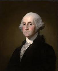
An autobiography of President George Washington

a)

Primary Source

b)

Secondary Source

50.
a)
Primary
b)
Secondary
51.
Which of these is NOT an example of a primary source?
a)
Original uniforms worn at a time in history
b)
Diaries written at the time of an event
c)
Film footage of a historical event
d)
A poem about World War II from your classmate
52.
What  type of source is this? A diary titled “Life in the Mines” from a miner named Lucky Noah who lived in Idaho in the 1870’s.
a)
Primary
b)
Secondary